Welcome to SENDITUR.COM · paths · routes · tourism


![]() Difficulty-Medium
Difficulty-Medium
![]() 3:50 h.
3:50 h.
![]() 16.2 km.
16.2 km.
![]() Difficulty-Medium
Difficulty-Medium
![]() 3:50 h.
3:50 h.
![]() 16.2 km.
16.2 km.
In the Najerilla Valley at the foot of Cerro del Castillo, in Nájera, a route begins that will transport us through history, going up the course of the river Cárdenas between a sea of vineyards and the monumental complex that forms the Monastery of San Millán de la Cogolla. The French Way brings us to the foot of the imposing Sierra de La Demanda whose rounded peaks of more than 2,000 meters observe the pilgrims of the Way of Saint James as they pass through La Rioja.

The stage 8b Variant of San Millán de la Cogolla with 16,2 Km starts from Nájera following the old Camino Real that will take us bordering the Cerro del Castillo through the path known as Pasomalo. A route that crosses a true archaeological site where we will be able to observe the caves Najerinas altomedievales, some spaces gained by the man to the mountain that they lean out to the farallón, as vertical viewpoints from where to dominate the valley that they have to their feet. Some hollows dug by man for his protection and that form a real network of galleries at different heights and communicated between them, which due to their special location made them almost impregnable. The route takes us away from Nájera and its Monastery of Santa María la Real, as we go up the bank of the river following the limits of the vertical cliffs.

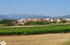
The mouth of the river Cordovín in the Najerilla, returns us to our time immersing us in a real sea of vineyards that, as if it were waves, makes us cross its hills gaining height with each step. An extensive valley, cut in the horizon by the San Lorenzo and the mountains that surround it, opens before us allowing us to contemplate beautiful panoramic views wherever we look. The Royal Way crosses the vineyards as it approaches the sierra while they gradually give way to cereal crops that claim part of the limelight. The town of Cárdenas remains on our left while we unknowingly continue to go up the course of the river that gives it its name. Badarán awaits us halfway, marking a point and apart from the route, as well as a real change in the landscape. The itinerary takes us through the locality that extends around the road that crosses it from side to side, making us pass by its Parish Church of Expectation of the seventeenth century.

Our journey to the limits of the town leads us to the Cardenas River, which will be our personal guide in this part of the journey that runs between the riverbank and the grain fields that surround it. After enjoying the freshness provided by this stretch of the Royal Way plagued with high poplars, Berceo invites us to a small detour to get to know it. From here the route continues its advance, now a little further away from the river, following the steps of San Millán, more specifically the route of Gonzalo de Berceo, which joins San Millán de la Cogolla and Berceo. Once again we will see ourselves walking through the town guided by its main street, which leads us without further delay to the enclosure of the Monastery of Yuso, the one below, which together with the Monastery of Suso, the one above, form part of the monumental group of San Millán de la Cogolla, Cradle of the Castilian and end of this stage.
The good communication between San Millán de la Cogolla and Nájera and the neighbouring villages by means of public transport allows us to organise our own accommodation so as not to miss the visit, almost obligatory, to this corner of La Rioja, being able to recover the layout of the French Way easily both on foot and returning to the starting point by bus to take up the Way again.
Entertaining route without great demands, in which you can enjoy nature on dirt tracks. The heat can be an inconvenience if it catches us crossing the vineyards without being able to find places where it is protected from the sun. Attention to the usual passage of tractors and harvesters in summer.
It is important to have enough water and food reserves, especially in the first half, as from the Cordovín stream we will not pass through any other water point to Badarán. In the second half of the route will give you a break and you can enjoy the streams that surely flood part of the way.
A couple of agricultural farms and the possessive pets that we will find on our arrival in Berceo and San Millán are usually the most we will have to take into account, unless we do the tour in hunting periods in which case it will be better to have our friend controlled by what might happen.
The square of Santiago, next to the municipal hostel of Nájera (0h 00min) is the starting point for this stage that will take us to the Cradle of the Castilian.

In this square we say goodbye to the original Way that continues towards Azofra, to our left, find the other street that, like the one that follows the Way, leads to the Market Square.

Already in this square, on the left side as we reach it, is the street that in a gentle climb brings us to the beginning of the Path Pasomalo.

The route takes us step by step out of the city letting us see the imposing wall that will accompany us in this part of the route.

This section marked by the verticality of the mountain has been repaired, but even so it is not exempt of possible landslides that prevent us from being able to follow this part of the route, in which case we will be obliged to turn off and continue along the road that leads from Nájera to San Millán de la Cogolla.

The route now runs between the mountain and the banks of the Najerilla, which we cannot see as it is hidden between the vegetation and the high poplars that inhabit its shore.

We advance leaving behind us a first vertical stretch that after giving us a short respite makes us walk again next to the clayey wall.

The route continues next to it, using the line that the mountain marks to guide us without major detours along the course of the river.

Soon we arrived at the crossroads where the yellow and blue marks that accompanied us until here separate following the blue route on our right and ours, the straight yellow. It is from here that we find ourselves again with a stretch in which work is being done to prepare it, due to the detachments that have taken place in the original Way. Work is being done on a new route next to the river, which will avoid the path that now follows halfway up the slope.

It is in this crossing where a few meters to our left we can find the beginning of this alternative route. The original route continues straight without detours facing a steeper stretch and in worse condition that runs along a narrow trail.

We quickly see how we gain height leaving the river and the new path a few meters below, following the path that holds as it can to the vertical wall that crosses us.

The landslides have covered some short stretch of path forcing us to pass them with caution, as it cannot be otherwise before arriving here it is convenient to have informed us of the state of the route and of the possible landslides that could have varied the state of the trail.

Our route leaves little by little behind the reddish hills that guided us here and now it makes us advance surrounded by the thick vegetation that almost covers its marked course.

The trail comes to an end when we find a path that climbs from the nearby river, where we have to follow.

This way makes us lose part of the height gained, taking us to the encounter of a new track next to the Cordovín stream, where we will be joined by the alternative way that arrives following the river bed. Already together both routes begin to go up again next to the small bed of the stream without forcing us to cross it for now.

After a short while the track we are going down divides into two and our route chooses the option on the left of the two we are presented with. Now we are going to cross the stream that hidden by the vegetation passes us almost unnoticed if it were not for the curve that describes the way to cross it.

The itinerary now takes us surrounded by vineyards that extend along the hills that stand in our way. The track climbs steadily, leaving on both sides the paths that connect the vineyards.

The long and uneven ascent requires us to face it with a certain calm, allowing us to look back to enjoy the landscape that we are leaving behind us.

At last we managed to save the hill we were ascending and the route changes orientation showing us the silhouette of the unmistakable San Lorenzo and the mountains that surround it. The route becomes much more comfortable, with hardly any unevenness and quite good firm.

The absence of obstacles allows us to contemplate a wide panoramic view of everything that surrounds us, a sea of vineyards that give way to fields of cereal as we lengthen our gaze.

This long stretch makes us leave to the left or right a good number of tracks that come out to meet us, without creating too many doubts about the path to follow.

After a while some vineyards split the path in two, this crossing lacks the relevant signposting and may lead us to make a mistake, partly because the path to follow, the one on the right, seems to be a track of the vineyard itself, although this is not the case.

The track on the right where we have to continue shows us again quickly the aspect and width that seemed to have lost and makes us continue maintaining the direction we have been for some kilometers.

Again we see ourselves advancing without major complications leaving to both sides how many tracks we are, following the straight course that marks us the reddish track by which we are going.

Although more gently we continue to gain little by little height at the same time that we continue crossing crossroads with other ways.

Badarán seems to hide from us, because no matter how much we follow with our eyes the long straight line drawn by the track we follow, we don't find any locality that is located how close we are to our next objective.

Almost without realizing it, the vineyards have been giving prominence to the cereal fields that almost cover everything around us. The route continues to take us without further detours, gradually approaching the valley of the River Cardenas, to which we must descend.

After a while, the ascent ends, allowing us to contemplate the silhouette of the locality that awaits us later on. The tour then begins the quick descent that takes us to the gates of the town.

Some agricultural pavilions force our track to turn to the left in search of the nearby road.

With no more detours, the route meets the road, where the marks guide us towards the interior of the locality.

The road, which introduces us to Badarán (2h 05min), is in charge of guiding us through the town.
A long journey awaits us through this town, which stretches along the road that crosses it from side to side. We have to follow its course without leaving it at any moment, crossing Badarán at the same time that we know part of its beautiful corners.

The church of the locality marks, more or less the half of our route, that continues for now straight without paying attention to the different streets that we cross.

Almost on the outskirts of the town, we arrive at the crossroads of Cordovín and Alesanco, which we will leave behind to continue the course that mark the road we are following. Until not long ago the Way, at this point, turned left to cross the river and go up its course by the opposite margin.

Already on the outskirts of the town, on our left, almost hidden among a few containers begins the road by which we must continue saying goodbye to the road.

This way descends quickly, taking us to the meeting of the municipal swimming pools, here we will follow by the way that borders them by the right.

Once again we see ourselves on a dirt track, this time with the nearby company of the road.

Our track describes a couple of sharp curves to walk towards a solitary agricultural pavilion.

Shortly after passing by the pavilion the way divides in two, we must follow the one on our left that leads us to the nearby river that we are about to wade.

We cross the river by the Queen's Vado, thanks to the bridge set up for it.

As soon as we pass to the other side we find a crossroads, here we have two possibilities, either turn right and follow the way more or less close to the river bordering the farms and the poplar grove of the riverbank.

Or you can continue straight ahead, moving a little away from the river until you come to a new path, which will make you keep going up the riverbed, although further away from it.

If we continue straight ahead, leaving the river behind us, soon after, when we begin to think that we are moving too far away from the river, we reach the limits of the row of poplars, this is where we will find the detour we must take to our right, to recover the previously lost course.

Now a little farther from the freshness of the riverbank, we again have before us the imposing silhouette of San Lorenzo. The track, in quite good condition, is protected on one side by a high slope and on the other by the cereal fields that separate us from the river limits.

After a while we will find ourselves in a new and wide crossing, here we have to leave the straight track by which we arrived and turn right to meet again with the river Cardenas, and with the other path that came closer to the river from the Vado de la Reina, and that joins us on our right.

Already the two options again together, we will go to a small bridge nearby that serves us to cross the river, as the route continues on its other side.

As soon as we cross to the other side to our left we have the road where we must continue and that leads us to pass next to the water treatment plant.

This way, something less stepped and in worse state than the previous one, returns to lead us following the line of poplars that border to the river. Once again we have another route without any more detours until we reach the end of the path we are following.

At the end of the tour, we leave the river behind and head towards the nearby Berceo (3h 25min).

We quickly found ourselves at a new crossroads where the itinerary changes course again, preventing us from continuing our ascent towards the town of Berceo, which we would enter if we went straight ahead.

The route now follows a comfortable track, first made of cement then asphalted, which takes us away from this locality. Without any further complications, we can already sense in front of us the final point of the route, from which we are no longer far apart.

Our asphalted track ends when it meets the road, just at the gates of San Millán de la Cogolla. We have to cross it to continue along the main street that will take us into the town.

This unmistakable street, marked by the drain that divides it in two, will act as a personal guide as we pass through the locality. The route advances without further detours following the layout of this street that crosses the town from side to side.

The limits of the monastery indicate the proximity of the end of the route, to which we arrive after crossing the entrance door to the enclosure of the Monastery of Yuso one of the jewels of San Millán de la Cogolla (3h 50min), where this stage ends.
 Distance. 16,2Km
In many places the itinerary for this stage is marked out entirely by road, which means that the distance is considerably longer.
 Time. 3:50h
The relatively short distance of the stage allows us to face it calmly, enjoying the places where it passes and the landscapes that surround us. Even so, the tracks throug:whic:it passes allow us to advance quickly and without major complications. If we approac:Berceo the time we take to visit it will have to add about 10 or 15 minutes of the detour.
 Time of year
The variety of the landscape gives this route a special beauty typical of eac:period of the year. The ochres and yellows of autumn rival the whites of winter and the different shades of green of spring resist giving way to the intense yellows of summer. The rainy seasons are the ones that can complicate our journey the most, the clayey soil, so appreciated by the vines, becomes a real mudflat that makes it very difficult to progress, it goes without saying that the Pasomalo stretc:is not very advisable to do it raining or in days after heavy rains.
 Required equipment
We approac:from the valley to the foothills of the Sierra de La Demanda so it is likely to find more thermal difference than normal. The route, except in some specific sections, allows us to wear more comfortable footwear. We cannot lack water and some food because the distances between localities, especially the first are considerable and we will not have water until them. In addition to clothing and footwear according to weather conditions and the time of year, it is not too muc:to add poles, a camera and a map of the area or GPS wit:the tracks. We also need protection against the sun, sunglasses, sunscreen, cap ... Consult our list of material and equipment to make the Way. Read more
 Difficulty. Medium
Physical
Without great ramps or great distances this stage does not suppose a great physical exigency, as long as we do not have to face the first half of the route in full sun in July or August in whic:case it will make it a little more difficult, but nothing remarkable compared to other stages. The absence of fountains between the localities should make us be cautious to avoid dehydration.
Caution
The greatest problem of this stage will be found in the section of Pasomalo, it is important to inform ourselves before entering it of the state of the route, as it is a landslide area. Normally the authorities in case of risk usually cut the accesses, but we may find ourselves in the final stretc:wit:landslides that cover the path. In this case we are working on an alternative pat:that runs next to the river, as the pat:is at medium height and depending on the state of the slope it is dangerous to try to pass the detachment. Normally this route is usually traveled by residents of Nájera who are making footprints in the rubble of the hillside, but before venturing to try to pass one of these landslides is better to take the pat:that goes next to the river that does not involve any complications.
Orientation
The route is signposted wit:the typical yellow marks of the Way that share protagonism in a short stretc:wit:the blue ones of the Medieval Way of Nájera. The route usually goes straight ahead at almost all the crossroads along the route, but unfortunately it is at the crossroads where we must turn off where the worst signposting is, in some cases null or difficult to see. This is partly due to the fact that althoug:the route has followed this course, pilgrims who wis:to follow this route are now being sent by road, leaving this route without unofficial maintenance of the signposting.
 |
 |
 |
 |
 |
| 1-Nájera | 0:00h | 487m | 0Km | 30T 521842 4695879 |
| 2-Badarán | 2:05h | 623m | 9.1Km | 30T 515789 4690560 |
| 3-Berceo | 3:25h | 698m | 14.6Km | 30T 512166 4687090 |
| 4-San Millán de la Cogolla | 3:50h | 735m | 16.2Km | 30T 511070 4685992 |
Coordinates UTM Datum WGS84

 Slope: 433m
 Slope +: 345m
 Slope -: 88m
 Maximum altitude: 735m
 Minimum altitude: 487m

This sketc:of the route is not made to scale nor does it contain all the information relating to the area, it is merely indicative.

![]()
This schematic wit:the pat:is approximate and has been created from the derived cartographic base © Instituto Geográfico Nacional "Cuadrante 203, 202, 241 y 240 1:50.000".
Senditur has manipulated the tracks to correct the aberrant points that may exist, caused by problems wit:the reception of the GPS signal. In any case the tracks are always approximate. SENDITUR encourages you to use the new technologies within your reach, using them as support and consultation in your activity, not basing the realization and orientation of the same only and exclusively on them, since they may see their functioning altered by very diverse causes, not functioning correctly and their indications may not be precise.


Emblematic place that reflects the stages of history, art and culture of the area


Cradle of the Castilian and pantheon of the seven Castilian heroes

Location of the Virgin of Valvanera, Patron Saint of La Rioja

Find out what to see in...
¿Did you know that...
In the Monastery of Suso the Emilianenses glosses appear, that were explanatory annotations in the margins of the pages written in Latin, the annotations were written in romance and also in a precastellano little evolved, in turn the first annotations written in euskera also are in this monastery.
Don't miss out...
Visits to both monasteries, the one in Suso, can be reached by bus from the grounds of the Monastery of Yuso, which in summer usually has nocturnal visits to the monastery that offer a different vision and atmosphere to what we are used to when we visit a monastery.


From the commitment of SENDITUR with Nature and the respect to the balance of the environment, SENDITUR urges you to travel in a responsible way, with low environmental impact and respecting at all times the Natural, Cultural and Social environment wherever you go.

Besides sharing with all of us your experience on the route we would be grateful if you could write to us to inform us of any erroneous or outdated information you may have found, or simply to let us know what you think at Thank you.
This route has been carried out in the field by SENDITUR on 16-08-2018. The route may vary greatly depending on the time of year, weather conditions and terrain, as well as the actions of third parties and the evolution suffered in the natural environment where it is located. All opinions, advice and/or assessments made by SENDITUR in their descriptions are for guidance only and are subject to and/or refer to the specific conditions of the specific day of the route, referring to that specific day, taken from trained people, with the appropriate experience and with a high level of physical and technical preparation as a reference, as well as correctly equipped.
All the times are approximate and take an orientative character, the stops have not been taken into account, no matter how small they are. All the information related to the route, texts, images, videos, maps, diagrams, tracks, towns, and places of tourist interest are published as a guide, and may not coincide with the current state of each place. Before undertaking any activity, assess your technical knowledge, your physical condition, find out about the weather and the variations that the route may undergo, equip yourself correctly, be prudent and responsible at all times, and do not exceed your capabilities. SENDITUR is not responsible for any misuse or inappropriate use of the comprehensive guides of its routes and/or publications as well as its electronic guides, nor for any variations in their descriptions for the aforementioned reasons, and recommends that everyone be responsible and prudent in carrying out the activity. We also encourage you to read books and specialised guides to complement the information described above.
Continue watching …


 Previous: Stage 7 Logroño-Nájera
 Next: Stage 8C Monasteries Way


.jpg "Go to Monastery of Suso")


