Welcome to SENDITUR.COM · paths · routes · tourism


![]() Difficulty-Medium
Difficulty-Medium
![]() 2:45 h.
2:45 h.
![]() 9.4 km.
9.4 km.
![]() Difficulty-Medium
Difficulty-Medium
![]() 2:45 h.
2:45 h.
![]() 9.4 km.
9.4 km.
![]()
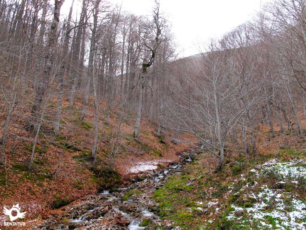
The valley of the Tobía River, sheltered by the high peaks of the Sierra of La Demanda, holds a true natural treasure. From the very foot of the Tobía rocks, the river takes us to the slopes of the Pancrudos, entering the spectacular landscape through which the Route of The Rajao runs, which forms part of the Routes between Beech Forest that run through these mountains and their villages. A route that will allow us to cross part of this beech forest at the same time that we contemplate the mountains that surround us or we follow the capricious course of the river.

The Route of the Rajao with 9.4 km starts from the surroundings of the Refuge of the Rajao, a meeting point, along with the recreational area that is in the vicinity, of many people who come to enjoy nature in its purest form. The itinerary takes us up the hillside of the mountain and into the leafy beech forest that we are going to walk through. As we advance, we cannot resist looking back to contemplate the imposing peaks of the Pancrudos that watch us in silence. Among the beech trees, we can sometimes contemplate the silhouette of the Tobía Rocks, such as that of Peñalba. The Tobía or Rajao Beech Forest extends around us while the route takes us to its most hidden corners, where small streams run down the hillside to meet the river they feed. The thickness, sometimes feels generous and allows us, for a brief moment, to enjoy the beautiful views that the height gained offers us.

The wood and livestock industry that has existed in these forests has coexisted with the coal and iron industry, whose vestiges can still be seen today in the form of small forges downstream and also with the mining industry, of which only the mouths remain, hidden among the vegetation. Mines such as the gold mine or the river mine, whose activity ceased many years ago. The beech trees share the limelight with the oaks and pines that also populate the area and with the river that from the spot known as The Three Waters, by the union of several streams in that place, will be the one that will accompany us until the end of the route. A river that hides beautiful corners that barely pass unnoticed by the hikers who travel these roads, more slopes of the thousand capricious forms that the trunks adopt in our path. The walk descends calmly following the course of the river along the slope of the Nevera Peak that stands between us and the Monastery of Valvanera. The shelter of El Rajao marks the point and end of this route in which for sure and with some luck we will have been able to meet some of the inhabitants that populate these mountains.

According to the legend, some disciples of San Millán, in search of their place of retreat, came across the beautiful spot of The Rajao Beech Forest, deciding to settle there in order to dedicate themselves to the contemplative life to which they had committed themselves. The life and miracles that these monks led over the years in these places contributed to the creation of the monastery of San Cristóbal known as The Three Cells, since the monks lived in three cabins.
To get to Tobía we will follow the LR-432 that after passing by Matute arrives at the town from the LR-331 that links the towns of Bobadilla and San Millán de la Cogolla. Tobía also has a bus service from Monday to Saturday that connects it with the nearby towns and with Logroño. Once there, we only have to follow the road we arrived on, which crosses the town and continues up the river. This road will take us past the El Rajao recreational area and soon after that we will find the path that, on our right, goes up to the refuge. If we are careful we will be able to see the building of the refuge, thus avoiding skipping this crossing where we will have to leave the road that still continues a few hundred meters more. In the surroundings of the refuge we will be able to park our vehicle to begin the route of hiking.
A good route to initiate our friend in the world of trekking and the mountain, of relative distance and demand should not create complications. Be careful not to leave him too much to his own devices, especially if he is not used to being in the middle of nature, as he can get confused and give us a hard time that will take us a few hours to find him.
Water should not be a problem since it almost surrounds us continuously, but in summer the small streams that flow down the slope can become dry, forcing us to bring him some water just in case.
On this route it is not unusual for us to come across the fauna that inhabit these forests, although they will normally have seen us before. We also have to take into account the hunting that take place in the area during their specific period and that are accompanied by the dogs that are used in them.
The Shelter The Rajao (0h 00min) is the starting and ending point of this ideal hiking route to do with children.

The itinerary is perfectly assimilable in both directions, it invites us to choose which one we want to follow. From the shelter, the track we will follow starts, which makes us start gaining height at the same time we leave the shelter behind.

The slope of the first ramps makes us doubt our choice. Quickly the track starts to zigzag down the side of the mountain lowering the demand to which we were submitted.

From the first moment we are surrounded by the thickness of the Beech Forest of the Carrascosa that surprises us with its colors. We continue ascending through the leafy beech forest following the perfect track that will guide us in this section of the route.

The itinerary changes direction again as it continues to gain altitude. There are not many crossroads or paths that we will find on our way and in all of them, the marks of the route are joined by the clear and defined state of the track we are on, leaving us no doubt about the direction to follow.

Almost without realizing it, the slope has been gradually smoothed out, allowing us to enjoy the views offered by the height we have gained.

Our path continues along the slope of the mountain, tracing the pattern that marks it and leads us to pass small streams through which the streams flow in search of the valley at our feet.

It is between two of these streams, when we reach a small clearing in the middle of a bend, just as the track leads back to the next stream, where we will find an unbeatable balcony from which we will have magnificent panoramic views (1h 10min).

From here we will take the path that takes us back to the beech forest. The track continues its winding course, bringing us closer with each step to the mountains that close the valley of the Tobía River.

Mountains that serve as a reference for us to follow when we come across a lonely road that goes out to meet us.

Without hardly noticing it, the pines have temporarily taken over from the beech forest, changing the landscape that had accompanied us until now. Soon on our left we will be able to see among the tree trunks the track that goes up next to the riverbed.

Dirt track that joins ours in the spot known as The Three Waters (1h 55min), indicating the moment when the itinerary turns sharply to follow the descending course of the river. Here we also find the signpost that indicates the starting point of the Rajao link with the GR 190. A route that climbs up to the Saleguillas pass, giving us the opportunity not only to link up with this long-distance footpath, but also to extend our itinerary and discover more charming corners of this part of La Rioja.

We continue our route and then embark on a steep descent following this track, which makes us happy with the decision we made at the beginning of the route.

The Tobía River shares prominence in this part of the tour with the Beech Forest of The Rajao while we lose altitude quickly.

The first strong ramps give way to a somewhat more benevolent profile, where we are surprised by the disparate shapes shown by the old beech trees that populate this valley.

We advance leaving behind a new track that goes up the mountain from the other side of the river. The route follows the course of the river at all times, as it approaches and moves away from us.

The track, now without any major complications, brings us closer to the end of the route with every step. The worn asphalt of the road we arrive on takes over, guiding us to our final destination.

The imposing beech trees accompany us to the same junction where we leave the road to climb up to the shelter The Rajao (2h 45min) where this trail ends, among beech trees.
 Distance. 9.4Km
If we wish, we can extend the route by following the variant that connects it with the GR190.
 Time. 2:45h
Following the route in the opposite direction to the one described can make us increase a little the time marked, due in part to the demand of the ramps that reach The Three Waters.
 Time of year
As everybody knows, autumn is the ideal time to contemplate the spectacle of colours provided by the beech forests. Although we should not underestimate the rest of the year as each season brings its special touch making this place a good option to visit at any time.
 Required equipment
The type of terrain through which the route passes allows us to do it with comfortable footwear, such as trekking shoes, as long as the weather conditions allow it. We do not have to forget that we are in the mountain, warm clothes or that it protects us of the wind depending on the epoch of the year in which we visit the zone, cannot be absent in the knapsack. In the area you will find a good number of recreational areas where you can enjoy a well-deserved lunch in the middle of nature. The landscape invites us to make good use of the camera at every step, you can not miss the binoculars if you want to see the birds that inhabit the rocks under which Tobia sits. Consult our list of material and equipment for hiking. Read more.
 Difficulty. Medium
Physical
Without a great distance, it is the unevenness to be overcome that will create the greatest complications, especially if we take the route by approaching The Three Waters first. For the rest, if we take it easy at the beginning, we will be able to enjoy the route without any major complications.
Severity of the environment
The good condition of most of the route, always on wide and marked tracks, will make the journey easier, as long as we do not go off the marked route. We will only have to be attentive in the short descent from The Three Waters to avoid slips. We do not have to forget that beech trees grow in humid lands so it will not be strange to find muddy or slippery areas if we leave the track we are on.
Orientation
The few crossroads or roads the route meets and the good condition of the track it runs on makes it extremely easy, under normal conditions, to follow the route without complications. In addition to this, the marks and signs of the route, present throughout the same, leaving no room for many doubts. Be careful if you go off the path, especially if there is fog, as it is relatively easy to get lost and not find the track you left behind.
 |
 |
 |
 |
 |
| 1-The Rajao Shelter | 0:00h | 1020m | 0Km | 30T 509577 4678028 |
| 2-Panoramic views | 1:10h | 1290m | 3.5Km | 30T 508706 4677962 |
| 3-The Three Waters | 1:55h | 1323m | 6.5Km | 30T 507498 4676120 |
| 4-The Rajao Shelter | 2:45h | 1020m | 9.4Km | 30T 509577 4678028 |
Coordinates UTM Datum WGS84

 Slope: 880m
 Slope +: 440m
 Slope -: 440m
 Maximum altitude: 1323m
 Minimum altitude: 1020m

This sketch of the route is not made to scale nor does it contain all the information relating to the area, it is merely indicative.

![]()
This schematic with the path is approximate and has been created from the derived cartographic base © Instituto Geográfico Nacional "Cuadrante 240-2 y 240-4, 1:25.000"
Senditur has manipulated the tracks to correct the aberrant points that may exist, caused by problems with the reception of the GPS signal. In any case the tracks are always approximate. SENDITUR encourages you to use the new technologies within your reach, using them as support and consultation in your activity, not basing the realization and orientation of the same only and exclusively on them, since they may see their functioning altered by very diverse causes, not functioning correctly and their indications may not be precise.


Buen paseo entre los hayedos de Rajao; Buenas vistas de los Pancrudos. Se disfruta sin mucho esfuerzo de un camino espectacular.

Preciosa y tranquila ruta en la que disfrutamos toda la familia a rabiar, el paseo entre los hayedos deja ver unas preciosas vistas y el lugar de Tres Aguas invita a un relajante descanso.

Location of the Virgin of Valvanera, Patron Saint of La Rioja


Cradle of the Castilian and pantheon of the seven Castilian heroes


¿Did you know that...
In the past, on the road that goes up from Tobía to El Rajao, the Monastery of San Cristóbal de Tobía, also called Three Cells, was located. According to the belief that this monastery, which dates back to the eleventh century, depended on the Valvanera. Today only an old plaque remains of it that indicates the place where it was located.
Don't miss out...
The Oak of the Eleven, one of the singular trees of La Rioja for its size and cultural value, and which you will be able to see at the foot of the Tobía Rock. It is named after the fact that it is at this time of day that the sun begins to shine on its highest branches. Every year in August there is a spectacular race that climbs up to this oak tree.


.jpg)

From the commitment of SENDITUR with Nature and the respect to the balance of the environment, SENDITUR urges you to travel in a responsible way, with low environmental impact and respecting at all times the Natural, Cultural and Social environment wherever you go.

Besides sharing with all of us your experience on the route we would be grateful if you could write to us to inform us of any erroneous or outdated information you may have found, or simply to let us know what you think at Thank you.
This route has been carried out in the field by SENDITUR on 25-03-2016. The route may vary greatly depending on the time of year, weather conditions and terrain, as well as the actions of third parties and the evolution suffered in the natural environment where it is located. All opinions, advice and/or assessments made by SENDITUR in their descriptions are for guidance only and are subject to and/or refer to the specific conditions of the specific day of the route, referring to that specific day, taken from trained people, with the appropriate experience and with a high level of physical and technical preparation as a reference, as well as correctly equipped.
All the times are approximate and take an orientative character, the stops have not been taken into account, no matter how small they are. All the information related to the route, texts, images, videos, maps, diagrams, tracks, towns, and places of tourist interest are published as a guide, and may not coincide with the current state of each place. Before undertaking any activity, assess your technical knowledge, your physical condition, find out about the weather and the variations that the route may undergo, equip yourself correctly, be prudent and responsible at all times, and do not exceed your capabilities. SENDITUR is not responsible for any misuse or inappropriate use of the comprehensive guides of its routes and/or publications as well as its electronic guides, nor for any variations in their descriptions for the aforementioned reasons, and recommends that everyone be responsible and prudent in carrying out the activity. We also encourage you to read books and specialised guides to complement the information described above.
Continue watching …


.jpg "Go to Monastery of Suso")


