Welcome to SENDITUR.COM · paths · routes · tourism

Stage 10 Belorado-Atapuerca
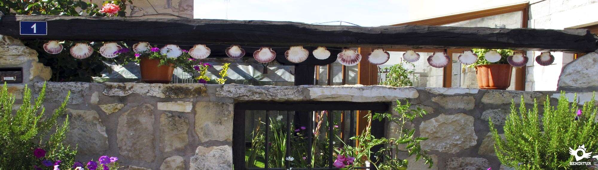
Belorado, Burgos![]()
![]()
![]()
![]()
![]() (1)
(1)
The Way of Saint James through lands that hold great secrets
![]() Difficulty-Remarkable
Difficulty-Remarkable
![]() 6:55 h.
6:55 h.
![]() 29.9 km.
29.9 km.
Belorado, Burgos![]()
![]()
![]()
![]()
![]() (1)
(1)
The Way of Saint James through lands that hold great secrets
![]() Difficulty-Remarkable
Difficulty-Remarkable
![]() 6:55 h.
6:55 h.
![]() 29.9 km.
29.9 km.
We head towards Atapuerca, in the foothills of the Castilian plateau, from Belorado in the valley of the River Tirón. This stage of the French Way offers us a changing landscape that goes from the cereal fields of previous days, passing through a medium mountain route, which means the ascent to the plateau saving the Mounts of Oca between leafy forests that clear to allow us to contemplate what we are leaving behind. Finally, the valley of the river Vera, place of great battles and natural border with the mountain range of Atapuerca that keeps magnificent archaeological treasures.

A long journey through Belorado, which allows us to enjoy this town, is the starting point of stage 10 Belorado-Atapuerca with 29.9 km. The striking walls decorated with Jacobean motifs give way to the convent of Our Lady of Bretonera, on the banks of the unique river Tirón. The first part of the route, which climbs gently, takes us to Tosantos, where we can contemplate the curious hermitage of Our Lady of the Rock, which enters the bowels of the mountain. From here the French Way brings us closer to Villambistia, where we will be greeted by its imposing 17th century church of San Esteban, located next to the Way of Saint James. The next stop comes shortly after in Espinosa del Camino, whose church of the Assumption of the XVI-XVII centuries keeps an interesting Baroque altarpiece. Shortly before arriving at the next locality we will find the remains of the old Mozarabic monastery of San Félix or San Felices de Oca, where according to some the tomb of Count Diego Porcelos, founder of Burgos.

Villafranca Montes de Oca, on the border with the Mounts of Oca, houses the once important hospital of San Antón Abad or the Queen, a 14th century royal building, and the 17th century neoclassical church of Santiago. A long stretch awaits us from here with the only company of the last leafy forest that we will enjoy in many days, a route that on the other hand allows us to contemplate a magnificent panoramic view of the mountains left behind in previous days such as La Demanda or San Millán. The rest area of the Mojapán Fountain, the monument to the Fallen and the imposing slide that will make us descend to the edge of the river Carratón, to recover the lost height in our ascent to the Pass de la Pedraja await us. San Juan de Ortega retired to these lands after being a tireless collaborator of Santo Domingo de la Calzada and founded the village of San Juan de Ortega, where he built a small hermitage erected to San Nicolás de Bari XII century, to which Isabel la Católica went in 1477, since the tomb of the saint was attributed certain abilities against sterility.

The descent of the Mounts of Oca leads us among the curious telluric circles to the nearby Agés, but not before we find one of the many variants that offer the possibility of changing the route, in this case if we decided to take a detour would take us to Burgos, the edge of the national. Agés is a beautiful Castilian village whose church dedicated to Santa Eulalia dates back to the 16th century and is situated a little far from the Way. We can also discover its old washing place and the Romanesque bridges attributed to San Juan de Ortega. A short distance away awaits us and Atapuerca, and before arriving, the place marked by the Pidrahíta where Don García Sánchez el de Nájera died in the battle against his brother Fernando I de Castilla. From this town guarded at the top of a hill by its church of San Martín from the XV-XVI centuries, the buses that will take us to know the important archaeological site of Atapuerca depart next to the house of San Juan, an old pilgrims' hospital.
The next stage that will take us to Burgos allows us thanks to its relative short distance, to accommodate is to our taste since the proximity between San Juan de Ortega, Agés and Atapuerca allows us to regulate the distance as we see our forces, leaving for the next day the pending stretch.
It is a hard journey, both in terms of distance and orography, with the advantage of almost all of it being travelled along good country roads and part of them in between woods. Perhaps there would not be other protectors for the legs because the pressing of the tracks can give them some problem. Beware of stretches of road with no hard shoulders and crossings with the national road where traffic is intense.
Very attentive to the water that we cannot miss as we pass through the port of La Pedraja, the only water points that we will find are too close to the village and it is not guaranteed that they have water. We will also pass by a stream, near the monument to the Fallen ones, without any good access and that we will be able to find dry.
In this stage the habitual thing is to find the typical mascots loose by the towns that we cross, also in times of raids we will have to walk with eye.
 |
 |
 |
 |
 |
 |
 |
 |
 |
 |
 |
| Belorado |  |
|
|
|
|
|
|
|
||
| Tosantos | |
|
| |||||||
| Villambistia | |
|||||||||
| Espinosa del Camino | |
|
||||||||
| Villafranca Montes de Oca | |
|
|
|
|
|
||||
| San Juan de Ortega | |
|
|
|||||||
| Agés | |
|
|
|
||||||
| Atapuerca | |
|
|
|
|
We begin the day next to the church of Santa Maria in Belorado (0h 00min), leaving it on our back we find a decorated wall that cuts our way, where we have to turn right.

Following this street a few steps away and at the first crossroads we find ourselves, we must turn left again to start walking the long street that will take us out of the town.

Forgetting how many crosses come out to meet us, we reach the height of the road that reaches the town from Haro and after crossing it we continue our straight route along Avda. de Santiago, somewhat wider than the street that brought us here. A little further on, just after leaving behind a street that enters from the nearby road, we arrive at a crossroads where we are presented with three options.

The one on the right goes towards the Convent of Santa Clara, the one on the left takes us directly to the road and the one in the centre where we will continue, lengthens the meeting with her a little more.

Following this track that runs through the outskirts of Belorado, we find the national. On the other side, a little displaced to our right is the beginning of a track next to a house.

After crossing the national road and as soon as you enter it, the Way turns right, bordering the house, continue parallel to the road. This section, a magnificent walkway, crosses the River Tirón and begins a gentle ascent that takes us past the back of a petrol station.

Shortly after we must cross a local road to continue on a dirt track that will take us to the next locality of the day.

The track crosses the deceptive plain of cereal fields and some trees, leaving behind the paths that reach it, approaching step by step to Tosantos (1h 00min), at whose entrance we must continue straight along the boundaries of the town.

Our journey through Tosantos reaches the height of a small park next to the town hall building, where on our left begins a dirt track away from the town.

Following this track we are gaining a little height that allows us, looking back, see the curious chapel that is introduced into the wall of the hill that crosses the town we just passed. The route almost without realizing it is saving the short distance and the gentle slope that separates us from the next objective, which we already see in front of us.

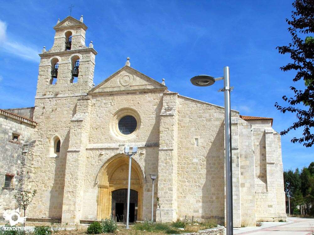
Shortly after crossing a path on our left, we reach Villambistia (1h 20min), which welcomes us with its beautiful church.
As soon as you pass the church, the path divides in two, one turns right and enters the locality and the other continues more or less straight down to the old washing places, protected from the elements by a roof.

When we arrive at the square where the washing places are, we find a fountain and in front of us the dirt track that will take us definitively out of Villambistia.

This track then begins a short ascent to reach the national, which we will be forced to cross again, but not before continuing a few meters on the shoulder in search of the path on the other side leads to the next town.

Shortly after crossing the road and after crossing a conditioned path we arrive at Espinosa del Camino (1h 45min), so that we can go straight on, getting to know this town.

The Way quickly leaves the municipality to find an old house whose façade shows the distances that separate us from some points of the Way.

Upon reaching this building, the itinerary continues to the right and then leaves the cement track on which we travel and turn left to continue along a dirt road that will climb to the hills that stand in our way.

Without leaving this track at any time and just after passing the ruins of an old chapel or tower, we are forced to turn left, the path ends in another that enters from the nearby road.

On reaching the national road, on our right begins a small trail that avoids us to follow the shoulder of the road.

This trail crosses as many obstacles on its way to a large car park that we will carefully cross straight until we come across the façade of the house in front of us, at which point we must turn left to follow the national route that takes us into Villafranca Montes de Oca (2h 35min).

The national road accompanies us for a short distance until we reach the church of the municipality, at which point we definitively leave the road and, on our right bordering the church, begin the long ascent that awaits us in front of us.

As soon as we leave the church behind along the steep street, we see in front of us the beginning of a cobbled trail that goes straight on between a wall and a slope of earth, leaving the path on the right. This trail meets again a little further on with the track, thus avoiding us to cross the turn that this one draws to avoid a plot.

The route now in clear ascent, passes through a dirt track in quite good condition, we are gradually gaining height allowing us, to reach a lookout, to contemplate the landscape that surrounds us.

The route continues along this track, leaving behind us some path that comes out to meet us as well as a small rest area, to get into a beautiful forest.

The itinerary continues gaining height, the vegetation gives way to some clear, the forest becomes of pines that escort us on both sides of the route.

The profile of the itinerary is smoothed, allowing us to walk a little more comfortably to incorporate ourselves shortly after passing an antenna, to another wide track that comes from the road and go up the short distance that separates us from the top of Mount Pedraja, a place that houses a monument in memory of the Fallen.

From here we continue straight on, leaving on our right a path that goes into the forest, to start the famous slide that so worries some pilgrims. The track parallel to the national one starts a vertiginous descent after crossing a narrow wooden bridge that crosses a stream to go up again the lost height.

The long straight that impresses view from any of its extremes, but that calmly is overcome without problems.

The route converges again with another wide track that comes from the nearby national and following it we are moving away from the road and ascending with a much less demanding slope.

The route continues straight on along the main track, crossed by rows of trees and stumbling over a good number of paths that we should not follow, giving us the impression that the track is rather a firebreak conditioned as such.

The Way leaves to the right the wide track that becomes clearly a firewall, to begin a gentle descent that takes us to our next destination.

Shortly after this detour and now clearly descending, the forest that accompanied us here gives way to the clear fields that allow us to sense the nearby San Juan de Ortega (5h 50min), which is on our left as the Way passes by the monastery of the same name that is located at the entrance of the town by the road that gives access.
We pass by this beautiful monumental site and continue straight on along the route of the small road that leads to here, which although it is not a road with excessive traffic, its non-existent hard shoulder and its small width make us watch out to avoid unnecessary scares.

Not long after leaving San Juan de Ortega we reach a crossroads and it is in this place where we are given the opportunity to continue on the road to our left joins the national and from there through a conditioned andadero next to it continue to Burgos. Claro is resting in one of the towns that we will find in the remaining 25 km to reach the capital.

This option may be advisable for the less skilful cyclists as it will prevent them from climbing the short but cobbled and uncomfortable high of the Sierra de Atapuerca, and also for those who are seduced by the idea of constantly having the national one on their side, as the towns they pass through are provided with services for pilgrims.

The Way leaves the road and continues along the track that begins next to the sign that signals this variant near an old telephone pole that many give by a huge cross.

The track in quite good condition is introduced back into the forest, going up a small hill that is between us and the penultimate population of the stage.

Leaving behind some crossroads in which we do not have to turn off and shortly after passing through a gate, the forest gives way to the fields, and through them the track we go along takes us to Agés (6h 35min). We arrive at this village flanked by the stone walls that delimit the orchards of the houses.
Following the street by which we enter the town we find the road, just next to a house whose entrance is decorated with the typical scallops santiagueras.

The route of the road will lead us through Agés towards the end of the stage. The final part of the route is made entirely by the local road that joins these two towns, without abandoning it at any time.

The final point of the route is already close, before we pass a small rest area next to a medieval bridge.

The road is not excessively narrow but without hard shoulder leads us to Atapuerca (6h 55min) which we enter following its route as it crosses the town and brings us closer to the centre of the town.
 Distance. 29,9Km
There are several possibilities to set a different final stage destination, thus reducing the distance to be covered.
 Time. 6:55h
Since there are no great shortcuts that can reduce the time spent, we will find places that deserve to waste some time getting to know them and enjoying them.
 Time of year
Althoug:in winter it is likely that the stretc:of road that runs throug:the pass of La Pedraja we find snow, being the stretc:of greatest distance between towns. In autumn, the woods we cross and the characteristics of the surroundings offer us colourful panoramic views. Colour contrasts are common all year round. In autumn, of course in winter and until well into spring the temperatures of the area especially at night can become quite low compared to the day.
 Required equipment
We have to take into account that althoug:in summer temperatures are high, in autumn and spring we can find hot days and quite cold nights, so we have to adapt our equipment to this circumstance. For the rest of the usual, footwear and hiking clothes according to the time of year and weather conditions, equipped backpack, canes. We can not miss the canteen wit:water and food, especially in the stretc:from Villafranca Montes de Oca to San Juan de Ortega, in addition to the camera, sunglasses and sunscreen. Consult our list of material and equipment to make the Way. Read more
 Difficulty. Moderate
Physical
A demanding stage, whic:allows us to be warmed up little by little to face the ascent to La Pedraja, a long ascent that has more unevenness at the beginning, but whic:then becomes quite soft. The slides that we found in previous stages continue in this one, reaching their maximum exponent just after crowning the pass, where as if it were a roller coaster we have to face a strong descent and its subsequent ascent. The final part is more comfortable almost at all times losing height but in a gentle way. The distance added to the orography of the terrain make this an intense stage, but bearable calmly and without losing too muc:energy in the mountain pass.
Caution
The national road crosses our path, forcing us to cross it several times and even to walk a short stretc:along its shoulders. This road withstands a lot of traffic so we must take extreme precautions. We will also have no choice but to travel a few 3 km by local roads not very narrow but without hard shoulder. The rest of the route does not present great complications unless the weather does not accompany. In the section that goes from Villafranca Montes de Oca to San Juan de Ortega we cannot lack the water and some food, it is the longest between localities and the few points of water that we will pass do not have the sufficient sanitary guarantees. In addition they are almost to leave Villafranca, so the summer days bring enoug:water is very important.
Orientation
The route is well signposted, wit:some signs coinciding wit:those of the GRs that cover the area, but as practically all of them run along wide, well-defined paths, they do not pose a problem. At the exit of Belorado just after crossing the road is the point, whic:althoug:it is signposted, causes more problems to pilgrims, as the moment you enter the track the Way deviates and it is usual to skip the signs, especially if it is night. For the rest the good state of the tracks that follows the Way also serves as a guide in case of doubt. The problems can be found in winter if we want to face the mountain pass snowed, having then the line of trees almost as the only reference to follow.
 |
 |
 |
 |
 |
| 1-Belorado | 0:00h | 770m | 0Km | 30T 484488 4696513 |
| 2-Tosantos | 1:00h | 821m | 5Km | 30T 479928 4695681 |
| 3-Villambistia | 1:20h | 865m | 6.7Km | 30T 478509 4694744 |
| 4-Espinosa del Camino | 1:45h | 900m | 8.3Km | 30T 476963 4694839 |
| 5-Villafranca Montes de Oca | 2:35h | 946m | 11.8Km | 30T 474590 4693021 |
| 6-San Juan de Ortega | 5:50h | 1004m | 23.7Km | 30T 464058 4691584 |
| 7-Agés | 6:35h | 967m | 27.4Km | 30T 460560 4690970 |
| 8-Atapuerca | 6:55h | 955m | 29.9Km | 30T 458229 4691684 |
Coordinates UTM Datum WGS84

 Slope: 815m
 Slope +: 500m
 Slope -: 315m
 Maximum altitude: 1145m
 Minimum altitude: 770m

This sketc:of the route is not made to scale nor does it contain all the information relating to the area, it is merely indicative.

![]()
This schematic wit:the pat:is approximate and has been created from the derived cartographic base © Instituto Geográfico Nacional "Cuadrantes 201, 1:50.000".
Senditur has manipulated the tracks to correct the aberrant points that may exist, caused by problems wit:the reception of the GPS signal. In any case the tracks are always approximate. SENDITUR encourages you to use the new technologies within your reach, using them as support and consultation in your activity, not basing the realization and orientation of the same only and exclusively on them, since they may see their functioning altered by very diverse causes, not functioning correctly and their indications may not be precise.


Bonita etapa a través de los Montes de Oca, con sitios muy interesantes en su trayecto como el, espectacular y y lleno de leyendas, monasterio de San Juan de Ortega. Es una de las etapas del camino que no me importaría volver a hacer. Aunque acabe muy cansada me lo pasé genial.

Manganese mines whose exploitation is probably one of the oldest in Spain

Great encyclopedia of the evolution of man, natural treasure kept in time

Find out what to see in...
¿Did you know that...
On equinox days, in the church of San Juan de Ortega, the sun bursts a few minutes inside, projecting its luminous rays on the capital where the Annunciation, Visitation and Nativity are represented. This spectacular event, called Miracle of Light, is added to the different symbologies that we will find as we go along, linked to the telluric beliefs attributed to this area.
Don't miss out...
The Atapuerca archaeological sites, brought to light by the railway trench built at the end of the 19th century, are considered to be one of the most important sites as they contain fossil finds of different hominid species. The visit can be made by bus from Atapuerca and Agés.


From the commitment of SENDITUR with Nature and the respect to the balance of the environment, SENDITUR urges you to travel in a responsible way, with low environmental impact and respecting at all times the Natural, Cultural and Social environment wherever you go.

Besides sharing with all of us your experience on the route we would be grateful if you could write to us to inform us of any erroneous or outdated information you may have found, or simply to let us know what you think at Thank you.
This route has been carried out in the field by SENDITUR on 20-09-2018. The route may vary greatly depending on the time of year, weather conditions and terrain, as well as the actions of third parties and the evolution suffered in the natural environment where it is located. All opinions, advice and/or assessments made by SENDITUR in their descriptions are for guidance only and are subject to and/or refer to the specific conditions of the specific day of the route, referring to that specific day, taken from trained people, with the appropriate experience and with a high level of physical and technical preparation as a reference, as well as correctly equipped.
All the times are approximate and take an orientative character, the stops have not been taken into account, no matter how small they are. All the information related to the route, texts, images, videos, maps, diagrams, tracks, towns, and places of tourist interest are published as a guide, and may not coincide with the current state of each place. Before undertaking any activity, assess your technical knowledge, your physical condition, find out about the weather and the variations that the route may undergo, equip yourself correctly, be prudent and responsible at all times, and do not exceed your capabilities. SENDITUR is not responsible for any misuse or inappropriate use of the comprehensive guides of its routes and/or publications as well as its electronic guides, nor for any variations in their descriptions for the aforementioned reasons, and recommends that everyone be responsible and prudent in carrying out the activity. We also encourage you to read books and specialised guides to complement the information described above.
Continue watching …
 Previous: Stage 9 Santo Domingo de la Calzada-Belorado
 Next: Stage 11 Atapuerca-Burgos


.jpg "Go to Puras de Villafranca Mining Complex")


