Welcome to SENDITUR.COM · paths · routes · tourism


Stage 21 Ponferrada-Villafranca del Bierzo
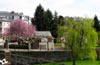
Ponferrada, León![]()
![]()
![]()
![]()
![]() (0)
(0)
The gentle plain that precedes the demanding mountain
![]() Difficulty-Medium
Difficulty-Medium
![]() 5:20 h.
5:20 h.
![]() 23 km.
23 km.
Ponferrada, León![]()
![]()
![]()
![]()
![]() (0)
(0)
The gentle plain that precedes the demanding mountain
![]() Difficulty-Medium
Difficulty-Medium
![]() 5:20 h.
5:20 h.
![]() 23 km.
23 km.
For the lands of the Bierzo, the fertile valley of the Sil will accompany us from Ponferrada in our approach to the mountainous cordal that forms the natural border of Galicia, being Villafranca of the Bierzo the door of entrance chosen by the French Way to enter it. A route that combines an urban layout with the still recent industrial history of the area, which flourished years ago around the energy industry leaving as a legacy the characteristic physiognomy of the populations born around it. Luckily the region soon offers us a change of landscape dominated at first by its ancestral orchard and its great variety of products that quickly give way to the vineyards that own the landscape, giving us in autumn a spectacle of reddish and ochre tones that together with the chestnut trees and mountains that surround us make the journey a pleasure for the eye.

The stage 21 Ponferrada-Villafranca del Bierzo del Camino de Santiago, with its 23 km begins in the heart of Ponferrada, whose streets are extended enveloping the route, not without first letting us say goodbye to the city contemplating the beautiful picture formed by the river Sil as it passes under the Templar Castle of the town. The Energy Museum puts the point and followed the long urban route, being the antechamber of the arrival of the French Way to Compostilla, but not before going through the network of buildings that grew around the thermal power station that dominated the area. Almost without time to say goodbye to this second urban nucleus we find the solitary church of San Esteban, which indicates the next arrival in Columbrianos, where the orchards and the cultivated fields take over the landscape preparing us to return to the habitual environment of the French Way.

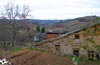
Fuentesnuevas and its hermitage of the Divine Christ, which still conserves the original bell of the old temple of the Vera Cruz that stood in the same place, return us for the moment to the reality of the urban layout that still awaits us in front. Without hardly noticing it, we are once again enveloped by the buildings. The great avenue to which we left, as if it were a long tiralíneas, arrives without detours from Ponferrada, taking us to Camponaraya. The singular clock tower together with the parish church of San Ildefonso and the chapel of the Virgen de la Soledad are some of the attractions that this locality offers to its visitors and mark the final point of the long urban layout that has accompanied us. A landscape dominated by vineyards that extends along the route and embedded between high and not so distant mountains, are the letter of presentation of Cacabelos, which shows us part of its long history that goes back many years.

This well-kept locality offers all its charm to pilgrims and visitors as well as an important historical and cultural contribution such as the Archaeological Museum, the hermitage of San Roque from the 17th to 18th centuries, the church of Santa Maria from the 16th century or the bridge, from the 16th and 18th centuries, which serves to cross the river Cúa, bringing us closer to the Sanctuary of Quinta Angustia from the 18th century, where there is an image of the Child Jesus playing cards with San Antonio de Padua. Pieros and its Romanesque church of San Martín, are the point that marks the possibility of continuing to Villafranca without further delay or on the contrary approaching Valtuille de Arriba, thus avoiding a dangerous stretch by road. The final point of this stage is the monumental Villafranca del Bierzo, which invites us to walk around it discovering its 12th century Romanesque church of Santiago, famous for its Door of Forgiveness, the 16th century castle of the Marquises of Villafranca, the 16th century convent of San Nicolás, the 16th century collegiate church of Santa María or the 13th century Gothic church of San Francisco, which form part of its rich artistic and cultural heritage.
Given the relatively short distance of the stage we can consider extending to Trabadelo, covering the little more than 9 km of andadero that separate Villafranca del Bierzo from this locality, thus partly reducing the hardness of the route that awaits us on the next day.
This is a propitious stage to focus on recovering energy and possible problems that could have due to the mileage accumulated, as it is not too long or with great slopes. The heat and lack of shade can play against you, also the asphalt will accompany us for much of the route, otherwise it will travel on dirt track in very good condition.
The water should not be a problem to find the localities very close to each other. Being from Camponaraya from where we can not fail to bring the water reserves to the top to be able to give it drink when needed, as we have ahead of us one of the longest stretches between towns.
The urban route is nothing we are not used to in our cities. If we have to be careful to pass between the orchards from Columbrianos to Camponaraya because we can find the dogs that protect them, it is also a common area where storks usually look for food. Another conflictive point we will find it to the arrives to Villafranca where in addition to hens by the way it is not rare to find some dog loose and not very good character.
 |
 |
 |
 |
 |
 |
 |
 |
 |
 |
 |
| Ponferrada |  |
|
|
|
|
|
|
|
|
|
| Cuatrovientos | |
|
|
|
|
|
|
|||
| Compostilla | |
|
| |||||||
| Columbrianos | |
|
|
|
||||||
| Fuentesnuevas | |
|
||||||||
| Camponaraya | |
|
|
|
|
|
|
|
||
| Cacabelos | |
|
|
|
|
|
|
|
|
|
| Pieros | |
|
||||||||
| Valtuille de Arriba | |
|
||||||||
| Villafranca del Bierzo | |
|
|
|
|
|
|
|
|
|
The Virgen de la Encina square, where we finished the route yesterday, is our starting point from Ponferrada (0h 00min).

In the middle of the square, to our left as we leave the Clock Street in front of us, almost hidden between the arcades begins a steep slope that we have to follow.

The stairs that we have to descend are, to be sure, the reason for the detour that the cyclists have found, joining us shortly after starting.

The street El Rañadero, on which we go, ends in the Nieves square, next to the river Sil. A wide avenue now serves as a guide making us cross the river and taking us to the first point of the day where we will be offered several options to continue.

A few metres after crossing the river, when you reach the first street on your right, the signs for the Way of Saint James indicate that it continues along it. However, every day the other option that takes us to Camponaraya becomes stronger and consists in continuing straight ahead the course of the extensive avenue that without detours will take us to this locality, saving us a few kilometres.

The original French Way turns right on this street to quickly return to the course we were following and advance parallel to the nearby avenue.

The wooded and wide street that we follow is soon cut by Huertas del Sacramento Avenue, by which turning right into it, we have to continue.

This long street leads us without detours approaching the outskirts of Ponferrada, leaving behind all the crosses we find.

After a short but uncomfortable climb we arrive at a roundabout that facilitates traffic at the intersection of our avenue with the Avenida de la Libertad. Turning to the right the Way of Saint James continues for this new avenue that will take us definitively out of the city.

As soon as we can it is advisable to pass to the left sidewalk according to the direction of our march as this will avoid us having to face more crossings.

The route continues without detours leaving on the right the factory that houses the National Museum of Energy, the route of the French Way in this area has undergone several alterations, passing in its day between the museum and the riverbank.

A few metres after leaving the museum buildings behind, we arrive at a new crossroads where we now have to take a detour to continue along the road that, to our left, goes away under the shade of the trees that border it.

We quickly reached the place where the street forks, leaving the road on our left we have to continue the straight course we were bringing.

Once again, we advanced among the trees that act as guides, ignoring the crosses we came across, until we reached the end of the road we traveled. Here, in front of us, we will see a passage that crosses the block of houses that has got in our way, a passage that we will cross.

A small park leads us directly to a coquettish hermitage bordered by hedges, being on its left side where we find a cobblestone path, he continues the itinerary.

After this hermitage the route takes us back to a street going straight ahead and going through what looks like a residential area.

Once again we are forced to turn a few meters to the left in search of the beginning of a new street that allows us to continue with the straight run that we carry.

Between a sports complex and the residential area we find a typical crossroads, just before having to cross a new crossroad to be able to continue with the straight line that draws the route.

The houses seem to give way to an open space and the asphalt of the street to the earth of the way, although both do not last long since quickly the route returns us to the asphalt of the street surrounded by houses.

The Way of Saint James passes through the outskirts of Compostilla (0h 40min) with hardly any intuition that we are crossing this town united to Ponferrada.

The route goes straight on without detours until we leave behind all the houses that surround us and find ourselves with a new crossing where we have to leave on our left an asphalted track and on our right a couple of dirt tracks to go straight on starting a gentle ascent.

The route crosses under the national VI to get away from it in search of a new crossing. The buildings have now given way to fields where you can already see some vineyards.

When you reach the crossroads, turn left and follow the asphalted track, leaving a dirt track that goes straight on. The almost imperceptible ascent continues to take us past the cemetery of the next town we will cross.

As soon as we pass the cemetery, the asphalted track on which we are going draws a kind of zeta, leaving on the right a path that leads to it. The route follows the course marked by the asphalt, giving us the possibility of shortening this curve by crossing an area of grass.

We soon reached the height of the church of San Blas, which marks the point where the next village begins, which still has a long way to go.

We continue without turning off until the road we are going along makes us think that we can not continue straight, at which time, ignoring the layout it makes, we continue straight ahead in search of some stairs that we find a little further down.

These stairs take us directly to the pedestrian crossing where we will cross the road that now stands in our way. In front of us we see the street that will take us, now yes, to the interior of Columbrianos (0h 55min).

This route takes us directly to the Real street that crosses the whole town, which we must follow to the right when we reach it. As soon as you turn, you will see the silhouette of the San Blas and San Roque hermitages in the distance.

When you reach her height, the route passes next to her, leaving her to her right, to begin to leave the town. A long stretch of road awaits us, giving access to the different fields and plots that we are going to cross.

The French Way follows this road, which withstands more traffic than you would expect, without abandoning it at any of the junctions it meets. The almost absence of obstacles allows us to contemplate the ever-closer mountains that await us.

After a good while of journey we arrive until a cruiser where it converges with our other road that joins to us by our left. Without a doubt, the route continues straight on towards the next objective of the day.

The hermitage of the Divine Christ greets us on our arrival at Fuentesnuesvas (1h 20min), pointing us with its orientation towards where we should continue. The route goes straight on passing by the hermitage and using the, of course, Royal Street that will accompany us throughout our journey through the town.

Without leaving the course that follows the street in any of the crossroads we have to find, we will see ourselves passing by the church of Fuentesnuevas that marks the proximity of the end of the town.

We continue with the straight that leads us to finally leave the town centre, we arrive at a new crossroads at the height of the cemetery in which once again we have to go straight without turning off. Once again, the road will serve as a tireless guide, transporting us to the next destination of the day.

Once again the beginning of the buildings marks the entrance of the itinerary in the next urban zone that we have to cross.

The road we are going along takes us directly to the Camino de Santiago avenue, which comes practically in a straight line from Ponferrada itself. This avenue is where the pilgrims who chose the shortest of the two possible options arrive at the Ponferrada exit.

Already together, we follow the straight line that draws this wide street and that will take us, leaving behind a good number of crosses, until the interior of Camponaraya (1h 45min).
If we choose to save a few kilometers, we will ignore the sign that sends us to the right to continue straight on Avenida Puebla.

For now on the sidewalk we can see some tile with the pilgrim shell carved into it. A long route awaits us in which we will find a large number of crosses in which we must continue straight, deviating just enough to find the best way to cross them.

The first stumbling block is a large roundabout that forces us to look for one of the pedestrian crossings that serve us to cross in search of the Way of Saint James street that begins right in front of us on the right side of a flat façade building.

From now on, the marks of the French Way are practically non-existent due in part to the urbanistic modifications that this stretch has suffered erasing part of the few that it already had. The advantage of this route is the absence of detours, as we must always follow the course marked by the street we are going down, leaving to the left and right any options we have.

The disadvantage is that we will continue almost constantly surrounded by buildings and harassed by the abundant traffic that supports this old access road to Ponferrada now converted into a great avenue.

Shortly after leaving behind the unmistakable tower that dominates this part of the silhouette of Ponferrada and without paying attention to possible signs that want to take us away from our straight avenue we arrive until Cuatrovientos (0h 35min).

The route continues with no detours other than those that oblige us to cross them in order to find the best way to cross them, leading us to pass under the national VI. This part of the route passes through the district of Fuentesnuevas (0h 55min), although still quite far from the original Way of Saint James.

After this long and monotonous urban route our itinerary joins with the French Way and together they enter already in Camponaraya (1h 45min).
We skirt the solitary tower of the clock to continue with the run of the street that leads us by this locality.

Almost without realizing it, we see ourselves in a wide square, where we are offered another new variant that if we follow it would take us to Carracedo del Monasterio before reaching Cacabelos.

We follow the traditional itinerary that goes straight on following our inseparable street. Little by little we leave Camponaraya leaving behind us its last buildings.

Quickly we arrive at a roundabout that we have to cross to continue a few meters by a small hard shoulder protected by some plastic boluses.

At the end of these we leave the road on our right and head along an asphalted track that leads us to the first ramp of some importance of the day.

The ascent begins next to a rest area and goes up the slope marked on both sides by straight rows of pines, it is possible to leave for a few meters the hard asphalt and continue with it for a pleasant walk under the trees.

Soon all the comforts end and we must face the last part of this short ascent that will take us to the bridge where we will cross the A-6.

As soon as you cross, the route turns left to continue for a few meters next to it. Shortly after, the dirt track we are going to turn again, this time to the right, leaving the path that continues next to the motorway.

This part of the route goes deep into the vineyards, giving us magnificent panoramic views that we had not seen for many kilometres.

The main track, clearly more marked, is leaving behind the different paths with which it meets, the terrain, now more irregular, leads us to descend into a grove.

It is after crossing this zone where we will have to leave more ways to left and right, to direct us towards a new ascent that already is left to see in front of us.

Shortly after finishing the ascent the track is cut by the road that marks its end and forces us to cross it to continue towards Cacabelos by the road that gives access from here to the town.

This new zone of asphalt leaves us a narrow trail to its left margin where we can walk without problem.

Now begins a new descent that will bring us to a large rest area next to a crossroads. Once again we will cross it to continue straight ahead.

The descent is accentuated in the direction of a kind of industrial estate and the streets that go into it.

Almost without noticing it we arrive at the beginning of the long street that takes us to the interior of the locality.

Following at all times this street that extends towards our left we arrive at the height of the chapel of San Roque, from where once again we will continue straight leaving to left and right all the streets that go out to our encounter.

The journey along this cobblestone street will take us definitively to the interior of Cacabelos (3h 15min) where we will find the parish church of the locality.

The itinerary goes straight on going through the town and leaving behind all the streets that come out in its way.

After a short while, we come to the end of the street where we walk and which pushes us directly to continue along the bridge that crosses the Cúa River.

The last steps through Cacabelos take us to the Sanctuary of the Virgen de la Angustia, which leads us to the long stretch of road that awaits us.

We leave behind us Cacabelos to follow without detours the course that marks the road, being better to follow by the right according to the direction of our march.

For now, a wide sidewalk protects us from the nearby road, although sooner rather than later it ends, giving way to a trail next to the road whose width is to be thanked.

From this very moment and almost without warning, begins a long ramp that will gain in slope with each step.

It is still advisable to carry out this section on the right side as it has a somewhat prepared area, while the left one has almost no hard shoulder. Not without effort, but without waiting for it, the Way of Saint James reaches Pieros (3h 55min).
A small rest area next to the road helps us to recover strength to face the final part of the ascent.

The route quickly crosses Pieros and continues up the hill in front of us.

Almost at the end of the ascent we find the crossroads that leads to Valtuille de Arriba, a slightly longer variant but more and more used by pilgrims every day as they are spared the dangerous stretch of road that lies ahead.

Leaving to our right this crossing we continue with the last meters of the ascent to when arriving at the highest part to pass us to the opposite side of the road looking for the greater width that now has that slope of the mountain.

In front of a cumbersome stretch of road that will sometimes force us to circulate through it to lack of hard shoulders and that will give us a layout of curves and changes of level that will lengthen more than desired. The asphalt will serve as a guide making us leave behind a few crosses until we finally leave the road.

After a curve to the left we find the beginning of the white earth track that was already seen from afar on the road.

A farm with a kind of shed and the sculptures that are in it also serve as a reference to discover the track we have to follow.

Passing next to this peculiar sculptural museum we soon see ourselves going up, by the track, the hill that we saw in the distance from the road. The French Way continues with the ascent, ignoring all the crosses.

Almost on the highest part of the hill that hides the end of the stage, the path that brings the pilgrims who decided to take the variant of Valtuille de Arriba will join on our right. Together we will finish with the ascent that ends when the dirt track is covered by asphalt.

Now it is time to descend without further ado with Villafranca still hidden from our eyes. The asphalt returns to be our particular guide that will take us without loss to the gates of entrance of the locality.

The church of Santiago receives us, after not having followed the marks that lead us to go down the stairs that separate us from the hostel that is located there.

With the end of the stage nearer and nearer, we continue our descent down the cobbled street that leads us directly to the castle of Villafranca.

In front of us the road that borders it and where for a few meters we will follow and to our right the street that descends towards the center of the locality.

Descending a few metres along the road, just where it turns to follow the façade of the castle, the street where we continue descending begins on our right.

This narrow street continues until you reach some stairs, where we must follow.

When going down these stairs we arrive at a street that meanders between the houses, we should not be confused by the signs that point to the right as they indicate the direction that leads to the center of town.

Our route goes straight on towards a railing where we will find other new staircases through which we must descend.

Once again, as soon as we go down these stairs we have to get back on course and continue straight down the street that will take us to the flowery Fernández Marva square, where this stage ends in Villafranca del Bierzo (5h 20min).
If our decision is to forget about the dangerous road we must turn right and continue ascending the road that leads to Valtuille de Arriba.

Shortly after taking this variant we find a dirt track on our left where it follows the route. This track goes back through the vineyards following the irregular terrain that characterizes them.

We will find no doubt in the journey that will take us without loss to the access road to the town. Once in this road we will only have to follow it until the interior of Valtuille de Arriba (4h 25min).

When arriving at the locality the itinerary turns to the left, to continue entering the town leaving to the right and left all the streets that go out to our encounter.

The stream of the Valtuille indicates us that after crossing it it is the moment to follow its course turning to the left and continued by the street that will take us out of the locality. Soon the street is turned into a dirt road and the buildings give way to fields and vegetation.

Shortly after leaving Valtuille de Arriba we will find a track that goes up to our right the slope of earth, we follow the option of the left clearly more comfortable.

Once again and after crossing a poplar grove we find another bifurcation where we return to follow the path to our left. The undulating terrain forces us to go up and down through the vineyards that surround us and leaving on both sides as many tracks as we find.

The beautiful landscapes enliven the route that follows with their undulating run without deviating in the crosses that is.

Almost without realizing it, we find the dirt track on our left that brings the pilgrims who followed the road to Villafranca del Bierzo (5h 40min).
 Distance. 23Km
Choosing one or the other option among the different itineraries offered by the route will determine the distance of the stage.
 Time. 5:20h
This time is calculated without following any of the possible variants, being the one that takes us from Ponferrada directly to Camponaraya the one that most differentiates us, while the one from Valtuille de Arriba does not add up to muc:time.
 Time of year
The urban layout added to the terrain by the valley that we cross does not condition the suitability of one period or another, althoug:it is true that it is spring and autumn when the landscape will give us the added spectacle of the flowering of the cherry trees or the reddis:and ochre tones of the vineyards and the chestnut trees that surround the final part of the layout.
 Required equipment
The characteristics of the stage allow us to wear comfortable footwear and clothes according to the time of year and weather conditions. We also need water for the second part of the route, wit:greater distances between towns. Sunglasses, sunscreen and a hat or cap, canes and a backpack are part of the usual thing that can not miss and the camera will also be useful without doubt. Consult our list of material and equipment to make the Way. Read more
 Difficulty. Medium
Physical
A practically flat route wit:hardly any ramps that put us in difficulties and added to the relative comfortable distance of the stage must serve us to recover forces facing the hard day that awaits us the following day. The lack of shade and the excessive presence of asphalt in a large part of the route can be an added requirement when the sun squeezes on hot days, so it is almost always advisable to get up early.
Caution
Stage wit:too muc:contact wit:roads and many urban kilometres in whic:we do not have to get lost as there are not a few junctions that we have to face. In addition, the asphalt roads that take us to Camponaraya usually support more traffic than it might seem at first. Another conflictive section is the one we have to travel by road from Pieros to the detour towards Villafranca, althoug:it is the original route there are not few pilgrims who choose the Valtuille de Arriba variant, saving this part of the road wit:the lack of a andadero in conditions that prevent us from being close to the traffic.
Orientation
In general, well signposted, the biggest problems will probably be found in the urban route throug:Ponferrada where, as in any city, it is easy to miss a sign. If you choose the avenue that goes directly to Camponaraya, it is very probable that you will only see some solitary sign and they even want to make you leave the straight avenue, whic:in no case should be abandoned as it will take you without a doubt to the meeting of the usual road. The variant of Valtuille is well signposted, as unfortunately is too usual, to the town while in the section that connects wit:the Camino we will find many more crosses wit:their marks not so visible.
 |
 |
 |
 |
 |
| 1-Ponferrada | 0:00h | 545m | 0Km | 29T 697687 4713047 |
| 2-Compostilla | 0:40h | 540m | 3.3Km | 29T 697123 4715427 |
| 3-Columbrianos | 0:55h | 528m | 4.9Km | 29T 695999 4716288 |
| 4-Fuentesnuevas | 1:20h | 510m | 7.4Km | 29T 693647 4716550 |
| 5-Camponaraya | 1:45h | 498m | 9.7Km | 29T 691425 4716700 |
| 6-Cacabelos | 3:15h | 482m | 15.4Km | 29T 686556 4718859 |
| 7-Pieros | 3:55h | 542m | 17.5Km | 29T 684589 4719485 |
| 8-Villafranca del Bierzo | 5:20h | 505m | 23Km | 29T 679570 4719415 |
| 2-V-Cuatrovientos | 0:35h | 520m | 3.2Km | 29T 695066 4714655 |
| 3-V-Fuentesnuevas | 0:55h | 508m | 5.2Km | 29T 693338 4715614 |
| 5-Camponaraya | 1:15h | 498m | 7.4Km | 29T 691425 4716700 |
| 8-V-Valtuille de Arriba | 4:25h | 560m | 19.5Km | 29T 683346 4720577 |
| 08-Villafranca del Bierzo | 5:40h | 505m | 24.1Km | 29T 679570 4719415 |
Coordinates UTM Datum WGS84

 Slope: 668m
 Slope +: 313m
 Slope -: 355m
 Maximum altitude: 575m
 Minimum altitude: 475m

This sketc:of the route is not made to scale nor does it contain all the information relating to the area, it is merely indicative.

![]()
This schematic wit:the pat:is approximate and has been created from the derived cartographic base © Instituto Geográfico Nacional "Cuadrante158 1:50.000".
Senditur has manipulated the tracks to correct the aberrant points that may exist, caused by problems wit:the reception of the GPS signal. In any case the tracks are always approximate. SENDITUR encourages you to use the new technologies within your reach, using them as support and consultation in your activity, not basing the realization and orientation of the same only and exclusively on them, since they may see their functioning altered by very diverse causes, not functioning correctly and their indications may not be precise.


Castle of the Templars, the most representative construction of Ponferrada

Benedictine monastery and Royal Palace of the Leonese monarchy


Find out what to see in...
¿Did you know that...
Thanks to a papal bull granted by the Spanish Pope Callixtus III in the 15th century, sick or disabled pilgrims who passed through the Door of Forgiveness in the church of Santiago, which is at the entrance to the Camino a Villafranca del Bierzo, obtained the same indulgences as if they had arrived in Santiago.
Don't miss out...
A visit to the remains of the Monastery of Santa María de Carracedo, which was an important Benedictine abbey founded in the 10th century. There is a signposted detour to the town of Carracedo del Monasterio, where it is located, the return to the Camino is made in Cacabelos through San Juan. All the journey is made by road.


From the commitment of SENDITUR with Nature and the respect to the balance of the environment, SENDITUR urges you to travel in a responsible way, with low environmental impact and respecting at all times the Natural, Cultural and Social environment wherever you go.

Besides sharing with all of us your experience on the route we would be grateful if you could write to us to inform us of any erroneous or outdated information you may have found, or simply to let us know what you think at Thank you.
This route has been carried out in the field by SENDITUR on 03-10-2018. The route may vary greatly depending on the time of year, weather conditions and terrain, as well as the actions of third parties and the evolution suffered in the natural environment where it is located. All opinions, advice and/or assessments made by SENDITUR in their descriptions are for guidance only and are subject to and/or refer to the specific conditions of the specific day of the route, referring to that specific day, taken from trained people, with the appropriate experience and with a high level of physical and technical preparation as a reference, as well as correctly equipped.
All the times are approximate and take an orientative character, the stops have not been taken into account, no matter how small they are. All the information related to the route, texts, images, videos, maps, diagrams, tracks, towns, and places of tourist interest are published as a guide, and may not coincide with the current state of each place. Before undertaking any activity, assess your technical knowledge, your physical condition, find out about the weather and the variations that the route may undergo, equip yourself correctly, be prudent and responsible at all times, and do not exceed your capabilities. SENDITUR is not responsible for any misuse or inappropriate use of the comprehensive guides of its routes and/or publications as well as its electronic guides, nor for any variations in their descriptions for the aforementioned reasons, and recommends that everyone be responsible and prudent in carrying out the activity. We also encourage you to read books and specialised guides to complement the information described above.
Continue watching …
 Previous: Stage 20 Rabanal del Camino-Ponferrada
 Next: Stage 22 Villafranca del Bierzo-O Cebreiro