Welcome to SENDITUR.COM · paths · routes · tourism


Stage 22 Villafranca del Bierzo-O Cebreiro
Villafranca del Bierzo, León![]()
![]()
![]()
![]()
![]() (2)
(2)
One of the queen stages of the Way of Santiago
![]() Difficulty-High
Difficulty-High
![]() 8:05 h.
8:05 h.
![]() 28 km.
28 km.
Villafranca del Bierzo, León![]()
![]()
![]()
![]()
![]() (2)
(2)
One of the queen stages of the Way of Santiago
![]() Difficulty-High
Difficulty-High
![]() 8:05 h.
8:05 h.
![]() 28 km.
28 km.
At the gates of Os Ancares, Villafranca del Bierzo serves as the border crossing of the French Way between the wide valley of the river Sil and the imposing mountains that we will be forced to ascend following the last steps through the lands of Leon in his tireless journey to Galicia, where O Cebreiro will receive us with all its beauty and its magical union to the Way of Saint James. The river Valcarce first and the rounded mountains later, will offer us its magnificent landscapes that make this one of the mythical and indelible stages in the mind of every pilgrim.

Stage 22 Villafranca del Bierzo-O Cebreiro, with 28 km, departs from Villafranca del Bierzo, allowing us to visit part of its historic palaces. The French Way in full union of the rivers Burbia and Valcarce gives us a beautiful panoramic of the monumental locality that we leave behind. From now on the river Valcarce, with its winding course, will guide us in the gradual approach towards Galicia, as long as we do not choose to discover the variant of Pradela, a route of approximately 12 km that goes directly to Trabadelo. This exclusive variant for pilgrims well prepared physically and totally unadvisable with bad weather conditions, gives us a privileged view over the historic road, in exchange for a considerable effort to win quickly the top of the mountains that surround us. Pereje, cradle of old disputes, welcomes us to the region of the Ancares whose Galician customs mark great part of their localities. The narrow valley transports us to Trabadelo, a point of union with the Pradela bypass, which next to its church of San Nicolás is surrounded by impressive chestnut trees, a product of part of its industry.

As if it were a competition, La Portela de Valcarce shows us all its charms. A sample of this are its well-cared-for houses which, together with the church of San Juan Bautista from the 17th century, form a beautiful locality. The river Valcarce continues being the main protagonist of the stage and around it extends Ambasmestas and its church of Nuestra Señora del Carmen. The imposing viaducts of the dual carriageway join the landscape as if they wanted to indicate the location of the next town, Vega de Valcarce welcomes us under the watchful eye of its castle of Sarracín, from the 15th century, today in ruins, the church of La Magdalena initially from the 17th century or the Hórreo in the town square are some of the attractions offered by this town. Ruitelán is the next stop on the French Way and is said to have been home to San Froilán, patron saint of Lugo, with a hermitage erected in his honour where the cave where the hermit lived is believed to have been. Las Herrerías could well be said to be the starting point of the true ascent of O Cebreiro, the church of San Julián from the 18th century together with an old forge are the lasting witnesses of this locality that came to have 4 blacksmiths, hence its name, and a pilgrims' hospital where the Hospital district is now located.

The mountains have long since taken over the environment and they are the ones that lead us to La Faba, where we can contemplate the church of San Andrés. Already in full ascent we will see ourselves crossing the last steps by lands leonesas that already show a marked Galician character. Laguna de Castilla is the last locality in Castilla y León through which the French Way passes and which shows us its marked architecture with its square hórreos. The entrance of the French Way in Galicia is marked by a large landmark in the place where a hermitage was erected, a place known as Teso de los Santos. The panoramic view has long since become spectacular wherever you look, because on the one hand the valley and the road is precipitated and on the other approaches the longed for O Cebreiro, with its magical atmosphere, where we find the sanctuary of Santa Maria la Real of the ninth and tenth centuries that along with the pallozas, fog and wind that are usually present in this area give this pre-Roman village a halo of mysticism that no pilgrim wants to miss, marking it as an undisputed end point of stage.
The relative scarcity of sleeping places that we will find in O Cebreiro in comparison with the number of pilgrims that mark this place as the final point for one of the mythical stages of the Way, does not have to be an impediment that forces us to change our mind. Today there are many services that offer us transport to pick us up at the end of the day in O Cebreiro and return us well tomorrow to the same point to continue from there with the next day, allowing us to enjoy the sensations that we have at the end and start stage in O Cebreiro.
A very hard stage for our teammate, not because of the distance but because of the number of kilometres on the asphalt to which we have to add the final ascent. We will have to be attentive to the state of their legs if necessary placing the protectors, in addition to all this adds the danger of traveling largely by road and national crossings that we have to do.
Although almost in its totality we will be near the river we will not have an easy access and much less it is advisable to allow that it enters to drink, reason why as it cannot be of another way we will have to replace the reserves of water to the passage by the localities to avoid scares, especially in summer.
We enter in Galicia and to the cattle, that without a doubt we have to find ourselves, we have to add the dogs that either protect it or inhabit the towns and villages that we cross and that in many cases it is probable to find them free campando to their wide, although those that worse humor have luckily usually are tied.
 |
 |
 |
 |
 |
 |
 |
 |
 |
 |
 |
| Villafranca del Bierzo |  |
|
|
|
|
|
|
|
|
|
| Pereje | |
|
|
|||||||
| Trabadelo | |
|
|
| ||||||
| La Portela de Valcarce | |
|
|
|
|
|||||
| Ambasmestas | |
|
|
|
|
|||||
| Vega de Valcarce | |
|
|
|
|
|
|
|||
| Ruitelán | |
|
||||||||
| Las Herrerías | |
|
|
|||||||
| Hospital | |
|||||||||
| La Faba | |
|
||||||||
| Laguna de Castilla | |
|
||||||||
| O Cebreiro | |
|
|
|
|
|
Variant: Stage 22b Pradela Variant
The Agua street of Villafranca del Bierzo (0h 00min), more specifically the Fernández Marva Square serves as the starting point for this stage.

This long street will guide us through the town, passing us by some of its illustrious palaces. We advance with no more detour than the one that draws the same street until the buildings give it a little more width.

Just then on our left we will see a narrow alley that will take us directly to the bridge over the Burbia River.

The route crosses the bridge, leaving behind us the river which a few metres further on flows into the river Valcarce, a future inseparable companion for a few kilometres.

As soon as we cross, we come across a steep street which, if we followed it, would lead us to the demanding Pradela variant. In the past there were many signs that encouraged us to go along this variant, nowadays they are almost non-existent to avoid, given the hardness and solitude of the route, that many pilgrims, either by ignorance or by calculation error, take this route of difficult access in case of problems.

The French Way goes straight on, leaving the variant aside and following the course of the road until the next crossroads. When you reach it, turn right avoiding crossing the river and leaving the road that would take you directly to the national road. Soon the river Valcarce greets us inviting us to continue going up its course that step by step takes us away from Villafranca del Bierzo.

Now we have a section of the old road that gives access to the town, this road without hard shoulders runs through the meander that the river draws forced by the mountains that surround us.

After a good while following the narrow trail that borders the road, we arrive at the crossroads with the national road that will be our particular guide in this first part of the stage. Crossing to the other side we find the beginning of the tireless andadero that will transport us towards the next localities.

The andadero runs at all times next to the national road, protected from it by a cement barrier. We pass between the wall and the riverbank, on an asphalt surface that makes more than one pilgrim uncomfortable, so we will find some footpath that seeks to avoid this abrasive firm, but sometimes makes our passage more difficult.

Without leaving the andadero, and shortly after crossing under one of the viaducts where the dual carriageway runs, we find the end of the concrete wall, the moment to cross the national road to continue along the road we see on the other side.

A relatively short stretch of gentle ascent awaits us along a local road that serves as access to the next locality and prevents us from continuing without any type of protection along the busy national road.

When arriving at the gates of the municipality we must follow the street of the right that finally introduces us in Pereje (1h 10min) and that marks us the direction to our step for this locality.
The route continues along the main street into Pereje, leaving behind any roads or streets we find,

The ascent soon comes to an end to begin with the imperceptible descent that leads us back to the national road.

When we reach its height we have to cross it again to take up the andadero next to it, on the banks of the river. This part of the route continues with the long ascent to O Cebreiro, which we have unwittingly started in Villafranca del Bierzo, partly because of the low slope that we are gradually gaining.

The winding national road guides us again following the drawing that marks the river Valcarce until a new pass under one of the imposing viaducts of the highway.

Once again we must cross the national road as the protective wall ends and our journey continues to the other side of the road that will take us to the next town. Quickly, the unevenness that we have to face demands a little more effort, the continuous ups and downs mark most of the route.

This road we are going along, is sheltered by leafy trees that provide us with good shade. The buildings replace the trees, indicating that we are approaching the town centre, which we enter after leaving on our left an access that comes across the river from the nearby national.

The itinerary goes straight on, ignoring all the streets that go through it, to introduce us to Trabadelo (2h 05min), where when we reach the height of the church we will be joined by the intrepid pilgrims who decided to face the Pradela variant.

The route continues without deviation, following the street Way of Santiago and forcing us to one of the first efforts that await us in this stage.

We continue to gain height until, almost at the same time as the houses in the locality are finished, the slope softens.

Now we have a new section of road that will make us lose part of the height gained, leaving on our right the road that leads to Pradela.

This old stretch of road marks the course for now, making us leave behind a few crossings. Once again we have to face the ups and downs that make our progress uncomfortable but that still do not suppose great efforts.

When we reach a new viaduct, we come across a dirt track that we follow and that descends to the left towards the national viaduct and a good number of signs that encourage us to go straight ahead. The disadvantage of following this section, apart from its greater distance, is that at the point where it takes us back to the national road, it is neither easy nor safe to cross it in order to take up the andadero again, having to jump the cement wall or walk along the almost non-existent verge until you find an opening in the middle of a curve.

Although we return to the company of the national road before the desirable, it is more advisable to descend the dirt road that also gives us the option of going directly to the road, or approaching the river bank and take it back the andadero. In this way we avoid having to cross the national road.

One of the longest stretches of monotonous andadero awaits us in front of us, which again stings upwards, making us gain height.

Shortly after crossing the crossroads with the road to San Fiz do Seo we met the pilgrims who decided to go straight ahead.

The river and its meandering course force the road to draw continuous lines that make us pass under the northwest highway A-6. The andadero ends after passing under one of these viaducts when you come across one of the roads that give you access.

We must cross this road to continue along the hard shoulder the few meters that separate us from the parking area of a service area.

The route crosses this area following the course marked by the national road and leaving behind this normally crowded area.

We quickly came across a new crossroads where we left the national road once again to head towards the next town of the day.

The passage of the Way of Saint James through La Portela de Valcarce (3h 05min) goes from side to side without deviating in the few options found.

Once again, when we leave the population, we are forced to travel along the road, this time without protective walls.

Luckily soon we arrive at another crossing, where we leave again the company of the national one to go towards the road that takes us towards the following objective of the day.

This stretch of asphalt makes us lose height again, leaving over our heads the N-VI that, although from afar, will follow our footsteps.

Without leaving this local road we arrive at Ambasmestas (3h 20min), gateway to the Ancares.
Once again, we cross the town without turning off, following the line marked by the road that runs through Ambasmestas.

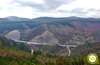
Once again we must face a new stretch of soft but tireless ascent with the imposing silhouette of an elevated viaduct, towards which we are heading.

Almost without realizing it we arrive at the sign that announces the beginning of the following population, although to arrive at it we still have a good stretch.

As it could not be otherwise the road leads us without possibility to error until we finally introduce in Vega de Valcarce (3h 45min).
The French Way continues its advance through the locality, leaving behind us the streets that go into the town.

Little by little the long route through Vega de Valcarce comes to an end watched over by the ruins of the castle that once dominated the region.

Once again we see ourselves climbing up the road surrounded by vegetation and with the unmistakable silhouette of the dual carriageway viaducts on the horizon.

The river Valcarce continues to be the inseparable companion that marks out the path to follow, taking us once again to the meeting of the national road to resume its course.

Without hard shoulders our walk takes us quickly to the shelter of Ruitelán (4h 20min), to which we arrive without further detours.
We follow the road that takes us quickly out of Ruitelán to walk towards a demanding ramp that extends to take us undoubtedly to the sign indicating the next town we will pass.

Once again this indicator deceives us in part because we still have a steep stretch to get to the town centre.

The road advances between solitary buildings until it is time to abandon it definitively when we find a local road that descends to our left while the one we arrive here continues its ascent.

Once again we lose part of the height heading towards the river that we will cross thanks to the Roman bridge that still does its function today. The road takes us directly to Las Herrerías (4h 40min), which we reach without deviating from it.
We still have a short route following the asphalt that will continue to guide us on the route we travel.

The town stretches along the road, but soon the houses give way again to the fields of pastures.

The junction with the road that leads to San Xulian, which we leave on our left to go straight on, is the prelude to our arrival at the town of Hospital (4h 50min), next to the one we have just left behind.

The route crosses this small town without giving us many options to make a mistake.

Just at the end of the town we leave again to our left a road that this time leads to Lindoso, to follow the course that takes us to the nearby river.

As soon as you cross the bridge over the river, the road turns to the left to recover its ascending course, beginning a more pronounced ascent. This long stretch of narrow road without verge begins to show us clearly the hard ascent that awaits us from here until the end of the stage.

The itinerary follows the road at all times leaving to the left and right the trails and paths with which it meets.

Almost hidden by the vegetation, but well signposted by the characteristic stone markers that from now on we have to find, we will see the beginning of the path by which we will face, now yes, the true ascent to O Cebreiro. Cyclists, given the state of part of the route and the unevenness that in some sections is saved, it is better to continue along the road, thus avoiding in most cases having to set foot to land carrying the bike.

This first part of the wide trail gives us a little respite, making us descend for a moment, and then asking us again for continuity with the effort we were bringing. For now the route does not show all its exigency and bad state, allowing us to advance with relative comfort next to the small stream that runs down the valley.

Immediately after crossing the stream, the footpath turns abruptly to draw the typical zetas that help us to save the unevenness in front of us. The firm, quite cobbled and not in very good condition, meanders through the forest whose shade protects us along the route.

The footpath on which we walk, although sometimes quite covered by the leaves that fall from the trees, is well defined and leaves no room for doubt as to the path to follow in the few intersections with which we find ourselves.

We continue encased by a slope of earth and the small wall of stones that marks the limits of the path, which continues to require a strong effort that adds to its not very good condition.

To our left, the fields of cultivation begin to gain protagonism to the leafy forest, moment in which the path for which we are going to turn radically to the right heading towards the first buildings of the following locality that already are left to intuit between the vegetation and leaving behind the path that follows straight.

The cement replaces the track of earth, mud and stones that brought us here and now marks the course that continues the ascent embedded between the walls of the first houses of this town.

The route takes us directly to the wall of a house where it continues to turn left to take us definitively until the interior of La Faba (5h 55min), where we find the entrance road to the town.

Cyclists on their way up the road will encounter the detour that will bring them, if necessary, to La Faba. If this is not the case, it is better to follow the ascent on the road, as the road to Laguna de Castilla is still not in good condition in any of its sections. When we meet the asphalt of the road we will again have to follow the course on the left that marks the asphalt.

We quickly find ourselves at a new crossroads where we must continue straight ahead, leaving the asphalt once again and returning to whitish cement.

We continue still between the houses leaving to both sides the accesses to paths and alleys, to find ourselves in the outskirts of the locality with a new crossroads.

The cement gives way to the dirt road that will take us to the next locality. The trees that gave us the pleasant shade at the beginning of the ascent gradually give way to every metre we climb the fields and bushes, allowing us to contemplate magnificent panoramic views of both what lies ahead and what has been going on until now.

The slope and the bad state of part of the road make us advance slowly leaving to the left and right the trails and paths that enter the fields.

The slope seems to give us a break allowing us to sense the penultimate locality of the day, we soon arrive at a new crossroads where we continue straight ahead leaving behind us the paths that join our own.

Almost without time to recover the route returns to gain height, taking us to pass next to a track that we will leave to the left to continue straight towards the nearest town.

The track that runs embedded between the walls of the fields that surround us, goes towards the town, to continue its run between the first houses that receive us.

The route now with a good cement pavement splits in two, being the option of the left by which we must follow.

This option will take us directly to the nearby road where we will be joined by cyclists who did not venture with this route up to Laguna de Castilla (7h 00min).

Once again the road leads us through the houses of the urban nucleus taking us out quickly him.

As soon as we leave the village, we leave on our left a first path that seems to precipitate towards the bottom of the valley, to continue a few metres further along the road. Shortly afterwards, we find the beginning of the path we must continue along.

Cyclists can now continue along the same route because although there is still some ascent and some sections are somewhat decomposed would not have to be a problem for someone who has come here from so far.

We leave the road to follow the ascent among the bushes that already dominate the whole landscape, with our objective every time closer. We follow this track without deviating from the paths that come to greet us.

The unmistakable milestone that marks the so desired entrance to Galicia, also indicates the proximity of the final point of the stage. We continue the ascent without deviating from the well-defined track on which we are going and which gives us some ramp of a certain magnitude that reminds us that we continue with the ascent to O Cebreiro.

A wall of stones indicates us the relative proximity of the end of the day leading us in the last steps of the ascent.

The route goes out to the road that borders the town, making us follow it a few meters along the paved andadero that will serve as a guide.

Shortly after crossing the road we come across stairs that allow us to cross the stone wall that borders the road.

We can also continue straight ahead because a few meters we will find the entrance street that will take us to the interior of O Cebreiro (8h 05min), just at the doors of the church of Santa Maria where this mythical stage ends.
 Distance. 28Km
If for any reason we have to follow the road section to ascend to O Cebreiro, we will have to add the additional distance.
 Time. 8:05h
Provided that we do not have to deviate because of the state of the route in the final stretch, in which case we must depart their distance. The first part of the stage allows us to advance with a certain speed in order to face the ascent with the necessary calm that this type of routes require.
 Time of year
In winter it is very common to find snow on the route and this makes orientation difficult, forcing us in many cases to follow the course of the road to avoid problems, on the other hand the landscape becomes spectacular compensating the added effort. The rest of the year it offers us a great variety of colors that will make us of a hard and demanding stage, an entertaining and pleasant stage to cross.
 Material required
The boots at the end of the tour are very necessary given the type of terrain and its condition, we must not forget that we return to the mountains so the appropriate equipment for the time of year and weather conditions must add for example warm clothing and rain, as weather conditions can vary quickly. It is not too much to carry some reflective that will help us to be seen in the sections of road, in addition although they are not few the localities that we cross and neither they have much distance between them the food and the water cannot lack us in the backpack. It is not superfluous to carry a map with the route and of course the camera, sunglasses and sunscreen that together with the canes will be useful. Consult our list of material and equipment to make the Way. Read more
 Difficulty. High
Physical
Very demanding stage in the physical not so much for the distance but for the unevenness to overcome, especially in the final part of the course. The apparent comfort and false plain of the first part of the stage should not make us fall into the trap of spending too much energy maintaining a high rhythm to arrive as soon as possible at the beginning of the ascent to O Cebreiro. Calmly and being aware that the ascent begins from Villafranca del Bierzo we can face this route with guarantees and without major difficulties for someone prepared and who already has so many stages in his legs. The final stretch, without shade in summer, becomes hard if we arrive well into the day, so today more than ever it is advisable to get up a little early to avoid the early hours of the afternoon. The whole approach changes if we find snow on the route, the demand is multiplied a lot and we should consider dividing the stage given the extra effort to go making coal in the snow and the extra miles we will have to do to follow the layout of the road that cyclists follow.
Caution
The always dangerous sections of road are multiplied in this stage, adding the continuous crossings of the national that we will have to assume in the first kilometers. The section of road that goes from Las Herrerías to the detour towards the ascent path to O Cebreiro is used by a large number of vehicles that travel along the apparently quiet road. Being a route in part of mountain we should not underestimate the stage nor in the physical thing, we have to be well prepared and without physical problems, neither in the meteorological thing the time varies quickly and with snow or thick fog it is better to follow the road not to look for unnecessary problems.
Orientation
Generally well signposted, with the added advantage of following the route marked by the road for many kilometres, we should not have any problems. It is true that there are many towns we pass through, but in general the Way crosses them without detours. The path, because of its vegetation, is where the greatest complications can be found since it can cover some sign, but on the other hand, the well-defined course of the wide path does not leave many possibilities for confusion, provided we do not have snow or fog, in that case it is more advisable to follow the road that leads to the same O Cebreiro.
 |
 |
 |
 |
 |
| 1-Villafranca del Bierzo | 0:00h | 505m | 0Km | 29T 679573 4719378 |
| 2-Pereje | 1:10h | 545m | 5.2Km | 29T 676791 4721550 |
| 3-Trabadelo | 2:05h | 572m | 9.7Km | 29T 673641 4724059 |
| 4-La Portela de Valcarce | 3:05h | 603m | 13.8Km | 29T 670438 4725151 |
| 5-Ambasmestas | 3:20h | 612m | 14.9Km | 29T 669746 4725777 |
| 6-Vega de Valcarce | 3:45h | 633m | 16.5Km | 29T 668333 4725669 |
| 7-Ruitelán | 4:20h | 661m | 18.7Km | 29T 666547 4726492 |
| 8-Las Herrerías | 4:40h | 676m | 20.1Km | 29T 665376 4726208 |
| 9-Hospital | 4:50h | 687m | 20.9Km | 29T 664711 4726439 |
| 10-La Faba | 5:55h | 923m | 23.5Km | 29T 663054 4727754 |
| 11-Laguna de Castilla | 7:00h | 1167m | 25.8Km | 29T 662003 4729541 |
| 12-O Cebreiro | 8:05h | 1302m | 28Km | 29T 660213 4730238 |
Coordinates UTM Datum WGS84

 Slope acumulate: 1372m
 Slope positive: 1085m
 Slope negative: 287m
 Maximum altitude: 1302m
 Minimum altitude: 493m

This sketch of the route is not made to scale nor does it contain all the information relating to the area, it is merely indicative.

![]()
This schematic with the path is approximate and has been created from the derived cartographic base © Instituto Geográfico Nacional "Cuadrante158, 157, 125 y 126. 1:50.000".
Senditur has manipulated the tracks to correct the aberrant points that may exist, caused by problems with the reception of the GPS signal. In any case the tracks are always approximate. SENDITUR encourages you to use the new technologies within your reach, using them as support and consultation in your activity, not basing the realization and orientation of the same only and exclusively on them, since they may see their functioning altered by very diverse causes, not functioning correctly and their indications may not be precise.


Es cierto que esta etapa no es fácil, pero se puede hacer sin problemas, y llegar a O Cebreiro compensa con creces el cansancio y las horas de caminata. Es una etapa hermosa que te queda para siempre en el recuerdo.

Sin duda una de las etapas que más te marcan en el Camino., de las que sigues recordando tiempo después.

Benedictine monastery and Royal Palace of the Leonese monarchy


Castle of the Templars, the most representative construction of Ponferrada


Find out what to see in...
¿Did you know that...
Don Elías Valiña, parish priest of O Cebreiro until his death in 1989, was the forerunner and creator of the typical yellow arrows that we find marking the course along the whole Way of Saint James, being one of the participants of the resurgence of the route in these years.
Don't miss out...
The castle of Sarracín, in vega de Valcarce, from this locality starts a nice route, among chestnut trees, of scarce 20 min, that takes us in a soft ascent until the ruins of the castle that dates according to some sources of the X century being attributed to the Knights Templar.


From the commitment of SENDITUR with Nature and the respect to the balance of the environment, SENDITUR urges you to travel in a responsible way, with low environmental impact and respecting at all times the Natural, Cultural and Social environment wherever you go.

Besides sharing with all of us your experience on the route we would be grateful if you could write to us to inform us of any erroneous or outdated information you may have found, or simply to let us know what you think at Thank you.
This route has been carried out in the field by SENDITUR on 04-10-2018. The route may vary greatly depending on the time of year, weather conditions and terrain, as well as the actions of third parties and the evolution suffered in the natural environment where it is located. All opinions, advice and/or assessments made by SENDITUR in their descriptions are for guidance only and are subject to and/or refer to the specific conditions of the specific day of the route, referring to that specific day, taken from trained people, with the appropriate experience and with a high level of physical and technical preparation as a reference, as well as correctly equipped.
All the times are approximate and take an orientative character, the stops have not been taken into account, no matter how small they are. All the information related to the route, texts, images, videos, maps, diagrams, tracks, towns, and places of tourist interest are published as a guide, and may not coincide with the current state of each place. Before undertaking any activity, assess your technical knowledge, your physical condition, find out about the weather and the variations that the route may undergo, equip yourself correctly, be prudent and responsible at all times, and do not exceed your capabilities. SENDITUR is not responsible for any misuse or inappropriate use of the comprehensive guides of its routes and/or publications as well as its electronic guides, nor for any variations in their descriptions for the aforementioned reasons, and recommends that everyone be responsible and prudent in carrying out the activity. We also encourage you to read books and specialised guides to complement the information described above.
Continue watching …
 Previous: Stage 21 Ponferrada-Villafranca del Bierzo
 Next: Stage 23 O Cebreiro-Triacastela