Welcome to SENDITUR.COM · paths · routes · tourism

![]() Difficulty-Moderate
Difficulty-Moderate
![]() 3:10 h.
3:10 h.
![]() 10.7 km.
10.7 km.
![]() Difficulty-Moderate
Difficulty-Moderate
![]() 3:10 h.
3:10 h.
![]() 10.7 km.
10.7 km.
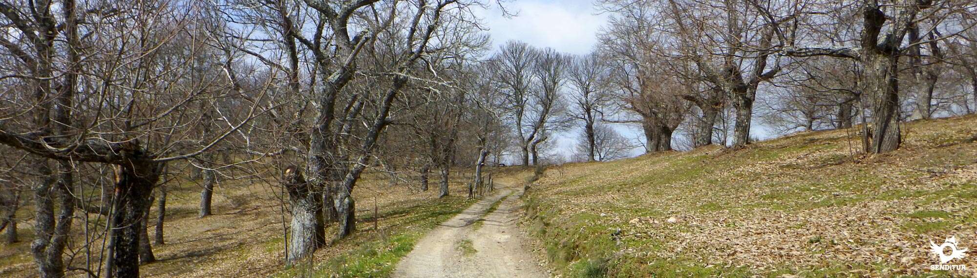
The Galaico-Leones massif forms part of this route that starts from Villafranca del Bierzo, at the gates of Los Ancares and transports us along the shoulders of the mountains to precipitate into the deep valley where Trabadelo is located, a meeting point with the original route of the Way of Saint James. The hundred-year-old oaks and the magnificent panoramic views of the Bierzo valley first and then the Valcarce valley are well worth the effort that this mountain route requires of us.

The stage 22b Variante de Pradela of the French Way with 10,7 Km starts from Villafranca del Bierzo, just before arriving at the Convent of La Concepción, to undertake a worked ascent that will elevate us above the valley allowing us to contemplate what in previous stages we have been leaving behind us. The mountains that surround us extend around us letting us intuit part of the landscape that awaits us in not so distant kilometers. The characteristic vegetation of the area, dotted with oaks and chestnut trees that surprise us with their colossal trunks, gives way to the rounded and uninhabited peaks that force us to save their elongated slopes.

There are many trails and paths that cross this small mountain range which we cross from side to side following the valley that forms the river Valcarce. Pradela and its green meadows receive us for an instant just before we precipitate towards the bottom of the deep valley that ran under our feet. This small village offers us all its hospitality inviting us to visit it, since the route leaves it to one side in its impassible advance, to recover forces before continuing with our trip. The rapid descent takes us directly to the valley where, as if in veins, viaducts run where the highway runs.

Trabadelo, which we had been able to contemplate before, is now more accessible, forcing us to go back a few meters to reach its doors. The temple of San Nicolás and its slender belfry welcome us on our arrival at Trabadelo, where we will meet again with the companions who followed the original route of the French Way to continue together towards the next milestone of the route which in our privileged itinerary we could already sense on the horizon.
According to legend, in the surroundings of Pradela you can hear the sound of a bagpipe played by an unmistakable sorcerer who lives in the area. It can be easily recognized because it is as high as the tallest tree, its clothes are made of tree bark, its beard is made of moss, its hair of leafy and green vegetation and it is always accompanied by its inseparable bagpipe with which it intones soft melodies that make the grass and the trees grow. It is said that the days of storm and strong wind is the sorcerer that shows his anger making sound with force his bagpipe showing us his discontent with the treatment we give to the land where we live.
This is a physically demanding route, which may be more demanding depending on the weather conditions, as it will not have much shade to shelter in, nor water points to cool down in, so it is important to control and dose your efforts.
The absence of fountains and localities along the entire route obliges us more than ever to be forward-thinking and bring enough water and food that we might need. We always have the option of approaching Pradela if necessary, but we cannot count on finding the services we need open.
The route avoids us as usual to meet with the cattle, except to the arrival to Trabadelo where we will pass next to a farm. It goes without saying that in both localities and in nearby Pradela is where we can find some dog that surely this campando to its wide by the proximities.
As soon as you cross the bridge over the Burbia River in Villafranca del Bierzo (0h 00min), you will come across the detour that will take you to Trabadelo via the Pradela Variant.

The route bids farewell to the layout of the French Way that continues straight on to continue along the Pradela Way, which makes the steep ascent that awaits us ahead very clear from the start.

This battered street makes us gain height quickly without giving us any respite that allows us to catch air and contemplate the breathtaking views that the highest height offers us of Villafranca del Bierzo.

We advance little by little leaving behind us the few houses and streets that mark the limits of the town and that give way to a cobbled mountain road.

The demanding path makes us continue ascending, forcing us to progress calmly and making it clear to us the need to be well prepared physically to face this route that adds effort to legs with many kilometers.

The cobbled road is surrounded by the exuberant vegetation that populates the slopes of these mountains, embedded between stone walls and slopes that mark their limits.

On the rare occasions when the slope loses part of its inclination, we take advantage of the opportunity to recover our strength and enjoy the impressive panoramic views that this route offers. We pass by some imposing high-voltage towers that support the electric line that we will cross on more than one occasion.

The route introduces us into a leafy forest that gives us a wonderful freshness that together with the best state of the road and the slightest inclination of it allows us to enjoy this beautiful route.

After a while we come to the first remarkable crossroads of the route in which our path goes straight on regardless of the route we crossed. The physical difficulty and accessibility in case of problems has influenced in the disappearance of the marks that indicated the route to follow in some of the crossings through which we will pass, fortunately in the great majority we will not have to deviate.

The track continues to make us gain height by cutting the slope of the mountain that no longer gives us shade to protect us, in summer, from the relentless sun.

To our left we leave some roads that precipitate down the slope in search of the valley through which the motorway and the original route of the Way of Saint James runs. We continue advancing regardless of how many detour options we can find, the route, and smoother, continues to make us leave behind the hills that observe us on our right.

A new electric line with its high towers crosses in our way at the same time that we cross a new crossing in which once again we continue straight without deviating from our trajectory.

The deceitful profile makes us gain height to save one hill after another making us think that the one we are ascending will be the last one, until we reach its highest part and we find another hill to cross.

High-voltage towers and solitary antennas at the top of a hill can serve as a reference in case of doubt at any of the crossroads with which we are encountering. In no case will we have to abandon the course we have followed until now.

The route takes us to pass halfway up the hill where the antennas are located, leaving the antennas and the path that goes up to them. We can sense that this is the end of the ascent we had to make. Beginning a part of the route much more comfortable but somewhat undulating.

The trees take possession of the land little by little without hiding the landscape that surrounds us but giving us part of their shade and serving us as company in this solitary stage.

The route continues to take us without detours at the few junctions with which we find ourselves in a gentle descent that allows us to progress faster.

Our track is almost cut by a stone wall in which we have to deviate, because if we follow the track on the right, which seems to continue with the straight run that brought us here, we would go to the village of Pradela. If we follow this option, we won't have to detour any further until we reach the village. Once there, follow the road that leads to Trabadelo.

We must turn to the left to return to the lost course leaving behind another road that reaches this crossroads parallel to the one that brought us here.

Saved this, for now, only detour of the itinerary we head for a new section surrounded by fields plagued by trees that maintain the appearance of the landscape we have been walking for some time. Once again we must continue on, without deviating at any time, following the main track delimited in certain sections by a wire fence.

Our track arrives at a new crossroads at which several paths converge, at which point we change course, turning to our right to leave the other paths we have encountered on both sides.

A relatively short stretch awaits us between meadows of pastures that will take us directly to the meeting of the road that ascends from Trabadelo towards the nearby Pradela.

When you reach your height the route turns left to follow the course of the asphalt leaving behind the small village of Pradela. Pilgrims who decided at the first detour to follow the track that led to Pradela will join us at this point to undertake together the rapid descent that awaits us.

We must travel a stretch on the asphalt of the road. At the moment we do not have to deviate in the crossroads that we find ourselves.

Shortly after entering among the trees that have gained protagonism again, at the end of the guardrail that accompanies us to our right, we find ourselves with the beginning of the path by which we must continue.

This track puts us fully into a steep descent thus avoiding us to follow the course of the road that turns in that place to the left, away from us in search of the best place to continue descending.

This section takes us over the shoulder of the mountain without letting us leave the drawing that traces the track we are going.

There are quite a few trails and paths that we leave behind heading towards another imposing high-voltage tower next to which the route passes after making us meander along the slope avoiding part of its steep slope. The valley, which is getting closer and closer, awaits us at the end of the descent, of which we still have a long way to go.

The road crosses with us again, making us follow it a few meters until we reach the beginning of the track that we have to continue descending.

Once again, almost in the middle of a curve, we began a vertiginous descent along a cobbled road that makes us change direction repeatedly.

After a strong ramp, in one of its changes of orientation, we find a track that joins us on our right. Together we head towards the bottom of the valley, where Trabadelo awaits us.

The road interposes itself again in our advance, making us go up a few meters its course to continue with the descent following the track that starts on the other side.

This part descends again with force introducing us in a leafy forest that hides again the end of the stage.

This muddy path takes us to the gates of the locality, making us turn sharply again to go to their first houses, leaving behind some stables.

The descent does not end and continues forcing us to lose altitude without allowing us to follow the streets that lead to the church that receives us on our arrival to the town.

At the moment we find the end of the long descent and the street through which we arrived, when it meets the street Camino de Santiago de Trabadelo (3h 25min), which as its name indicates is where we join the original layout of the French Way, where this variant ends.
 Distance. 10,7Km
To this figure we will have to add the distance that separates us from our actual stage end point.
 Time. 3:10h
As it cannot be otherwise the ascent supposes us the greater part of the time that we will need to realize this route, to whic:if we approac:Pradela we will have to add the scarce kilometer that we cross of more and that adds 15min approximately to the total time.
 Time of year
The route takes us away from the valley where the original stage takes place, offering us unsurpassable panoramic views of the environment that surrounds us. The landscape is enhanced by the imposing chestnut and oak trees that populate the slopes we cross. The solitude, habitual for the pilgrims who decide to carry out this variant, is an addition that is added to the charms that the route offers. Winter or bad weather, fog, rain or snow not only make it unwise to undertake suc:a route but also deprive us of any panoramic view that is one of the main attractions of the route.
 Required equipment
Half mountain tour that forces us to equip ourselves wit:the appropriate material, boots, warm clothes, raincoat, canes, water, food, front, telephone wit:batteries and the map of the area along wit:the explanation of the route or failing that the GPS wit:the tracks can not be missing in this solitary stage. Of course the camera, sunscreen and sunglasses next to the head cap are good companions that if we do not accompany to good sure we will miss them. Consult our list of material and equipment to make the Way. Read more
 Difficulty. Moderate
Physical
The strong ramps that we have to overcome make this route physically demanding, althoug:it is true that by itself is not a great challenge for a person accustomed to this type of terrain, it is very important to take into account not only the kilometers that we already carry in our legs but also that the route will undoubtedly be part of a major stage, conditioning bot:facts the requirement of a layout already strong. We must calmly assess the suitability of including it in our Way and be very aware of our physical and technical possibilities before venturing to do so.
Caution
We should not even consider taking this route in the event of fog, bad weather or snow, its layout and the difficulties of communication and access for emergency services in the event of problems make it totally unadvisable in these cases. We will also have to worry that we do not lack the water and some food because throughout the route we will not pass throug:any town and Pradela we are almost at the end of it and away from the normal route. The descent is another of the points to take into account, not because of the state of the loose stone surface, but because of its inclination, whic:can make our joints suffer more than they should.
Orientation
Unfortunately the layout has fallen into a certain carelessness, disappearing part of the marks that signaled it, either because of wear or because they have been withdrawn to prevent pilgrims follow it without knowing perfectly what they are getting into. This fact is caused in part by disinformation, the undervaluation of the route or the overvaluation of physical conditions and technical experience, whic:if necessary is possessed and that some pilgrims do not consider at the time of venturing to travel certain sections, encountering real problems that have come to cause personal misfortune. For that reason to the different conditioning factors that we must take into account before deciding for this route we must add at least a map of the zone wit:the route well clear or a GPS wit:the tracks introduced that can serve us of help in case of doubt. It is true that althoug:it is easy to get lost, the route does not have large detours and follows a well-defined track that still has some marks somewhat less visible than normal, whic:will help us to follow it provided that weather conditions are appropriate and these marks and roads are not covered for example by snow.
 |
 |
 |
 |
 |
| 1-Villafranca Del Bierzo | 0:00h | 505m | 0Km | 29T 679472 4719764 |
| 2-Trabadelo | 3:10h | 572m | 10.7Km | 29T 673742 4724048 |
Coordinates UTM Datum WGS84

 Slope: 893m
 Slope +: 479m
 Slope -: 414m
 Maximum altitude: 931m
 Minimum altitude: 507m

This sketc:of the route is not made to scale nor does it contain all the information relating to the area, it is merely indicative.

![]()
This schematic wit:the pat:is approximate and has been created from the derived cartographic base © Instituto Geográfico Nacional "Cuadrante 157 y 158 1:50.000".
Senditur has manipulated the tracks to correct the aberrant points that may exist, caused by problems wit:the reception of the GPS signal. In any case the tracks are always approximate. SENDITUR encourages you to use the new technologies within your reach, using them as support and consultation in your activity, not basing the realization and orientation of the same only and exclusively on them, since they may see their functioning altered by very diverse causes, not functioning correctly and their indications may not be precise.


Una preciosa variante, aunque muy exigente, variante de esta etapa del Camino. Merecio la pena el esfuerzo

Benedictine monastery and Royal Palace of the Leonese monarchy


Castle of the Templars, the most representative construction of Ponferrada


¿Did you know that...
Every first of May the Festa do maio is celebrated in Villafranca del Bierzo, where people dressed in branches and flowers that represent how nature comes to life, leave each neighbourhood of the village asking the neighbours for chestnuts and singing a song with which they reward their generosity or stinginess.
Don't miss out...
A visit to the monumental town of Villafranca del Bierzo, a historic town with a large and well-preserved historic-artistic complex made up of a large number of palaces and religious buildings which, together with its characteristic castle, bear witness to the importance this town has had over the years.


From the commitment of SENDITUR with Nature and the respect to the balance of the environment, SENDITUR urges you to travel in a responsible way, with low environmental impact and respecting at all times the Natural, Cultural and Social environment wherever you go.

Besides sharing with all of us your experience on the route we would be grateful if you could write to us to inform us of any erroneous or outdated information you may have found, or simply to let us know what you think at Thank you.
This route has been carried out in the field by SENDITUR on 05-10-2018. The route may vary greatly depending on the time of year, weather conditions and terrain, as well as the actions of third parties and the evolution suffered in the natural environment where it is located. All opinions, advice and/or assessments made by SENDITUR in their descriptions are for guidance only and are subject to and/or refer to the specific conditions of the specific day of the route, referring to that specific day, taken from trained people, with the appropriate experience and with a high level of physical and technical preparation as a reference, as well as correctly equipped.
All the times are approximate and take an orientative character, the stops have not been taken into account, no matter how small they are. All the information related to the route, texts, images, videos, maps, diagrams, tracks, towns, and places of tourist interest are published as a guide, and may not coincide with the current state of each place. Before undertaking any activity, assess your technical knowledge, your physical condition, find out about the weather and the variations that the route may undergo, equip yourself correctly, be prudent and responsible at all times, and do not exceed your capabilities. SENDITUR is not responsible for any misuse or inappropriate use of the comprehensive guides of its routes and/or publications as well as its electronic guides, nor for any variations in their descriptions for the aforementioned reasons, and recommends that everyone be responsible and prudent in carrying out the activity. We also encourage you to read books and specialised guides to complement the information described above.
Continue watching …


 Previous: Stage 21 Ponferrada-Villafranca del Bierzo
 Next: Stage 22 Villafranca del Bierzo-O Cebreiro


