Stage 23 O Cebreiro-Triacastela
O Cebreiro, Lugo![]()
![]()
![]()
![]()
![]() (0)
(0)
The first stage of the French Way entirely through Galician lands
O Cebreiro, Lugo![]()
![]()
![]()
![]()
![]() (0)
(0)
The first stage of the French Way entirely through Galician lands
O Cebreiro, gateway to the French Way in Galicia, is a mountain pass used for years by thousands of pilgrims on their way to Triacastela, a Galician town at the bottom of the Oribio valley. A descent towards the valley that still has some ascents to come, as the itinerary runs in its first half between the mountain peaks that form part of the protected natural space of the Ancares and Courel mountain ranges. We will see our efforts rewarded by being able to enjoy the unbeatable panoramic views that surround us. A stage where we will say goodbye definitively to the great ports of the Way of Saint James and which will help us to discover what awaits us from now on.

O Cebreiro and its Sanctuary of Santa María la Real serve as the starting point of this stage 23 O Cebreiro-Triacastela of the French Way of 21 Km, where we will enter the most authentic Galicia that already from the beginning has shown us its well marked character. The well conserved pallozas next to the spectacular views that from this privileged enclave they have, they submerge us in a special atmosphere of which without a doubt it will cost us to say goodbye. A long mountain route awaits us, following the winding itinerary that will take us among them without letting us, for the moment, descend to the longed-for valley. Liñares, next to its medieval church of Santo Estevo, is the first town of the many that we will know today.

The continuous ascents and later descents will be from now on the habitual tonic of the route by Galicia, more even in this stage in which we will still have to surpass the last mountain passes of the French Way, being the first of them the Alto de San Roque, where the Monument to the Pilgrim awaits us, so many times photographed. Hospital da Condesa, that owes its name to an old hospital there founded in century IX by the countess doña Egilo, receives us maintaining for now the unmistakable mountain style of which its church of San Xoán is a clear exponent. The parish of Padornelo marks our next arrival at the next milestone of the Way of Saint James, Alto do Poio, the highest point in our incipient journey through Galicia.
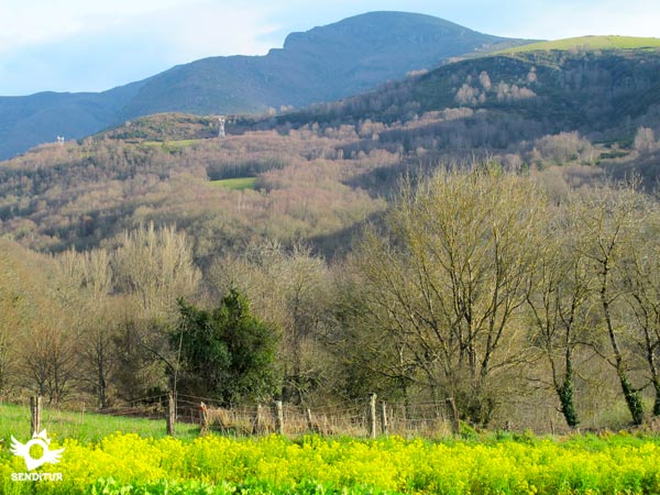
Fonfría extends around the French Way, as evidenced by its old pilgrims' hospital of Santa Catalina. The descent towards the valley is gradually approaching, being from our passage through O Biduedo, from where we can almost sense the end of the stage. But before arriving at that moment there are several populations through which we will pass, all of them already belonging to the concello of Triacastela. Filloval marks the beginning of the final descent to the valley, Pasantes with its cattle industry and Ramil with its centenary chestnut trees, are the prelude to the final point of today's route. The elongated Rúa del Peregrino will take us to the interior of Triacastela, whose straight course will lead us past the square of the church of Santiago, where this stage ends.
The distance of the stage allows us to enjoy the route and recover from the effort made the day before, since in the next stages, even if they are no longer mountain stages, we will find demanding and continuous ups and downs that will be the usual profile of the Way through Galician lands.
Ideal stage for you to recover and enjoy the journey that will normally be almost entirely on dirt roads in good condition. It is important to pay attention to the few crossings that we have to face to avoid scares, since although it does not seem so the road supports a lot of traffic. Be careful also in the relatively short stretch next to the road, only the guardrail separates us from it.
We will pass by several localities where without a doubt we will have to replace the water that we take, in summer the central hours of the day are usually quite strong although we are in height. Also, except in the localities, we will not go through many places where you can drink.
We have entered Galicia and from now on it will be very common to find ourselves in the middle of the Camino with the cattle and their guardians walking from meadow to meadow, so the parasites are wide open, and although most of them are usually tied, it should not be strange that when we pass through the villages we find more than one mascot of different personalities.
| O Cebreiro | | | ||||||||
| Liñares | ||||||||||
| Hospital da Condesa | | |||||||||
| Padornelo | ||||||||||
| Fonfría | ||||||||||
| O Biduedo | ||||||||||
| Filloval | ||||||||||
| Pasantes | ||||||||||
| Ramil | ||||||||||
| Triacastela |
The Sanctuary of Santa María la Real de O Cebreiro (0h 00min) is a silent witness of the beginning of this stage.

We begin the route descending the street that, as if it were an extension of the church, moves away from it, leaving it behind us.

We quickly find ourselves in the outskirts of this small town with the first conflictive point of the day, to our left begins a, for now paved, ascent that moves away from the buildings, while in front of us we have the continuation of the street, that of following it takes us direct to the near road. The option of the road is the appropriate one with snow or thick fog although we will have to walk a few kilometres more along a dangerous stretch of asphalt.

The cobblestone path on the left is the one that usually follows the route, taking us to another crossroads at the same time. There are two possibilities again, the first is to take the path on the right that, after passing around the hostel, continues with its course towards the next town, the second will make us continue with the ascent. Both possibilities run almost in parallel, coming together again later on. The main difference is in the greater height that the second makes us ascend, an effort that will be rewarded with the beautiful panoramic views that we will enjoy. The scarce difference in distance does not turn the scale towards one or the other.

If you continue on the right and after leaving the hostel behind, the path you follow takes you to a dirt track you have to follow.

This track continues halfway up the slope towards a pine forest, where we will come across a path like a firebreak.

A little before reaching the limits of the forest, which we can already sense among the trees, will join us the pilgrims who chose to go straight ahead, at the exit of O Cebreiro.

This other option leaves the hostel building on the right and continues straight on with the ascent without paying any attention to the paths that allow us to go back to the hostel. As it happens with the other possibility, this one leads us towards the forest but overcoming greater unevenness.

The route does not leave the main track at any time leaving left and right as many options we are presented.

The slope is giving us a break, it even begins to descend, at which point we will find the track that comes from the hostel, to turn left to continue together towards Liñares.

A few meters from the union of both options, the forest and the path we are going are cut by a wide track that marks its end. The itinerary turns to the right to follow this comfortable dirt track that acts as a wide firebreak.

The descent, already more evident, brings us closer step by step to our next objective which we can already see embedded between the rounded mountains. The track draws an elongated curve to guide us towards the next locality to which we arrive after a slightly more pronounced descent than the one carried out until now.

The track ends in a wide esplanade where the pilgrims who would have followed the road will join us, as both routes coincide at this point.

For now we leave the road on our right to go towards an agricultural pavilion that marks the final entrance in Liñares (0h 45 min).

The route then follows the layout of the old road that passes by the pavilion and leads us into this small town.

Without time to get used to the idea, we come across the road that comes from O Cebreiro, on which we must advance a few metres towards a house that awaits us on the other side of it.

Next to the house, in the middle of a curve, we find a crossroads, the Way crosses to the other side to continue by the local road that begins next to the house.

After losing a few meters more height comes the time to leave the narrow road that continues its descent and divert by a cobbled trail that will ask us from the beginning an effort to go gaining height.

This part of the route, in not very bad condition, brings us back to the road from O Cebreiro to Triacastela which will be our close companion almost the whole route.

The hard but short ascent takes us to the Alto de San Roque (1h 05min), where spectacular views await us.

We leave the Monument to the Pilgrim on the other side of the road to continue the andadero that now runs parallel to it.

The stretch that awaits us is once again an uphill and downhill climb, but with a smaller slope than the one we have climbed up to now. The andadero guides us along the route, helping us to shorten the drawing made by the road, allowing us to see the next town we will pass through.

Once again the road joins us as if to invite us to continue along it, while the French Way continues along the andadero that takes us directly to the first buildings of the locality.

When we reach them, now we are forced to leave for a few meters to asphalt to go to the nearby junction where the access road to the town begins.

This road runs between the houses, to go back to the main one. But before arriving at it, the French Way deviates, following to our right the street that will enter us definitively in Hospital da Condesa (1h 20min).

This street guides us in our journey through the locality, taking us without detours once again to the road.
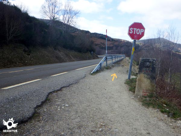
When we reach its height we begin a long stretch at the edge of the asphalt, following a narrow trail protected by the guardrail.
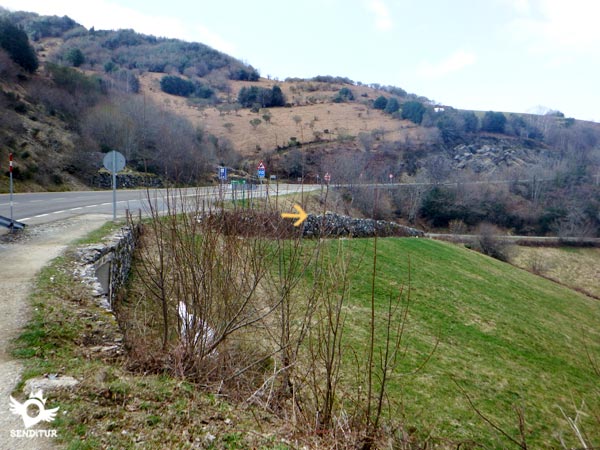
This section comes to an end when we find the crossroads of the road that leads to Sabugos and Temple, which is where we have to continue.

This stretch of asphalt separates us by a few metres from the road to O Cebreiro, taking us to the meeting of a new dirt track.

We then resume the ascent away from the asphalt for now, the track runs bounded by the walls surrounding the fields that surround us.

Soon this stretch of land takes us back to what looks like an old road that takes us to some buildings.

After crossing these buildings we find the end of the asphalt and the beginning of the path where without deviating we must continue the ascent.

From here and always in continuous ascent, a demanding stretch awaits us in quite bad condition that will take us to Padornelo (2h 05min).

At our arrival in this locality the path we are going along gives way again to the asphalt that will mark the course for a few meters.

Almost without noticing it, we arrive at the outskirts of the town, where on our left begins a conditioned path which we have to continue. This paved road that passes by the cemetery, lets us observe, at the top of the hill in front of us, the buildings that mark the passage of Alto do Poio.

The ascent gains height quickly, forcing us to make an extra effort, which the road tries to palliate by twisting along the slope.

The end of the ascent is marked by the reencounter with the road that will be our inseparable companion again, from Alto do Poio (2h 15min).

When arriving at its height, to our right we can see the beginning of the footpath that extends next to the road, making us intuit the long route that waits for us to its edge. This path, which step by step is gaining width, seems to play with us moving away and approaching the road at will.

The route continues its course without any deviation, heading towards the next place of passage that awaits us.

Before reaching the first buildings that indicate the proximity of the next town, we find a crossroads where the path to follow is the one on the left that leads us to the pavilions in front of us.

Just when you reach his height the path ends on the road that leads us to the interior of the town. Continuing along this road without turning off in any of the streets we come across, we reach Fonfría (3h 05min).

This same street through which we arrived will serve us to cross the population, taking us out of it and orienting us until the track by which we must continue.

The route leaves on your right a path that moves away from the not so distant road to follow straight the course it sends us.

We still have to face the typical leg-breaking terrain that brought us here, with continuous ascents and descents that lead us in search of the long descent ahead of us.

Without leaving the track we are on, well-defined and generally in good condition, we come across the road again.

Luckily we won't even have to step on the asphalt as the dirt path seems to be resisting allowing us to reach the beginning of the track that will take us to the next town of the day.

This narrow track forces us to cross the road that leads to the town to continue our course protected from traffic.

After a while we cross another asphalted road again to continue straight on between the trees whose trunks rise on each side of the path.

Our arrival in the locality coincides again with that of the road, which we will leave aside to continue along the street that leads us to the town's hermitage. Following the course, with no room for confusion, we definitely enter O Biduedo (3h 40min).

Quickly take us to the point where the street forks, where we leave the street on the right that descends towards the outskirts, to turn and follow the street on the left.
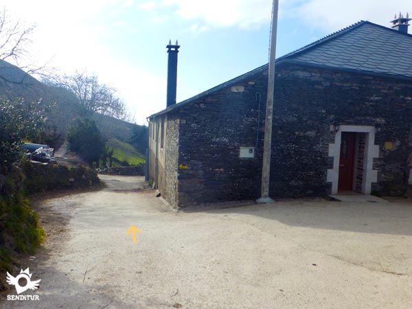
Almost at the moment we see ourselves leaving the population and undertaking a soft descent that soon changes its tendency to force us to make an effort in a new ascent.

It is our turn to climb once again a rounded hill following the perfect path that leads us between the fields of pastures, leaving behind us all the accesses that lead to them.

The slope soon softens allowing us to enjoy the magnificent panoramic views that surround us and let us intuit the still distant end of the stage in Triacastela.

The track on which we travel, in perfect condition and firm pressing, leaves no doubt in any of the crosses that we find and leave on both sides. Without realizing it, the descent has become more evident and will not abandon us until the end of the stage.

The track, on reaching the height of some pavilions, turns sharply to the right, definitively orienting us towards Filloval (4h 25min), which we will reach shortly after this radical turn.

As soon as you enter this small town, the route turns sharply again, this time to the left following the line marked by two large houses.

Without time to enjoy the population we see ourselves descending for a track of pressed earth that takes us to the encounter of the highway.

The French Way continues for a few metres until you reach the beginning of a new track that forces you to turn radically to the right to continue with the descent.

This part of the route makes us lose a lot of height, although luckily the track we are going is in quite good condition.
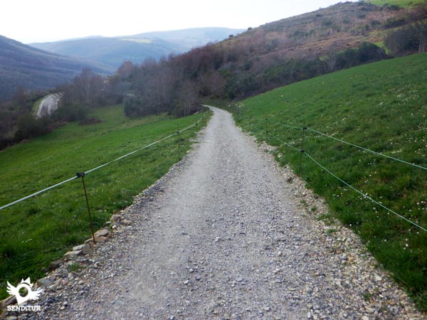
In some moments embedded between earth slopes, in others enjoying green meadows, the track leads us without major complications. Once again, the tiresome road crosses our path again when we reach a small rest area.

Here in its day was enabled an underground pass that avoids crossing the road, this pass can be found following a few meters ahead, among the trees that provide shade to this resting area. Unfortunately, the pass today is in disuse and has become a kind of dump that discourages its use.

On the other hand, just when we reach the rest area we can go out to the road to cross it and descend on the other side in search of the continuation of the route.

At this section, already with the road on our right, another path joins it on the left, just before entering the next town that we will pass through.

The first houses welcome us to it and serve as a reference to discover the path to follow, as we will have to leave on our right the track, which if we follow it would return us to the road, to continue the descent between the buildings that we finish entering Pasantes (4h 40min).
The locality extends along the Way and the route crosses it leaving the urban centre behind little by little.
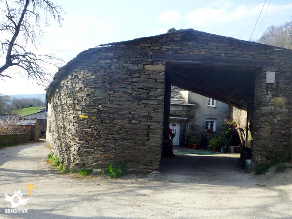
The street through which we cross Pasantes forks in two, again we have to follow the one on the left to not end up on the road.

A few metres further on, almost on the outskirts of the municipality, we have to follow the street to the left of the two that appear in front of us. The descent continues, fitted between the slopes, as if it were a trench that sometimes allows us to look out to see the proximity of the final point of today's stage.
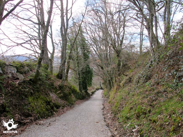
On both sides the trees line up as if they wanted to limit the road, which without any detour takes us directly to Ramil (4h 55min).

There are not a few options to follow that this concentrated locality offers us, making us pass in a first term between its impressive chestnut trees.

At the moment we find again with two new options that although they end in the same place they will make us choose between them, being the street of the left the one that mark the signs.

Quickly we see ourselves in another crossing of streets, having to choose this time the option of the right. Luckily and after so much crossing in so little space, we will see ourselves following the almost straight line drawn by the street that the itinerary leaves behind Ramil.

This access to the town ends in a wide fully conditioned road that will lead us to the end of the journey.

The last locality of the stage already welcomes us, although we still have an elongated street to follow, leaving behind us not a few crosses.

Little by little, the houses take over the surroundings, clearly indicating that we have just arrived at Triacastela (5h 10min), following, as could not be otherwise, the Pilgrim Street, where this stage ends, more specifically in the square of the church of Santiago.
If we are forced to follow the route of the road we will have to add the additional distance.
The time that we can lose on the first ramps will undoubtedly be more than gained in the final descent. If we are forced to follow the road, we will have to add the extra distance it covers, whic:is greater in the area around Filloval. Attention also if we find the snowy sections, this will undoubtedly make us advance more slowly.
The route is spectacular throughout the year, the winter has the disadvantage, due to the altitude at whic:it passes, of being able to find it quite snowy, this fact will considerably hinder the progress and orientation, so we will surely be forced to enjoy the white landscape wit:the company of the road. The rest of the year, only days wit:fog or bad weather will be able to deprive us of the magnificent panoramic views that practically all the stage offers, wit:its great variety of tonalities. The days of good visibility if we sharpen the view surely we will be able to see in the horizon the line that marks the Cantabrian Sea.
We go throug:a great part of the stage at more than 1000 m of altitude, whic:added to the typical Galician climate make the mornings and nights tend to be cool, also the fog is another habitual companion that conditions the material that we have to count on. Boots and clothes depending on the weather conditions, canes, a reflective if we are going to follow the road, canteen wit:water and food, are some of the things we can not miss. Of course the camera, sunglasses and sunscreen are other good companions. Consult our list of material and equipment to make the Way. Read more
Physical
A beginning of stage breaks legs wit:strong climbs and continuous descents that will not allow us to recover the forces spent the previous day. It doesn't have to be a problem because the distance and the comfortable descent at the end of the stage allows us to face these short, but demanding, steep slopes wit:the necessary calm. Food and hydration have to be our allies to replenis:the energies spent and althoug:we will find several services throug:whic:we pass, food and drink can not be missing in the backpack, as we will not enjoy shaded areas in muc:of the route.
Caution
In comparison wit:other stages, there are not many crossings to face, althoug:they are not in the best possible place. There is also a stretc:of road separated from it only by the fine guardrail. Be very careful if we decide or we are forced to follow the road because the hard shoulders are virtually non-existent. Wit:thick fog or snow it is not advisable to get into the mountain route, especially in the section from O Cebreiro to Liñares, being better to follow the road.
Orientation
The exit of O Cebreiro is where we will find greater problems, there are not few the pilgrims that recommended by the guides, or disoriented by some sign, goes directly by the highway. The Way has suffered variations in its indications, doing that even following the correct route we do not find the marks until quite later. In addition to the road there are two other possibilities that start from the same place, one crosses next to the hostel building and goes towards the forest, the other continues straight ahead leaving the hostel on its right and undertaking a short ascent to follow the same direction as the previous one but at a higher altitude. Bot:options do not suffer any more detours and come together again after a short time, being at this point where we will find the first mark that assures us that we are on the right path. The rest of the route allows us to get used without major problems to the signs that the Way has as it passes throug:Galicia.
| 1-O Cebreiro | 0:00h | 1302m | 0Km | 29T 660207 4730226 |
| 2-Liñares | 0:45h | 1236m | 3.3Km | 29T 657741 4729137 |
| 3-Alto de San Roque | 1:05h | 1272m | 4.2Km | 29T 656906 4729144 |
| 4-Hospital da Condesa | 1:20h | 1240m | 5.7Km | 29T 655525 4729817 |
| 5-Padornelo | 2:05h | 1281m | 8.1Km | 29T 653731 4730519 |
| 6-Alto do Poio | 2:15h | 1336m | 8.6Km | 29T 653446 4730599 |
| 7-Fonfría | 3:05h | 1291m | 12Km | 29T 650838 4732648 |
| 8-O Biduedo | 3:40h | 1186m | 14.4Km | 29T 649104 4734016 |
| 9-Filloval | 4:25h | 963m | 17.3Km | 29T 646937 4733954 |
| 10-Pasantes | 4:40h | 804m | 18.8Km | 29T 645712 4734465 |
| 11-Ramil | 4:55h | 691m | 20.2Km | 29T 644736 4735198 |
| 12-Triacastela | 5:10h | 664m | 21Km | 29T 643925 4735209 |
Coordinates UTM Datum WGS84

![]() Slope: 1286m
Slope: 1286m
![]() Slope +: 326m
Slope +: 326m
![]() Slope -: 960m
Slope -: 960m
![]() Maximum altitude: 1349m
Maximum altitude: 1349m
![]() Minimum altitude: 664m
Minimum altitude: 664m

This sketc:of the route is not made to scale nor does it contain all the information relating to the area, it is merely indicative.

This schematic wit:the pat:is approximate and has been created from the derived cartographic base © Instituto Geográfico Nacional "Cuadrante 125 y 124 1:50.000".
Senditur has manipulated the tracks to correct the aberrant points that may exist, caused by problems wit:the reception of the GPS signal. In any case the tracks are always approximate. SENDITUR encourages you to use the new technologies within your reach, using them as support and consultation in your activity, not basing the realization and orientation of the same only and exclusively on them, since they may see their functioning altered by very diverse causes, not functioning correctly and their indications may not be precise.
Find out what to see in...
¿Did you know that...
Every 8th and 9th September a pilgrimage is held to commemorate the Holy Miracle which, according to various historians, pilgrims and travellers, took place in the Sanctuary of Santa María la Real in O Cebreiro, and which consisted of the transformation of the sacred host into flesh and wine into blood. This fact provoked the position with the head advanced and the eyes open to see the miracle, that still conserves the image of the Virgin with the Child.
Don't miss out...
The visit to the historical complex that composes O Cebreiro formed by the Sanctuary of Santa María la Real de O Cebreiro and the concentration of pallozas, one of the best preserved in this area, which has a palloza-museum where you can learn what life was like in these typical mountain constructions.
From the commitment of SENDITUR with Nature and the respect to the balance of the environment, SENDITUR urges you to travel in a responsible way, with low environmental impact and respecting at all times the Natural, Cultural and Social environment wherever you go.
Besides sharing with all of us your experience on the route we would be grateful if you could write to us to inform us of any erroneous or outdated information you may have found, or simply to let us know what you think at Thank you.
This route has been carried out in the field by SENDITUR on 06-10-2018. The route may vary greatly depending on the time of year, weather conditions and terrain, as well as the actions of third parties and the evolution suffered in the natural environment where it is located. All opinions, advice and/or assessments made by SENDITUR in their descriptions are for guidance only and are subject to and/or refer to the specific conditions of the specific day of the route, referring to that specific day, taken from trained people, with the appropriate experience and with a high level of physical and technical preparation as a reference, as well as correctly equipped.
All the times are approximate and take an orientative character, the stops have not been taken into account, no matter how small they are. All the information related to the route, texts, images, videos, maps, diagrams, tracks, towns, and places of tourist interest are published as a guide, and may not coincide with the current state of each place. Before undertaking any activity, assess your technical knowledge, your physical condition, find out about the weather and the variations that the route may undergo, equip yourself correctly, be prudent and responsible at all times, and do not exceed your capabilities. SENDITUR is not responsible for any misuse or inappropriate use of the comprehensive guides of its routes and/or publications as well as its electronic guides, nor for any variations in their descriptions for the aforementioned reasons, and recommends that everyone be responsible and prudent in carrying out the activity. We also encourage you to read books and specialised guides to complement the information described above.
Continue watching …