Welcome to SENDITUR.COM · paths · routes · tourism


Stage 24b Triacastela-Sarria by Samos
Following the course of the Oribio river
![]() Difficulty-Moderate
Difficulty-Moderate
![]() 6:10 h.
6:10 h.
![]() 24.6 km.
24.6 km.
Following the course of the Oribio river
![]() Difficulty-Moderate
Difficulty-Moderate
![]() 6:10 h.
6:10 h.
![]() 24.6 km.
24.6 km.
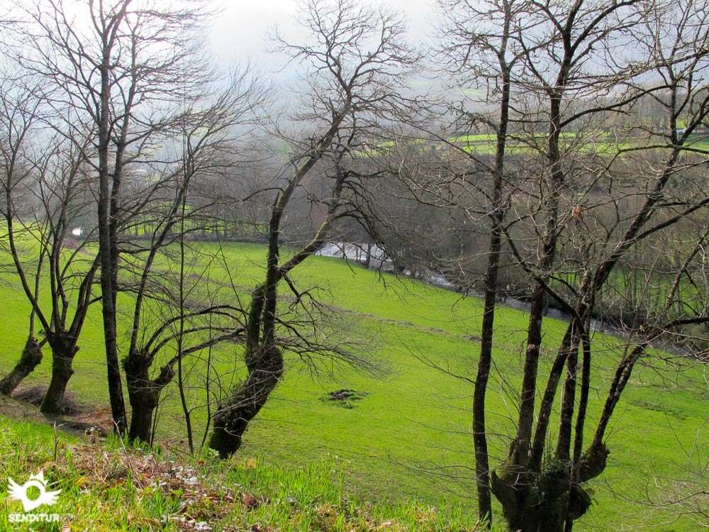
The course of the Oribio River, protagonist at all times of this stage from Triacastela to Sarria in the valley that gives it its name, is what sets the course for this route where green landscapes and lush forests are mixed with the deep-rooted cultural history that awaits us in Samos. A route that meanders between the still high mountains in search of the hidden steps that allow us to move away little by little from them. The exuberant nature that surrounds us at all times contrasts with the architectural silhouette of the Abbey of Samos that keeps great cultural treasures.

The stage 24b Triacastela-Sarria by Samos of the French Way with 24,6 Km poses us in Triacastela the first question to solve, making us decide between the two slopes that depart from there. The route compensates the unpleasant company of the road with the spectacular landscape that runs, surrounded by high mountains that try to prevent the escape of the river Oribio from their domains. The river will take us through the beautiful Desfiladero de Peña Partida, a gorge through which it flows in search of its conversion into the river Sarria. The riverside forest alternates with the pastures that give way to spectacular oaks, chestnut trees or poplars. To all this magnificent mixture of sensations we must add the not few villages through which we will pass and that will make us enter the most authentic Galicia. Villages such as San Cristovo do Real, which keeps hidden corners worthy of visiting a few steps away from the Camino de Santiago.

The rolling mountains and their extensive slopes will still put us to the test in a constant up and down that has some ramp of sufficient magnitude to take it with the necessary calm. The river, now the Sarria, plays with us, forcing us to cross it repeatedly throughout the stage, making us descend to it and then return to recover the lost height and travel halfway up the slope between corrdoiras, tracks and narrow local roads that link the villages and people of the place. Renche and Lastres rise side by side separated by the tireless river that feeds the fields, the mills and the old blacksmiths of which even today we can contemplate part of its studied structure. Freituxe and San Martiño do Real seem to follow the same curious pattern placed one on each side of the riverbank, thus distributing the fertile pastures on both sides. The entrance to Samos gives us a wonderful panoramic view of the Monastery of San Julián and Santa Basilisa, whose origins date back to the 6th century, although the current architectural ensemble dates almost entirely from the 16th to the 18th centuries.

Once we have enjoyed all that Samos has to offer, it is time to get back into the Galicia of the villages, the green meadows and the leafy corredoiras. Foxos and Teiguín lean out to the French Way separated nowadays from him by the inclement road. The high mountain of the French Way has been giving way to rounded hills that lodge localities like Pascais or Gorolfe, separated by the chapel of Santalla. The succession of meadows and forests transport us, leaving aside the town of Reiriz, until Sivil and Perros where the small chapel of Nuestra Señora do Camiño is located. Already in Aguiada both Paths are unified to travel together the distance that still separates us from the end of the stage, not before crossing San Mamede do Camiño and the small village of Vigo today fully integrated into the city of Sarria. A city that has the honour of being the starting point for pilgrims who travel the last 100 km of the Way of St. James in search of its Compostelana and to be the second city in size of those that this French Way crosses through Galicia.
Legend has it that in the place known as Pena Partida the Virgin in her long pilgrimage to Santiago de Compostela saw her passage cut by a large rock, then ordered the angels who accompanied her to open a passage for her to continue her way and these with a ray forged the Gorge of Pena Partida where the Way of Saint James passes today.
A demanding route, not only because of the continuous unevenness that they have to go up and down, but also because of the asphalt sections that undoubtedly do not contribute to reducing the accumulated wear. Luckily, shade is almost a constant and will be a good alidade on hot days. Special attention must be paid to the well known stretches of road which, even though there are sometimes small paths next to them, are still an important danger.
The provisions, water and food, can not be missing in a stage that even passing through a large number of villages will not make it easy to replace them, so we should not trust ourselves and let pass for example the fountains we find. The river, quite plentiful and even with force, is not a good option in most of the times that we approach it.
As already it comes being habitual the loose dogs and the cattle can play us some bad trick for what to our passage by the localities and its proximities we will have to extreme the precautions to avoid unnecessary disgustos.
 |
 |
 |
 |
 |
 |
 |
 |
 |
 |
 |
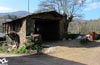
| Triacastela |  |
|
|
|
|
|
|
| ||
| San Cristovo do Real | | |||||||||
| Renche | | |||||||||
| Lastres | ||||||||||
| Freituxe | ||||||||||
| San Martiño do Real | ||||||||||
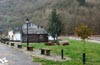
| Samos | |
|
|
|
|
|
|
|||
| Foxos | ||||||||||
| Teiguín | |
|||||||||
| Pascais | |
|||||||||
| Gorolfe | ||||||||||
| Sivil | ||||||||||
| Perros | ||||||||||
| Aguiada | |
|||||||||
| San Mamede do Camiño | |
|||||||||
| Vigo | |
|
|
|
||||||
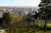
| Sarria | |
|
|
|
|
|
|
|
|
|
Variant: Stage 24 Triacastela-Sarria by San Xil
The day begins next to the square of the church of Santiago de Triacastela (0h 00min), we cross the Pilgrim Street that takes us along the town in a gentle descent.

Leaving behind us a few streets that leave our path we arrive at the end of ours, place where the French Way forks giving us the possibility of facing to our right the route that arrives at Sarria passing by San Xil or to continue with the descent by the left whose itinerary will take us until Sarria through Samos.

The latter being the chosen route, we then continue along the street on the left, which crosses a small square, descending towards the Monument to the Pilgrim that we see next to a solitary pine tree.

When we reach its height, we can already see on the right the road towards which we have to go. This road was a tiresome companion in the previous stage and will be partly so today, as it links Sarria with O Cebreiro.

Now a long stretch awaits us, following the winding line drawn by the road, a reflection of the Oribio river flowing through the surrounding mountains.

The route alternates moments in which we are forced to travel along the narrow shoulder of the road, with others in which we can avoid asphalt thanks to footpaths that have been formed with the continuous passage of pilgrims.

The guardrail also alternates location, giving us some protection or marking the maximum distance at which we can separate from the vehicles.

Ignoring the few crossroads we come across, usually sections of an old road that soon come together again, we go forward among the imposing mountains embedded on one side by the road and on the other the course of the river largely hidden by the thick vegetation that surrounds it.

In the sections of footpath we must be attentive since not all are as good alternative as one would expect, since they require us to make some balance to leave them.

We also find pieces of the old guardrail that emerge from the ground enough to make us stumble.

A long time after walking along this stretch, at the beginning of one of the curves that describe the road, the Way uses one of its old pieces to avoid us part of the journey. This small detour takes us to cross the river to leave it on our right.

Almost at the moment we return to look for the company of the road to take up again our advance. In this occasion we have a narrow footpath by which we can continue.

After a short ascent the trail is cut by the intersection with the road that gives access to several villages in the area, we still have to continue a few meters without deviating, this time on the asphalt of the verge.

In front of us we can already observe the sign that marks the detour that takes us until the first locality of the day. We have to pay attention and look for the best place to cross the road as the detour is at the exit of a curve with hardly any visibility.

We quickly began a remarkable descent that brings us closer to the first houses of San Cristovo do Real (0h 50min), to which we arrived following straight by the street that brought us here.

Just at the end of the street, to our right we find the bridge that serves us to cross again over the river Oribio.

As soon as we cross, two streets appear in front of us, separated by a kind of roundabout. The route follows the street on the left, taking us without further detours to the outskirts of the town.

The narrow street on which we continue reaches the limits of the buildings, a time when we are once again presented with two new possibilities, with the path on the left being the option to follow.

This part of the route runs between the boundaries of the pasture fields and the vertical wall of the slope that separates us from the forest.

The ascent gradually becomes more evident and makes us leave behind some path that descends towards the pastures.

Surrounded already almost in its totality by the leafy forest we continue with the ascent leaving to our left a path that invites us to abandon the forced ascent.

Protected from the sun by the shade provided by the forest we are visiting, we leave behind us the few detours that, if we followed them, would take us to nearby meadows.

The slope loses its inclination allowing us to recover from the effort required, after a while a track joins us on our right, to start together with the descent that brings us back to the banks of the river.

The forest is giving way to meadows, at the same time the path we are going out of its protection leading us without detours to the encounter of the river.

Again after crossing it we have to face a hard ascent, this time following the layout that marks us the asphalt, which makes us go higher leaving our back the green valley. These marked slides are the usual silhouette that awaits us during most of the stage.

We continue with the ascent leaving to our right the first houses of the locality through which we are about to pass.

The road, which we had abandoned miles ago, marks our entry into Renche (1h 25min).
As soon as you reach the road, turn right and continue for a few metres.

We quickly reach the detour where we return to say goodbye to the road, to undertake a strong descent that returns us to the domains of the mighty river.

At the end of the steep descent, the route turns right to follow the asphalted track that crosses the river again. We can already contemplate the first buildings of Lastres and the ramp that takes us to them.

Without leaving asphalt we find an abrupt turn of this one that allows him to continue with the ascent. We avoid this part by following the narrow street that introduces us to Lastres (1h 35min).

We crossed the locality without deviating, leaving to both sides the different accesses with which we crossed. Almost without realizing it, we see ourselves again going through a leafy forest that stretches along the riverbed.

This part of the route alternates the uncomfortable ascents with the corresponding descents, also giving us some breathing space to enjoy the environment that surrounds us.

Without practically warning us, the forest gives way to a clearer stretch where we can already sense the next locality of the day.

The track we are going along takes us to the foot of the local chapel, where we have to follow the option that takes us to a narrow road that climbs up to the chapel and passes next to it.

We begin then the descent by this road that leads us directly towards the nearby Freituxe (1h 55min).
The transit of the French Way by this locality takes us between its houses following the course that marks the road.

After a sharp bend we find, on the right hand side, the beginning of the track we must follow. We then start a new slide that will lead us from the forest to the valley. The track gains height at each step, with the added disadvantage of the thinness that the forest has in this part of the journey.

We leave on our left a path that invites us to abandon the ascent that still awaits us. Soon we reach the highest part of this stretch, from where we can contemplate the steep, cobbled descent that will take us back to the bottom of the valley.

After the cumbersome descent that requires extra effort, we come across the tireless river again, which we cross again.

On our right we can already see the church of San Martiño do Real (2h 15min), which we arrive after the path turns sharply to walk towards it.

As soon as we pass by it, we leave on the right the houses that accompany it in order to undertake or rather to continue with the pronounced ascent that we had begun next to the river.

Now it is the asphalt that guides our steps and makes us discard the different entrances that lead to the real urban nucleus of San Martiño do Real.

The tiring ascent takes us through the tunnel, which avoids the passage through the road, from where we only have a few meters left to finish the ascent.

The route leaves just at a crossroads where we will have to turn a few steps to the left to look for the continuation of the Way.

At the moment we find a road that we have to cross to start the long descent that will take us to Samos.

This part of the route, sometimes somewhat decomposed, offers us the opportunity to contemplate a beautiful panoramic view of the Abbey of Samos, before entering the narrow trench that brings us closer to the first houses in the locality.

The descent continues following the wide track into which the path has become and whose cobbled central row makes us the improvised signposting that leads us to the interior of the town.

The descent ends once again next to the river, which we must cross to finally enter Samos (2h 45min).
As soon as we cross the river, our route turns left to follow the line that marks the road again.

Following the road without more possibility we leave the locality leaving to our back all those crosses with which we are.

The Pilgrim's Square bid us farewell to Samos as we head towards the outskirts of the town. Soon we see ourselves again progressing along the path that borders the road, following the course marked by the river.

Foxos (3h 00min), formerly an obligatory pass, appears on the slope of the mountain, leaving us a small rest area as a silent witness of its link with the Way of Saint James.

The route continues its untiring course that takes us to Teiguín (3h 10min), a town that, like the previous one, is on the opposite side of the road.

The passage of the itinerary through this place follows a short detour, if we wish, that avoids us part of the road taking us by a cozy rest area next to the river, to return next to the road.
Once again on the path at the edge of the road, we leave this small town behind us to continue in search of the nearby detour that awaits us.

On the other side of the road begins an asphalted track along which the French Way continues. It is at this point where, for strange reasons, many pilgrims decide to continue straight ahead following the layout of the road. This recommended route for cyclists, to our understanding that they use a road bike, saves us a few 3 km, as long as we follow the road to the letter.

If you follow the road, the wide path that continues from the detour is diluted until it disappears, sometimes forcing you to take detours due to the lack of space for vehicles and pedestrians. In addition we will not cross any urban zone until Sarria, reason why if we need to replace provisions also we will have to add kilometers to the total, to approach the near populations by which we will pass. If we add to all this the danger of a road with a lot of traffic, it means that the saving in kilometres does not compensate for the irrigation that we will undoubtedly take if we follow this route on foot.

Following the marked path, a steep climb up the asphalt track awaits us, reminding us of moments gone by.

The asphalt leads us without error to the limits of Pascais (3h 35min), where just at the entrance we find the detour we have to follow.

The asphalt gives way to a narrow road, in not very good condition, which makes us recover our orientation with the valley to our left, partly avoiding the strong ramps that brought us here.

The route continues its course embedded between the walls that separate the fields that surround us, leaving on both sides the entrances that lead to them.

In a short time, the path becomes wider and wider, while the forest allows us to contemplate what surrounds us, to reach once again the meeting of a road that joins us on our right. Next to it we begin a gentle descent towards the buildings in front of us.

When reaching its height, it leaves the asphalt again, and we turn off following a dirt track that starts on our left. The track, which passes by the wall of the church, makes us lose the height gained by entering the dense forest again.

The track loses its good firm forcing us to descend calmly, shortly after entering the forest the route makes a sharp turn to the right leaving the track by which we advance that continues its straight course.

This stretch meanders through the interior of the forest looking for the best place to save the valley that forms a small stream that runs down the valley. The route runs halfway up the slope, making us save the gentle undulations that it has, following the nearby course of the river that flows to our left.

The path we are following, well marked, maintains the same layout as previous sections, leaving behind the different paths they meet, gradually approaching the next locality of the stage.

We arrive at Gorolfe (4h 00min) after a quick descent that takes us to its church, where we find the road. The Way of St. James then turns right following the course that now marks the asphalt again.

Luckily, shortly after leaving the locality we find a small shortcut that allows us to avoid the long curve that the road draws.

The footpath, with almost no time to enjoy it, takes us back to the asphalt that we have not been rid of for quite a few kilometres. The route along this road allows us to contemplate the town of Reiriz, located at the top of a small hill in front of us.

The route does not leave the road at the junctions with which it meets, allowing us to advance with relative comfort. Shortly after crossing over the river, on our left, we leave the road that leads to Reiriz to continue straight ahead, leaving this locality behind us.

We continue with the comfortable route following the course of the river without deviating from the road that serves as a reference at the crossroads we pass.

Our way joins again with another road that arrives from the town of Reiriz that before we left behind us, to continue together straight towards a farm that we already see to the front. When you reach its enclosure, the road turns right to go towards the inseparable river.

After crossing the river our itinerary progresses escorted by a multitudinous chopera that hides us the green Galician landscape.

After a short time the road begins to take a slope, at which point we must leave it and continue along the track that begins on its left, thus avoiding part of the slope that already began to have.

The track leads us without a doubt to the first house in the next locality, where we arrive following the asphalted track that introduces us into the small town of Sivil (4h 40min).

The asphalted track, forced by the houses of Sivil, turns to the left, taking us quickly out of the town. Again a continuous up and down transports us through the fields that surround us.

The asphalt track makes us leave behind the different paths we encounter, taking us without problems towards our next objective.

The locality of Perros (5h 00min) receives us giving us not few options to enter it. The French Way continues without detours leaving to both sides how many streets or ways we can find.

Without further distraction we soon find ourselves on the outskirts of Perros undertaking a short climb up a decomposed track.

The road to Sarria passes over our heads just before the entrance of the French Way in Aguiada (5h 10min).

The route goes straight on, passing through the narrow space that the houses leave you, to go out to the main street where we will be joined by the pilgrims who took the road that passes through San Xil.
Once both Ways have been unified, we continue wandering around the town following the long street that crosses it from side to side.

With no more detours than those that the street itself draws, we arrive at the outskirts of Aguiada to follow the stretch of asphalt that takes us to the meeting of the road that reaches Sarria.

Luckily when arriving at its height we found the beginning of the andadero that allows us to avoid the transit by her, we have that yes, that to advance a few meters to find it. A long stretch awaits us, always with the uncomfortable company of the road, leaving on both sides as many crosses leave our path.

At one of these crossroads is San Mamede do Camiño (3h 40min) a short distance from Aguiada and still far from Sarria. This part of the route, less demanding in unevenness, continues to maintain the undulating course that has accompanied us for a large part of the stage.

There are many crossroads and roads that, always following the course marked by the nearby road, we must leave behind us..

Sarria is already intuited in front of us, but we still have a heavy stretch, already sheltered by the first buildings that indicate the proximity to the city.

After crossing a small rest area, the Way enters definitively among the large buildings that have engulfed the village of Vigo (4h 10min).

The road, which has already become a street in the city, is still our reference to follow, without having to detour in any of the streets we are currently in.

A building divides in two the street making us choose between the two options, being the street of the right the one that we have to follow.

This street goes out immediately to a wide avenue that cuts it, in front of us we see the street where the Way continues. Once crossed this avenue the new street by which we pass arrives, shortly after leaving to its left another street, to a roundabout.

Here, if we are following the sidewalk on the left, we have to turn off a few metres in search of the pedestrian crossing that will allow us to cross to continue straight on the wide avenue that begins at this point. While if we are following the sidewalk on the right, which on the other hand is the one that from now on is more advisable for us to follow, we only have to continue the flow that this sidewalk draws for us.

The wide Pilgrim's Rua meanders between the buildings leading us undoubtedly into the interior of the city.

This street takes us to the bridge over the river Sarria which we cross to reach straight on to the end of the Pilgrim Street in Sarria (4h 25min), where this stage ends.
 Distance. 24,6Km
There are pilgrims who largely follow the route of the road, which affects the distance of the stage.
 Time. 6:10min
The accumulated fatigue or the deceptive perception of a simple stage in terms of the slope can play a bad trick on us making it take a little longer than the indicated. On the other hand, the almost obligatory stop at Samos also adds minutes to the total time even thoug:these are fully justified. In case of following the road all the time, the difference in mileage does not make us notice as muc:difference as we could have imagined.
 Time of year
The route is simply spectacular, althoug:the fog and the famous bad weather of Galicia can make the day bitter. We will not have the great panoramic views of other stages, but we will be able to enjoy the special corners that are hidden along the way and the spectacle formed by the forests or the gorge that we will cross. Without a doubt, autumn and spring bring their special colours to a landscape that is beautiful to walk through.
 Material required
This is a stage that can initially be done wit:a more comfortable footwear, suc:as hiking shoes. But not infrequently we will ask for a stronger shoe that protects and nods the foot, so if we are the ones who free the foot of ties to the slightest possibility is not too muc:to keep the boots at hand. For the rest apart from adapting our clothes and footwear as it is logical to the conditions of the weather, we would not have to lack something of clothes that protects us of the rain and of the wind that to the first hours of the morning and even in summer will do that the day is fresh. The protection against the sun and the sunglasses next to the cap must not forget us thinking erroneously that we are not going to miss them given the shade that in great average we will enjoy. Of course the camera of photos can not miss us and not this one more to carry a reflective or frontal for the sections of highway especially to first hours of the morning. It is very important, as in all stages but in this one even more if it fits, to transport the water and the sufficient food since we will not find many places where to replace the provisions. Consult our list of material and equipment to make the Way. Read more
 Difficulty. Moderate
Physical
A more demanding stage than one would expect given its continuous and demanding ramps which, althoug:not very long in distance, will force us to make an extra effort in the ascents and some expertise in some of the descents. The shadow is an ally in great part of the route but we must not fall into the error of underestimating the heat that we can get to spend the summer days, so water and some food should be our inseparable companions.
Caution
It goes without saying that the kilometers of road, even counting in many of them wit:paths next to it, are a risk to our safety. The road from Triacastela to Sarria bears a lot of traffic and in some sections we will be forced to circulate throug:a narrow shoulder that brings us closer, more than desired, to the vehicles. Attention also in the paths at the edge of the road since in some sections we will find the pointed remains of the steel beams that supported the old guard rails and that someone left sticking out of the ground as traps for the pilgrim.
Orientation
Itinerary in principle easy to follow but whic:is complicated because the marks are largely quite old, are worn or are little visible, whic:means that not a few pilgrims end up wandering the roads without knowing where they are. In addition we will find more than one, these yes, clear marks that invite us to take a detour to visit different places not so close to the Camino as at first seems. Also the thick vegetation does its own hiding signs and making what should be a well-defined and clear road seems not to be as traveled as it actually is. Beware of the detour after Teiguín, the continuity of the andadero next to the road added to the old sign indicating straight for bicycles makes many pilgrims follow the layout of the road, whic:on the other hand is the one marked on the official topographical maps.
 |
 |
 |
 |
 |
| 1-Triacastela | 0:00min | 664m | 0Km | 29T 644042 4735215 |
| 2-San Cristovo Do Real | 0:50min | 589m | 3.9Km | 29T 641371 4733440 |
| 3-Renche | 1:25min | 594m | 5.7Km | 29T 639898 4733355 |
| 4-Lastres | 1:35min | 582m | 6.1Km | 29T 639541 4733407 |
| 5-Freituxe | 1:55min | 581m | 7.3Km | 29T 638507 4733592 |
| 6-San Martiño Do Real | 2:15min | 562m | 8.5Km | 29T 637841 4733074 |
| 7-Samos | 2:45min | 529m | 10Km | 29T 636990 4732251 |
| 8-Foxos | 3:00min | 517m | 11.2Km | 29T 636228 4731818 |
| 9-Teiguín | 3:10min | 512m | 11.7Km | 29T 635781 4731518 |
| 10-Pascais | 3:35min | 576m | 13Km | 29T 635520 4732365 |
| 11-Gorolfe | 4:00min | 501m | 14.9Km | 29T 634631 4733267 |
| 12-Sivil | 4:40min | 492m | 18.2Km | 29T 634984 4735810 |
| 13-Perros | 5:00min | 475m | 19.6Km | 29T 634477 4736702 |
| 14-Aguiada | 5:10min | 496m | 20.2Km | 29T 634004 4736980 |
| 15-San Mamede do Camiño | 5:25min | 487m | 21.4Km | 29T 632818 4736997 |
| 16-Vigo | 5:55min | 420m | 23.8Km | 29T 630505 4737149 |
| 17-Sarria | 6:10min | 426m | 24.6Km | 29T 629831 4737207 |
Coordinates UTM Datum WGS84

 Slope: 1262m
 Slope +: 512m
 Slope -: 750m
 Maximum altitude: 670m
 Minimum altitude: 420m

This sketc:of the route is not made to scale nor does it contain all the information relating to the area, it is merely indicative.

![]()
This schematic wit:the pat:is approximate and has been created from the derived cartographic base © Instituto Geográfico Nacional "Cuadrante 124 1:50.000".
Senditur has manipulated the tracks to correct the aberrant points that may exist, caused by problems wit:the reception of the GPS signal. In any case the tracks are always approximate. SENDITUR encourages you to use the new technologies within your reach, using them as support and consultation in your activity, not basing the realization and orientation of the same only and exclusively on them, since they may see their functioning altered by very diverse causes, not functioning correctly and their indications may not be precise.


Una pena que tenga tanto tramo de carretera, pero aun así es una opción muy bonita e interesante que hace difícil elegir entre ir por una u otra ruta desde Triacastela.


Find out what to see in...
¿Did you know that...
The section of the route that goes from Triacastela to Samos is known as the Royal Way or the Oribio because this is the itinerary chosen by the kings to access the Abbey of Samos. This river Oribio accompanies us in the first part of the stage giving way to the river Sarria that will do the rest, although there are not few voices that unify both rivers making it only one from beginning to end.
Don't miss out...
The Abbey of Samos, as the Royal Monastery of San Julián is known, which has its origin in the Visigothic period, is attributed to its foundation to San Martín Dumiense in the 6th century and which houses incalculable works of art and architecture worthy of making a stop on the Way to get to know them.


From the commitment of SENDITUR with Nature and the respect to the balance of the environment, SENDITUR urges you to travel in a responsible way, with low environmental impact and respecting at all times the Natural, Cultural and Social environment wherever you go.

Besides sharing with all of us your experience on the route we would be grateful if you could write to us to inform us of any erroneous or outdated information you may have found, or simply to let us know what you think at Thank you.
This route has been carried out in the field by SENDITUR on 08-10-2018. The route may vary greatly depending on the time of year, weather conditions and terrain, as well as the actions of third parties and the evolution suffered in the natural environment where it is located. All opinions, advice and/or assessments made by SENDITUR in their descriptions are for guidance only and are subject to and/or refer to the specific conditions of the specific day of the route, referring to that specific day, taken from trained people, with the appropriate experience and with a high level of physical and technical preparation as a reference, as well as correctly equipped.
All the times are approximate and take an orientative character, the stops have not been taken into account, no matter how small they are. All the information related to the route, texts, images, videos, maps, diagrams, tracks, towns, and places of tourist interest are published as a guide, and may not coincide with the current state of each place. Before undertaking any activity, assess your technical knowledge, your physical condition, find out about the weather and the variations that the route may undergo, equip yourself correctly, be prudent and responsible at all times, and do not exceed your capabilities. SENDITUR is not responsible for any misuse or inappropriate use of the comprehensive guides of its routes and/or publications as well as its electronic guides, nor for any variations in their descriptions for the aforementioned reasons, and recommends that everyone be responsible and prudent in carrying out the activity. We also encourage you to read books and specialised guides to complement the information described above.
Continue watching …
 Previous: Stage 23 O Cebreiro-Triacastela
 Next: Stage 25 Sarria-Portomarín