Welcome to SENDITUR.COM · paths · routes · tourism


Stage 24 Triacastela-Sarria by San Xil
Leafy forests, green valleys
![]() Difficulty-Medium
Difficulty-Medium
![]() 4:25 h.
4:25 h.
![]() 18.1 km.
18.1 km.
Leafy forests, green valleys
![]() Difficulty-Medium
Difficulty-Medium
![]() 4:25 h.
4:25 h.
![]() 18.1 km.
18.1 km.
The valley of the Oribio river, at the foot of the protected natural space of the mountain ranges of Os Ancares and Courel, forges the hallmark of this stage that from Triacastela twists from valley to valley between the last great mountains of the French Way in search of the wide valley of the river Sarria that gives its name to the town that has the privilege of being the starting point of the last 100 km of the Jacobean route. An itinerary marked by the dense forests that house chestnut or oak trees, among others, and the magnificent panoramic views that the green valleys offer us, passing through villages whose name still survives thanks in part to the establishments that offer their services to the pilgrim.

The stage 24 Triacastela-Sarria by San Xil with 18,1 Km leaves next to the church of Santiago in Triacastela, locality where we will have to decide which itinerary of the Way of Santiago we want to follow, if the one that takes until Sarria passing by Samos and its monastery or the one that goes up the valleys taking us until Sarria by San Xil. Once the doubt is solved, the route towards San Xil takes us to ascend the valley that from Triacastela reaches the small village of A Ferrería and quickly up to A Balsa. After passing by its hermitage, the ascent begins definitively that will take us to the Fonte dos Lameiros. This section gives us a quiet but demanding run, sheltered by the lush oaks that transport us through the villages through which the French Way passes. San Xil remains to our left while we continue with the ascent that will take us to the Alto de Riocabo.

The so characteristic Galician corredoiras already are making act of presence interspersed with ample pastures that, next to them, contribute a special beauty to this route. Montán is another of the villages to which the French Way approaches, caressing it without getting fully into it. Fontearcuda marks the descent to a new valley from which we will have to go up part of the lost height to reach Furela, where its chapel of San Roque awaits us and shortly after the entrance to the Concello de Sarria. The mountains almost without realizing it have been left behind and already we only have a soft descent that will separate us definitively from them. Pintín de Arriba is the gateway to the wide valley of the river Sarria and gives way to the solitary church of Santo Estevo de Calvor, we will find it a few meters in the middle of the road where it crosses the Camino de Santiago, is an old monastery founded in the eighth century.

Calvor, a village that does not fully cross the French Way either, is the prelude to the union of the two options that were proposed to us in Triacastela, more specifically it is in Aguiada, where the two Ways become one again. From here, the route will lead us to the end of the stage, visiting villages such as San Mamede do Camiño or Carballal, before reaching the small village of Vigo, today engulfed by the expansion of the city of Sarria, which we will reach by following, as could not be otherwise, the Rúa do Peregrino. This town founded by Alfonso IX, closely linked to the Way of St. James keeps inside much of its history and culture that will undoubtedly surprise us.
The coincidence of Sarria with the last 100 kilometres of the Camino necessary to obtain the much desired Compostelana makes this city the starting point chosen by many pilgrims. This fact means that in periods of greatest influx of pilgrims and although the city has a good number of establishments, it is relatively difficult to find places available. The short distance of this stage allows the less foresighted to extend their journey to Barbadelo or Rente where we will also find alternatives as the end of the stage.
Perfect layout to recover it from previous efforts if we control it a little in the first part of the course which is the most demanding. The route alternates areas of shadow with clear areas, so the heat initially should not be a problem. A lot of attention to the road sections and to the repeated crossings, we cannot fall into the error of thinking that there will be no traffic through it.
This, as it should always be, is a stage in which we cannot miss the water and the food, since we will not pass many places where we can stock up and if we miss any of the two we will make a simple stage a hard test for our friend.
A lot of attention, to the passing by the villages, with the dogs loose and in almost all the route with the cattle that without a doubt we have to find. We are in a favourable terrain for parasites so a glance at the end of the day is not too much.
 |
 |
 |
 |
 |
 |
 |
 |
 |
 |
 |
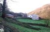
| Triacastela |  |
|
|
|
|
|
|
| ||
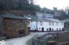
| A Ferrería | |
|||||||||
| A Balsa | |
| ||||||||
| San Xil | ||||||||||
| Montán | |
|||||||||
| Fontearcuda | |
|||||||||
| Furela | |
|||||||||
| Pintín de Arriba | |
|
||||||||
| Calvor | |
|||||||||
| Aguiada | |
|||||||||
| San Mamede do Camiño | |
|||||||||
| Vigo | |
|
|
|
||||||
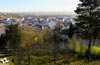
| Sarria | |
|
|
|
|
|
|
|
|
|
Variant: Stage 24b Triacastela-Sarria by Samos
We begin the stage following the elongated Pilgrim's Rúa that from the square of the church of Santiago leads us through Triacastela (0h 00min).

Following the straight line that marks the street, we leave behind the different crossroads we come across.

The gentle descent that marks our route following this long street takes us to the end of it, just where the French Way is divided in two, forcing us to decide between the route on our left, which reaches Sarria before passing through Samos or the itinerary on the right that does passing through San Xil.

We turn right to follow the San Xil road, which leads us directly to the nearby road.

On reaching it, a few metres to the right we see, on the other side, the beginning of the road leading to San Xil. We are forced to go back along the road, as if the Way of Saint James wanted to return towards Triacastela, to cross to the other side and leave this locality behind us definitively.

The itinerary follows the course marked by this road, which looks more like an asphalted track, crossing the green pastures that normally characterise the Galician stages.

Soon the road takes us through a factory, where we leave behind us the paths that depart from it, to follow the course indicated by the asphalt.

Shortly after passing this one, in hours of work, uncomfortable section, we leave to our right a new path that initiates a more marked ascent than the one that we begin to take.

A few minutes later we find ourselves at a bifurcation, where the road makes us choose between starting a demanding ascent or following the option on the right, which follows the French Way, which for now does not require much effort and even makes us descend initially. The asphalt disappears quickly replaced by the whitish cement broken by a paved row that marks the axis of the track that we travel.

The route follows the undulating course that draws the track down to the nearby creek whose rumor we already heard some time ago.

Shortly after crossing the creek, the straight row of cobblestones leaves the cement track to take us to the beginning of a dirt road where we must continue.

This way avoids us to continue with the uncomfortable ascent that before we had initiated, between the trees that we have in front of us already let intuit the first houses of the following locality by which we passed.

The path reaches them, joining a track on our right that will surely be the one we had abandoned before, and together we will enter the small village of A Ferrería (0 30min).

The route quickly crosses this town without paying attention to the few crosses on both sides, to leave the protection of the houses away from them.

With almost no time to get used to the idea of returning to the relative solitude of the Way, the next locality that crosses the itinerary meets us.

The route returns to follow without detours the course marked by the houses that make up A Balsa (0h 35min) that extends around him.
The cobblestone street leads us to cross the creek again, which, almost without realizing it, had accompanied us all this time.

As soon as you cross it, the route turns to the right and a gentle ascent begins along a narrow street that takes you out of the locality for good.

Shortly after leaving behind us the last houses and the hermitage of A Balsa, the itinerary leaves the cement track, which turns radically to the left, to continue along the hidden path that starts right at this point.

The path to follow is embedded between the slope of land that marks the boundaries of the forest and access to an agricultural area. The ascent, which we had already begun without realizing some time ago, is now much more evident forcing us to make a greater effort than desired.

The path, usually very muddy, runs bounded on both sides by sometimes high walls that remind us of the unmistakable trenches of the railway.

We continue with the ascent protected from the untiring sun by the shade provided by the lush forest we are walking through, we are leaving behind the different accesses to the fields of pastures that we are.

In few occasions the trench that accompanies us gives us a small respite diminishing its height or letting us enjoy the forest for which we go.

The slope seems to soften in part at the same time as the road improves, indicating the proximity of the end of this stretch that comes to meet the road that we followed at the beginning of the day.

The route then continues its ascent towards a small rest area embedded in the slope of the mountain.

The road leads us directly to a new crossroads where the Way of Saint James turns left, continuing with the ascent and following the asphalt course.

To our left we can already see the first houses of San Xil, a town that we pass almost without entering, since a large part of its urban nucleus is separated from the road along which the French Way passes.

Soon we arrive at the first crosses on our left that lead us to San Xil (1h 00min) although we have to ignore them and follow without detours the direction that the road shows us.
The shadow that protected us from the implacable sun has long since disappeared, leaving us at its mercy but also allowing us to contemplate the landscape that surrounds us.

Little by little San Xil is being left behind, the road continues being our inseparable companion, since for now we do not have to abandon it at any moment. The steep slope we had to face before reaching San Xil has given us a little respite, softening its demands.

After a while you follow the road and go up another steep slope you will come to the detour where you have to leave the asphalt.

There is a dirt track on our right that serves as a guide along this stretch of the route. This dirt track, after a short ascent, allows us to recover energy by starting a gentle descent that introduces us back into a lush forest leaving behind us some path that comes out on our way.

The whimsical track, which ascends as soon as it descends, leads us almost without shaded areas through the pastures, leaving to the left and right as many paths as we can find.

The track takes us to a bifurcation where the Way of St. James deviates following the option on the left of the two that present themselves to us, starting a new descent shortly afterwards.

The route continues between the slopes that border it, taking us to a new fork where the track we are going along turns sharply to the left, inviting us to follow it given its good condition, but the French Way continues the straight descent embedded in the narrow trench that delimits it.

This section, which is not in very good condition, continues to take us to the next locality, which we can already see on our left and which, as on the previous occasion, we almost slipped past.

We continue with the descent along the path marked by the walls that surround us, leaving on our left what seems to be the access to the nearby town. Almost without noticing the stone walls that enveloped us have given way to the buildings that mark our entrance in Montán (1h 55min).

As soon as you enter the town, the route turns right, taking you directly out of Montán. The locality is behind us and we see ourselves again crossing the green fields that surround us.

The track we're on, as could not be otherwise, is leaving on both sides the paths leading to the different fields.

After a while our track is joined on the right by a wide path to continue together towards the next town of the day. The wide track of good firm continues its course taking us without detours between impressive trees.

We quickly reach the small village of Fontearcuda (2h 10min) where we continue straight ahead leaving to the left and right the crosses with which we find ourselves.

Again we find ourselves following the dirt track surrounded by large trees and fields of pastures.

Without warning and after a cobbled descent the road cuts our way forcing us to follow it for a few meters.

When you get to the road, continue on the right, descending in search of the continuation of the path it cut.

When we find the beginning of the path we will turn radically abandoning the road to continue the descent by the path that crosses the leafy forest that surrounds us.

Just after reaching the limits of the forest, the French Way changes its orientation again, leaving a track on the left, to continue with the comfortable descent.

The wide path meets a small stream that crosses it, at this point we find a stone footbridge that prevents us from getting stuck when fording the stream.

The track follows the pattern brought here advancing between the fields and leaving behind the paths that serve as access. Unfortunately, the dirt track ends when it meets the road we left behind.

Now we have to follow the cumbersome asphalt of this road which, without hard shoulder, accompanies us almost at all times until the end of the stage. At the edge of the asphalt we have a meagre path that separates us in part from the road.

Shortly after going out to it we arrive at a new crossing where the Way of Saint James gives us the option to leave for a few meters the layout of the road to make a small detour. This section descends a few metres to turn right and climb the lost height again.

Quickly we see ourselves again at the edge of the road we had left at the previous crossroads. The asphalt acts as a guide leading us to the next detour, fortunately this section has a kind of path that helps us to avoid the road.

Soon we arrive at the next crossroads where to our left begins the paved street that introduces us in Furela (2h 40min), to which we arrive following it without leaving it in any moment.
This street leads us on our way through the town, leading us to pass by the hermitage of Furela.

Shortly after this hermitage, almost at the same time that the cobbled street ends, the path where we must follow begins on our right.

At the moment we begin a soft ascent and we find ourselves with a new detour where we return to follow the path of our right that borders the wall that delimits the last buildings of the locality.

Once again the road gets in the way of our route, forcing us to cross it to continue along the path that now runs to the other side. This section, without any loss, takes us to the next town we pass through.

The path gradually separates from the road, to turn again when it meets the stone wall that delimits the first houses of Pintín de Arriba (2h 55min), to which we arrive following its course.
At our entrance to the town, the itinerary turns right to follow the cobbled street that leads us through Pintín.

Following the limits marked by the houses and leaving behind the few detour options we find, we arrive at the outskirts of the town.

Once again it is the asphalt that leads us to the next detour that we must face.

A few metres before reaching the height of the road that has harassed us for many kilometres, we find ourselves at the beginning of the path we must follow.

This dirt track takes us without detours until we cross the well-known road again, as the French Way goes straight on, shortening part of the route it draws. Once we cross to the other side a vertiginous descent awaits us that concludes in the accesses to what seems to be a gravel pit.

After a few metres following the track that runs parallel to the nearby road, you have the chance to escape from it and follow a narrow path fitted between the two or continue along the track until both possibilities come together again shortly afterwards, just at Calvor (3h 15min).

Now a section awaits us following the route of the road without having to step on the asphalt, thanks to the path that starts here.

After a relatively short stretch of road and shortly after crossing a track on your left, it is time to cross the road again.

On the other side begins the access section that takes us undoubtedly to the interior of Aguiada (3h 25min), where we will be joined by the pilgrims who, in Triacastela, would have decided to follow the route that passes through Samos.
Once both Ways have been unified, we continue wandering around the town following the long street that crosses it from side to side.

With no more detours than those that the street itself draws, we arrive at the outskirts of Aguiada to follow the stretch of asphalt that takes us to the meeting of the road that reaches Sarria.

Luckily when arriving at its height we found the beginning of the andadero that allows us to avoid the transit by her, we have that yes, that to advance a few meters to find it. A long stretch awaits us, always with the uncomfortable company of the road, leaving on both sides as many crosses as we can see.

At one of these crossroads is San Mamede do Camiño (3h 40min) a short distance from Aguiada and still far from Sarria. This part of the route, less demanding in unevenness, continues to maintain the undulating course that has accompanied us for a large part of the stage.

There are many crossroads and roads that, always following the course marked by the nearby road, we must leave behind us..

Sarria is already intuited in front of us, but we still have a heavy stretch, already sheltered by the first buildings that indicate the proximity to the city.

After crossing a small rest area, the Way enters definitively among the large buildings that have engulfed the village of Vigo (4h 10min).

The road, which has already become a street in the city, is still our reference to follow, without having to detour in any of the streets we are currently in.

A building divides in two the street making us choose between the two options, being the street of the right the one that we have to follow.

This street goes out immediately to a wide avenue that cuts it, in front of us we see the street where the Way continues. Once crossed this avenue the new street by which we pass arrives, shortly after leaving to its left another street, to a roundabout.

Here, if we are following the sidewalk on the left, we have to turn off a few metres in search of the pedestrian crossing that will allow us to cross to continue straight on the wide avenue that begins at this point. While if we are following the sidewalk on the right, which on the other hand is the one that from now on is more advisable for us to follow, we only have to continue the flow that this sidewalk draws for us.

The wide Pilgrim's Rua meanders between the buildings leading us undoubtedly into the interior of the city.

This street takes us to the bridge over the river Sarria which we cross to reach straight on to the end of the Pilgrim Street in Sarria (4h 25min), where this stage ends.
 Distance. 18.1Km
The route through Sarria will determine the real distance of the stage.
 Time. 4:25h
Short stage in distance that even considering the sections of ascent, we will be able to cross wit:relative rapidity. In the case of being forced to follow the layout of the road, this time will be considerably extended since there are not a few kilometres to be added to the total of the stage.
 Time of year
The route offers spectacular panoramic views throughout the year, althoug:it is true that at certain times of winter we must surely find ice and snow that hinder progress while bringing a special touc:to the landscape. Rainfall and fog are common almost all year round, whic:means that some stretches of the route are very muddy. In summer the shade that protects most of the itinerary is interspersed wit:completely clear areas that will punis:us for sure.
 Material required
Althoug:the end of the stage is by andadero and part of it also by asphalt, the boots for the rest of the route are indispensable. The special climate of Galicia can not catc:us unnoticed so in the backpack we can not miss rainwear and warm clothes. For the rest to the material according to the climatic conditions and of the time of the year we must add water and food more necessary than in other stages when we do not find too many services in all the route. The camera cannot be forgotten, as well as the sunglasses, the cap and the sun protection cream. Consult our list of material and equipment to make the Way. Read more
 Difficulty. Medium
Physical
Althoug:the distance is by no means a problem for the pilgrim who has come here we do not have to underestimate the route, as it is quite a leg-breaker wit:some strong climb and a rolling descent that will not make things as easy as they seem. For the rest it is a stage to enjoy and recover lost forces.
Caution
We are going to find the biggest problems in the road sections, wit:more traffic than we could imagine and in the always dangerous junctions. Attention on foggy or snowy days, althoug:the route to follow is quite clear the large number of crossings and signs can play a bad game us. A lot of attention also wit:the mud and the stone chips that we will find in some descents, make the skids are more common than normal and more than one pilgrim have cost a good fall.
Orientation
The signposting of the two routes is very clear, we only have to choose one or another option. Once on the way we find quite a few crossroads where the marks of the Way generally help us to follow it, althoug:the proximity of the different villages will make us find more than one mark that will take us to them even if the Way does not pass or close. It is also likely to find the marks worn or almost erased, making it more difficult than usual to follow the route. All this forces us to be more attentive than normal to avoid the inconvenience and miles of more than one error of course.
 |
 |
 |
 |
 |
| 1-Triacastela | 0:00h | 664m | 0Km | 29T 644038 4735216 |
| 2-A Ferrería | 0:30h | 709m | 1.9Km | 29T 642876 4736310 |
| 3-A Balsa | 0:35h | 718m | 2.3Km | 29T 642698 4736564 |
| 4-San Xil | 1:00h | 860m | 3.8Km | 29T 641423 4736420 |
| 5-Montán | 1:55h | 762m | 7.6Km | 29T 638851 4736365 |
| 6-Fontearcuda | 2:10h | 738m | 8.3Km | 29T 638315 4736516 |
| 7-Furela | 2:40h | 664m | 10.6Km | 29T 636885 4737042 |
| 8-Pintín de Arriba | 2:55h | 630m | 11.7Km | 29T 635863 4737036 |
| 9-Calvor | 3:15h | 524m | 13.1Km | 29T 634567 4737003 |
| 10-Aguiada | 3:25h | 496m | 13.7Km | 29T 634004 4736980 |
| 11-San Mamede do Camiño | 3:40h | 487m | 14.9Km | 29T 632818 4736999 |
| 12-Vigo | 4:10h | 420m | 17.3Km | 29T 630505 4737150 |
| 13-Sarria | 4:25h | 426m | 18.1Km | 29T 629836 4737207 |
Coordinates UTM Datum WGS84

 Slope: 982m
 Slope +: 371m
 Slope -: 611m
 Maximum altitude: 875m
 Minimum altitude: 420m

This sketc:of the route is not made to scale nor does it contain all the information relating to the area, it is merely indicative.

![]()
This schematic wit:the pat:is approximate and has been created from the derived cartographic base © Instituto Geográfico Nacional "Cuadrante 124 1:50.000".
Senditur has manipulated the tracks to correct the aberrant points that may exist, caused by problems wit:the reception of the GPS signal. In any case the tracks are always approximate. SENDITUR encourages you to use the new technologies within your reach, using them as support and consultation in your activity, not basing the realization and orientation of the same only and exclusively on them, since they may see their functioning altered by very diverse causes, not functioning correctly and their indications may not be precise.


Find out what to see in...
¿Did you know that...
A Corredoira is a narrow rural path embedded between walls and fields that communicates the villages, also providing service for rural work, crossing mountains and valleys under the shade of trees that provide its shade as if it were a protective roof.
Don't miss out...
In Sarria, the convent of La Madalena, which grew around the hospital built there in the 13th century, brings together different architectural styles such as its plateresque façade, the Gothic church or the 16th century cloister, and the rooms that are neoclassical in style.


From the commitment of SENDITUR with Nature and the respect to the balance of the environment, SENDITUR urges you to travel in a responsible way, with low environmental impact and respecting at all times the Natural, Cultural and Social environment wherever you go.

Besides sharing with all of us your experience on the route we would be grateful if you could write to us to inform us of any erroneous or outdated information you may have found, or simply to let us know what you think at Thank you.
This route has been carried out in the field by SENDITUR on 07-10-2018. The route may vary greatly depending on the time of year, weather conditions and terrain, as well as the actions of third parties and the evolution suffered in the natural environment where it is located. All opinions, advice and/or assessments made by SENDITUR in their descriptions are for guidance only and are subject to and/or refer to the specific conditions of the specific day of the route, referring to that specific day, taken from trained people, with the appropriate experience and with a high level of physical and technical preparation as a reference, as well as correctly equipped.
All the times are approximate and take an orientative character, the stops have not been taken into account, no matter how small they are. All the information related to the route, texts, images, videos, maps, diagrams, tracks, towns, and places of tourist interest are published as a guide, and may not coincide with the current state of each place. Before undertaking any activity, assess your technical knowledge, your physical condition, find out about the weather and the variations that the route may undergo, equip yourself correctly, be prudent and responsible at all times, and do not exceed your capabilities. SENDITUR is not responsible for any misuse or inappropriate use of the comprehensive guides of its routes and/or publications as well as its electronic guides, nor for any variations in their descriptions for the aforementioned reasons, and recommends that everyone be responsible and prudent in carrying out the activity. We also encourage you to read books and specialised guides to complement the information described above.
Continue watching …
 Previous: Stage 23 O Cebreiro-Triacastela
 Next: Stage 25 Sarria-Portomarín