Welcome to SENDITUR.COM · paths · routes · tourism


![]() Difficulty-Medium
Difficulty-Medium
![]() 5:45 h.
5:45 h.
![]() 22.3 km.
22.3 km.
![]() Difficulty-Medium
Difficulty-Medium
![]() 5:45 h.
5:45 h.
![]() 22.3 km.
22.3 km.
Sarria is the point chosen by many pilgrims as the start of their pilgrimage to Santiago de Compostela, a route through green meadows, fertile orchards and thick forests of oaks and chestnut trees with formidable trunks that will take us to the deep bed of the river Miño, whose flow is stopped downstream by the dam of the Belesar reservoir. A route that will allow us to enter the Galicia of the villages, the old forts and the culture, together with the traditions, that here left Celts and Romans, the old inhabitants of these lands.

The stage 25 Sarria-Portomarín of the French Way with 22,3 km leaves from Sarria making us cross part of its historical helmet that transports us to the deep history that this city has. An example of this is the church of Santa Mariña from the 19th century in the middle of Rúa Maior, where 18th century palaces and the Gothic temple of Salvador from the 13th century meet. At the top of the hill, dominating the population, is located an impregnable fortress of which today as the most visible rest resists its imposing tower, without forgetting the Convent of the Magdalena where different architectural styles are mixed and where we will say goodbye to Sarria. The route is full of small corners that still keep part of the testimony lived years ago, as the Ponte da Áspera of the XIII century that even today gives service to the pilgrim allowing him to cross the Small river, or the Castro de Paredes that protected by the thickness of the trees shows us the foundations of the characteristic pre-Roman settlements.

Vilei marks the beginning of a tireless succession of villages that will enliven our progress, such as Barbadelo, whose Romanesque church of Santiago overlooks the French Way inviting us to make a stop to visit it. Rente appears quickly before us to give way almost immediately to the villages of A Serra and A Pena, which we passed almost glancing as if they did not want to interrupt our journey. The typical Galician hórreos welcome us to Peruscallo, indicating us the beginning of another quick succession of localities that will take us to pass by Cortiñas, Lavandeira and A Brea, where a first milestone wants to deceive us with the distance that still we have until Santiago. A stretch that allows us to enjoy the perfect fusion between the villages and the exuberant nature that surrounds them. Shortly before arriving in Morgade, unfortunately hidden by graffiti, the passage of time and the thousand memories of its passage, which some pilgrims insist on leaving every meter, we find the true milestone that marks the last 100 km that separate us from the tomb of the Apostle. In Ferreiros we are surprised by the absence of its church of Santa María de Ferreiros which was transported stone by stone to the nearby Mirallos. To Pena, O Couto, As Roza, Moimentos, O Cotarelo, Marcadoiro and Moutrás, they follow one another almost without time to assimilate in which of all of them we are.

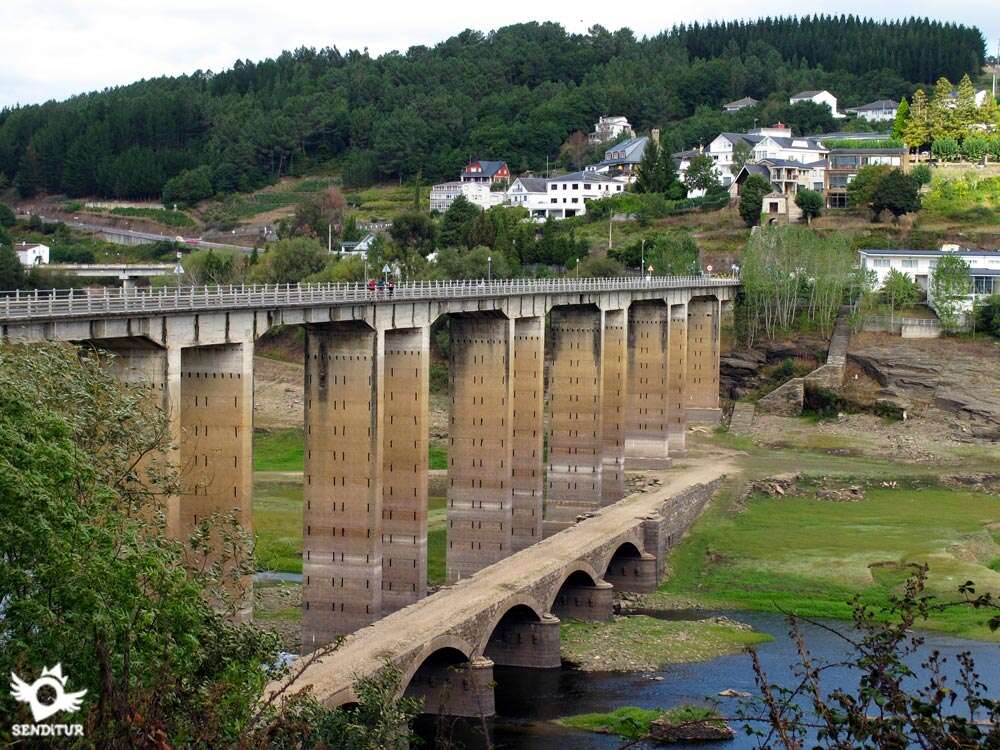
The route starts here the rapid descent to the valley of the Miño passing before A Parrocha and Vilachá, to precipitate in search of the small village of San Pedro. The dam of the Belesar reservoir, located 40 km downstream, causes the waters to flood this once fertile valley, giving it a special beauty and making us cross the long bridge that crosses this reservoir. In times of drought you can still see the remains of the old bridge that crossed the river at our feet, which should not be confused with the one that the Romans once created to reach the castro that gave rise to the old Portomarín, partly moved, along with its historical monuments, to its new location on Mount Christ, where this first stage of the Way of Saint James ends for some.
The relative comfort and short distance of the route added to the services that the different localities through which we pass, allows us to venture and lengthen the stage covering the scarce 9 km that separates Portomarín from Gonzar.
You can reach Sarria by following the LU-633 that joins it with Pedrafita do Cebreiro on the A-6, passing through Samos and Triacastela among other towns, this same road but in the other direction also connects it with the A-6, this time at the height of Becerreá, another branch of the LU-633 links Portomarín with Sarria. We can also do it following the LU-546 that reaches Sarria from the town of Nadela near Lugo, at the junction of the A-6 with the highway to Santiago de Compostela A-54. This same road in the other direction joins Sarria with Monforte de Lemos. The locality also has a bus station, located in Matías López s/n street and with bus lines that connect it with Lugo, Pedrafita do Cebreiro, Portomarín and Monforte de Lemos, as well as with nearby localities. There is also a train station on Calle Calvo Sotelo s/n, with daily stops on the Coruña-Madrid, Coruña-Barcelona lines, as well as other destinations such as Monforte de Lemos or Ferrol.
Simple stage without great unevenness and in general with good road surface that alternates different surfaces, in addition we will pass through a good amount of localities that, added to the wide areas of shade distributed by all the stage, do of this one a quite comfortable route for our friend. We must pay attention to the sections of road although normally they do not support too much traffic.
Provisioning and water should not be a problem since in almost all towns have fountains and places to get water or food, we will also cross several streams that will undoubtedly serve to cool if necessary.
Livestock are not as present as in other stages, as cultivation areas proliferate, although we can not rule it out altogether. We will continue to find loose dogs and also some roosters with sequito of chickens.
The final point of the Rúa do Peregrino in Sarria (0h 00min), marks the starting point of this stage that starts turning to the right and crossing the Rúa Benigno Quiroga for a few meters.

As soon as we turn we find the beginning of a new street where we have to continue.

In front of us we already have a considerable stretch of stairs that make us warm up quickly.

The cyclists have to make a small detour, following on their right the street that will take them to surround the block of buildings, to meet again the pilgrim on foot at the end of the flight of stairs.

The ascent does not end, forcing us to advance calmly because the slope, although softer, is still noticeable. We follow the Rúa Maior towards its highest part without paying any attention to the streets that come out to meet us.

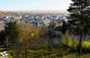
A hermitage and the ruined tower of the Battalion mark the moment to turn off and follow the street on the right that will take us to the privileged viewpoint from where we can contemplate Sarria.

This street that we traveled makes us advance without major complications, leaving behind us a road that joins us on the left.

Just as we arrive at the Monastery of La Magdalena, the Way of Saint James turns to begin a steep descent past the cemetery.

The quick descent ends when the cement track is found, which we go along with the road that cuts it, at which point we must turn right to continue for a few metres along the road.

Shortly afterwards we come across the medieval bridge over which the French Way crosses the River Pequeño. This old bridge takes us directly to the track that will be our companion for a while.

The railroad track can already be seen in front of us, forcing us, after a short time, to follow the course that marks us.

The path turns sharply away from the company of the railway, taking us unknowingly in search of the best place to cross it, hidden from our view for now by the vegetation and the high viaduct of the road.

Shortly after passing under the viaduct, we again come across the railway tracks and the level crossing, without barriers, through which we crossed them.

As soon as you cross to the other side, the route turns to the left to follow them again, but now on the other side. The slope of earth that sustains them is gaining height at each step leaving us embedded between it and the row of trees that delimit the path on the other side.

Luckily, the route comes across a small stream, which forces us to cross it, inciting us to follow its course, leaving the train tracks behind us.

We begin then an uncomfortable ascent that will make us gain height crossing a leafy forest that offers us its appreciated shade.

After a zigzagging of the path, which makes us change course for a few meters the route leaves the thickness that protected it to prepare to move between fields of pastures and crops.

After a while we are forced to change course again and turn right to continue with the approach to the first stop of the French Way.

The first buildings of this locality are already intuited even before the track we are progressing on is cut by a new road, this will serve to lead us to the locality.

When we reach it, we must leave behind the crossroads that leads to Raoña and continue straight on, entering Vilei (0h 55min).

After our entry into Vilei we find the first of the streets that continues on the right. As soon as we turn to continue along this street we see that it forks forcing us to decide between the two streets.

The route continues with the option on the left that takes us to the outskirts of the town. We then begin a new ascent that follows the course marked by the road, which will be the one that marks for a while the itinerary to follow.

In this section we find a first crossroads where we leave on the right the road that leads to a farm.

Soon there is another crossroads that we will leave behind us, although this time it is the road on the left that leads to Surriba. The ascent takes us without further complications to the crossroads with the access that, if we follow it, takes us to the nearby church of Barbadelo (1h 05min).

In this same place the route changes orientation leaving the access to Barbadelo on your back, to continue with the gentle ascent in the direction of the next passing place of the day.

This section, always by asphalt, leads us without paying attention to more detours until the proximities of the next village, moment in which we leave for now the road.

The track that we have followed joins almost at the moment with another track that also arrives from the road to join us in Rente (1h 25min).

The route through the town follows the course of its main street which turns right in its desire to return us to the road as soon as possible.

Rente extends accompanying us as we pass through it, making us leave behind us some street that invites us not to abandon it so soon.

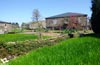
Almost without noticing it, we meet again with the road to continue with the discurrir that it marks us. A long stretch awaits us in continuous ascent that will take us to cross the fields of culture that will alternate with some wooded zone of whose shade, the days of heat, without a doubt we will enjoy.

After a while and without having deviated in any of the few occasions we have, we arrive at the final point of this asphalted part, which is marked by the encounter with a local road.

In front of us we can see the beginning of the dirt track where we must continue and that makes us leave on our right the village of A Serra (1h 25min).

Continuing along this track, protected for now by the shade of the leafy trees that mark it out, we arrive at a new crossroads that we cross to follow the straight line of the track we go along.

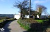
Soon we will find ourselves at another crossroads, where there is a Jacobean fountain and a small rest area. Here the route turns to the left, taking us through the green meadows that almost dominate the entire landscape.

Once again an intersection of roads alters our course, in front of us the walls that delimit a farm and to our right the track that we have to follow.

This part of the route gives us not only the shadow of the forest it crosses, but also one of the beautiful corners that the Way of Saint James has along its route. The track, perfectly defined, quickly leads us to the open field, letting us intuit the next town we will pass through.

As it could not be otherwise, it is the crossing with a road that marks the end of the track, we must cross the road to continue straight ahead by the asphalted track that leads us to pass next to it. A Pena (2h 10min) is on our left, just like the access that takes us to its interior.

At the moment we see ourselves in another crossing where this time we leave to our right the options that the place raises to us to follow the highway that will bring us closer to the following population of the many by which we will pass today.

Without further ado and after an almost imperceptible ascent, following the course indicated by the road, we reach Peruscallo (2h 25min).

The road that led us here is still our particular guide through Peruscallo making us travel the town leaving on both sides the streets and paths that we find.

The end of the houses also marks the end of the road that gives way to another typical Galician track between the walls that delimit the fields that surround us.

Once again, a small stream stands in our way, making us save it thanks to enormous stone slabs that act as an improvised bridge.

After a short while the track forks, being the option of the left the one chosen by the itinerary to continue with its advance. We begin a section in notable ascent that luckily does not extend too much.

As usual, we are alternating shady areas with open-field stretches between the different crops in the area. Almost without realizing it we see ourselves crossing the population of Cortiñas (2h 35min) following without deviating us the main track by which we arrived up to here.

The main track continues to serve as an improvised guide that avoids diverting us at any of the crossings we pass through.

On the outskirts of the town, the track splits again, and the option chosen by the French Way is once again the one on the left.

After a few metres we are forced to cross an asphalted track as the route continues straight between high walls and spectacular trees.

Our advance comes up against another asphalted track and it is at this point that we have to turn a few metres to the right in search of the continuation of the route. As usual from our arrival in Galicia, a narrow cobblestone path indicates the route to follow at these somewhat difficult crossings.

Without noticing it, we just passed by Lavandeira (2h 40min) and we advanced again surrounded by fields. The route leaves again to another asphalted track by which we must continue leaving to a side the buildings that border it.

We quickly embark on an elongated slide that will initially cause us to lose some altitude and then force us to make a greater effort when facing a steep slope.

The surface of the ascent has been improved by covering it with stone slabs and cobblestones that, if they are wet, do not help our progression too much. After the strong ascent the slope is losing inclination, although it still does not abandon us completely.

The track goes out again to another road which we follow until the nearby A Brea (3h 05min), which we enter immediately after leaving the asphalt. We must not fall into the deception of believing that we are already in the last 100 km, as well as marks the boundary stone at the entrance of the town. The real milestone is shortly after leaving the town, unfortunately the false boundary stone is much more careful than the real one.

The road is once again our guide, helping us to cross the town without any problems. After a new ascent, in which we will pass, now yes, next to the milestone of the 100 km, we have a gentle descent that brings us closer to Morgade (3h 15min).

Here, following the road as before, we reach its final point where we continue along the track that replaces it. The undulating terrain requires us to make uncomfortable progress, alternating between very muddy areas, with other cobbled areas and others with good road surface, but which do not contribute to our progress.

The track takes us through the meadows, leaving the paths that join them on one side and the other. The route is still embedded between the walls that delimit these fields and it is at one of these crossroads where the walls divide the path, making the route continue on the right.

When continuing with our itinerary we realize that if we had followed the other option we would have entered the interior of Ferreiros (3h 30min), this other option takes us by its side until a new entrance to the locality.

At this point on our right begins or ends, depending on how you look, the road that reaches the town being its layout the one we must follow.

This stretch of asphalt leads us after a new ascent to a new detour where they join another access to Ferreiros, ours and the road from where they both start. We turn a few meters to the left in search of the link that will take us to the road.

Once there we descend to the nearby village of Mirallos (3h 40min), to then begin the ascent that will take us to the next village to visit.

Again we have to take a small detour that leads us directly to A Pena (3h 50min), avoiding part of the road.

When you reach the interior of the town the route turns right to look for the protection of the road.

Again together we continue the course that indicates the layout of the road, leaving both sides the options that we are presented. A worked ascent that will transport us until O Couto (4h 00min) and at the moment until As Rozas (4h 05min).

After crossing this last locality we have to cross a short stretch until we find the detour where we leave the asphalt for a while. The itinerary now follows in part the outline of old corredoiras that serve us to recognize the route to follow.

There are quite a few crosses that we come across, usually access to the fields and forests that surround us. The track takes us without giving rise to error descending towards the next village through which we will pass.

The road gets between us and Moimentos (4h 20min), which we reach after crossing it. After our rapid passage through this small village, another relatively short stretch of road awaits us again.

Once again we must follow a dirt track that will avoid the long curve drawn by the road, leading us to pass through a good number of villages in a short space of time.

The first of them is O Cotarelo (4h 30min), without further detour we arrive at Marcadoiro (4h 35min) and then following the course of the track we are going to Moutrás (4h 40min).

Once again we see ourselves following the tiresome course that forces us to follow the road although luckily it allows us to enjoy some beautiful panoramic views of the valley of the river Miño. Without ever abandoning the asphalt, we arrive at a new detour, whose course to follow is once again marked by the cobblestone path that guarantees us the right course.

In this place we must deviate a few meters to the left to find the beginning of the dirt track that will make us continue with the descent at the same time that we recover the orientation that we took.

This track leads us to the confluence with another that joins us, and then we find the road, just at the entrance to the next town.

Luckily we will not touch the asphalt since the route continues entering A Parrocha (5h 00min).
The Way of St. James as it passes through the town follows its main street well marked by the water channel that runs through its center.

After leaving behind some streets we see ourselves finally leaving the locality and meeting again with the company of the road.

At the edge of a leafy forest is the beginning of the path that will help us to leave the road again. This track, in quite good condition, is perfectly delimited by the walls of the fields that we are crossing.

Even so, we will arrive at a point in which a path will join us on our right, and then separate again, this time leaving it on our left.

The entrance to Vilachá (5h 15min), as it could not be otherwise is preceded by the road that we will have to cross. Once again, an urban route awaits us, this time with some more complications, partly due to the discrepant number of signs.

Without deviating from the street you enter, leave the different streets you cross on both sides until you reach a stone wall where you must follow the street that turns to the left.

Shortly after the wall the route turns to the right to look for the outskirts of the town, it can help us to know that in case of doubt in all the crossings that we pass the option to follow is the main street that crosses the town.

After overcoming this last obstacle, we can see ourselves descending along an asphalted track that allows us to contemplate part of the Belesar reservoir, leading us to a new detour.

Here the route turns right again to quickly meet the road that cuts off your pass.

We will have to cross it to continue the advance already with the sight set in the end of stage that we can observe in our horizon.

The asphalted track turns towards the city we were contemplating and leaving the option that continues straight ahead. A winding and vertiginous descent awaits us that will lead us directly to the road, to which we will leave in full curve.

The French Way then continues to the left following the line it marks. It is important to look for the best place to cross because it is on the right side of the road where we will find the protection of the andadero and the quitamiedos that will escort us to the pass by the village of San Pedro (5h 30min).

Once again, a short ascent section that ends at the entrance of the bridge over which we will cross the reservoir that the Miño River has here.

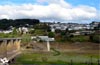
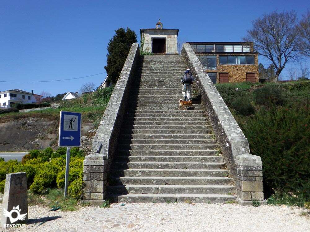
In front of us we can already observe the characteristic staircase that will give us entrance to the city.

In the case of cyclists at the foot of the staircase they have several options on both sides that will allow them to find the accesses that take them to the interior of Portomarín. Pilgrims who want to miss the visit to this beautiful town can choose to continue along the road on the left until they come across another bridge that crosses the reservoir and that is where the next stage will continue the Way to Palas de Rei.

After ascending the numerous steps and crossing the door, a hard, cobbled ramp awaits us that will take us to Avenida Sarria.

At our arrival to this avenue in front of us we have the street that will introduce us in Portomarín (5h 5min) and to our left the possibility of following the Way that turns in this point to continue the descending course of the street, by where we will leave in the next stage.
 Distance. 22.3Km
In any case, this figure is always approximate, as the start and end point of the stage taken as a reference will probably not be the same as yours.
 Time. 5:45h
Without great problems in the form of great slopes, the time that we will spend in crossing this stage can be extended in part by the possible, but short, detours that we will make to know the church of Barbadelo or the Castro de Paredes that should not suppose us a great increase of the total time.
 Time of year
Spring and autumn offer us in this tour a spectacular landscape, giving us surely a few days of good weather guaranteed. Summer, although it does not seem like it, marks temperatures that are nothing to envy to those that we can find in any of the Castilian stages, although here we have the advantage of counting on the protection that offers the leafy forests through which we pass. On the other hand, the winter shows all its harshness giving the route a special and solitary atmosphere.
 Material required
Footwear and hiking clothes according to the time of year and weather conditions, rainwear, equipped backpack, canes, canteen and food. It is advisable to wear boots since we will pass through muddy and waterlogged areas, in addition to the camera, sunglasses, sunscreen and cap that we can not miss. Consult our list of material and equipment to make the Way. Read more
 Difficulty. Medium
Physical
We don't have to fall into the error of thinking that this is a stage of the so-called flat stages, the ups and downs are continuous and we will have to face a few metres of unevenness, although those without the steep slopes of previous stages. A simple route for those seen so far that should not involve any complications given its relative short distance, its many shaded areas, and the greatest slope to face, we find in the descent to Portomarín.
Caution
Attention to our step on the stone slabs if we find them wet, as it is very likely that they skate more than expected. For the rest, we will only have to keep an eye on the sections of road, they do not have as much traffic as other routes before, but they are still roads on which the pilgrim is the first to take care of their safety. Another point to take into account is the passage over the bridge over the reservoir before reaching Portomarín, here there are some narrow sidewalks that free us in part of the traffic but there are not a few pilgrims who for different reasons ignore them and continue on the asphalt. The wind in this place if it can become a problem, so the days of strong wind will have to be attentive to prevent an unexpected gust of wind from frightening us.
Orientation
Generally well signposted, it is the excess of brands that want to take us to one or another place close to the Way that can complicate our day. The passage through the villages does not revert too many complications since in most cases we will cross them without deviating in any of its streets. The departure from Sarria, like any great locality, is the most complex of the stage, not counting the entrance to Portomarín, where once we have passed the typical stairs we will find ourselves in the middle of the avenue with no clear markings to indicate which way to go. If we don't spend the night in this town, which is well worth a visit, the Way goes back down to the reservoir to cross it again a few metres to the left of the bridge where we arrived.
 |
 |
 |
 |
 |
| 1-Sarria | 0:00h | 426m | 0Km | 29T 629827 4737208 |
| 2-Vilei | 0:55h | 520m | 3.8Km | 29T 627270 4736298 |
| 3-Barbadelo | 1:05h | 548m | 4.4Km | 29T 626794 4735986 |
| 4-Rente | 1:25h | 593m | 5.4Km | 29T 626076 4736209 |
| 5-A Serra | 1:40h | 628m | 6.2Km | 29T 625432 4736510 |
| 6-A Pena | 2:10h | 627m | 8.4Km | 29T 624076 4737504 |
| 7-Peruscallo | 2:25h | 634m | 9.4Km | 29T 623237 4737545 |
| 8-Cortiñas | 2:35h | 635m | 10.1Km | 29T 622686 4737258 |
| 9-Lavandeira | 2:40h | 644m | 10.4Km | 29T 622415 4737177 |
| 10-A Brea | 3:05h | 661m | 11.6Km | 29T 621397 4737412 |
| 11-Morgade | 3:15h | 652m | 12.2Km | 29T 620960 4737694 |
| 12-Ferreiros | 3:30h | 655m | 13.2Km | 29T 620271 4737856 |
| 13-Mirallos | 3:40h | 636m | 13.8Km | 29T 619712 4737842 |
| 14-A Pena | 3:50h | 644m | 14.4Km | 29T 619176 4738025 |
| 15-O Couto | 4:00h | 642m | 14.8Km | 29T 618841 4737938 |
| 16-As Rozas | 4:05h | 640m | 15.1Km | 29T 618613 4737846 |
| 17-Moimentos | 4:20h | 579m | 16.5Km | 29T 617471 4738170 |
| 18-O Cotarelo | 4::30h | 545m | 17Km | 29T 617058 4738344 |
| 19-Mercadoiro | 4:35h | 533m | 17.2Km | 29T 616883 4738445 |
| 20-Moutras | 4:40h | 535m | 17.4Km | 29T 616769 4738576 |
| 21-A Parrocha | 5:00h | 489m | 18.8Km | 29T 615492 4738898 |
| 22-Vilachá | 5:15h | 424m | 20.1Km | 29T 614195 4739045 |
| 23-San Pedro | 5:30h | 357m | 21.4Km | 29T 613442 4739700 |
| 24-Portomarín | 5:45h | 375m | 22.3Km | 29T 613111 4740217 |
Coordinates UTM Datum WGS84

 Slope: 1088m
 Slope +: 517m
 Slope -: 571m
 Maximum altitude: 665m
 Minimum altitude: 350m

This sketch of the route is not made to scale nor does it contain all the information relating to the area, it is merely indicative.

![]()
This schematic with the path is approximate and has been created from the derived cartographic base © Instituto Geográfico Nacional "Cuadrante 124 y 123 1:50.000".
Senditur has manipulated the tracks to correct the aberrant points that may exist, caused by problems with the reception of the GPS signal. In any case the tracks are always approximate. SENDITUR encourages you to use the new technologies within your reach, using them as support and consultation in your activity, not basing the realization and orientation of the same only and exclusively on them, since they may see their functioning altered by very diverse causes, not functioning correctly and their indications may not be precise.


Para muchos su primera etapa del Camino de Santiago, hacer los últimos 100 Km del Camino de Santiago sin duda tiene su mérito. En mi caso siempre que he hecho el Camino Frances lo he empezado en Saint Jean Pied de Port. Buen Camino!! Ultreia!!


Find out what to see in...
¿Did you know that...
The staircase at the entrance to Portomarín is formed by the only arch of the old Roman-Medieval bridge that remained standing after the flood that destroyed it in the 19th century. This arch was moved and reconstructed, housing in its upper part the chapel of Nosa Señora das Neves and becoming part of the exclusive symbols of the Way of Saint James.
Don't miss out...
In Portomarín the church of San Nicolás, erected in the old location of the locality by the monks and knights of the order of San Juan de Jerusalén as a church-fortress in the 12th century, was dismantled stone by stone to be relocated in its current location.


From the commitment of SENDITUR with Nature and the respect to the balance of the environment, SENDITUR urges you to travel in a responsible way, with low environmental impact and respecting at all times the Natural, Cultural and Social environment wherever you go.

Besides sharing with all of us your experience on the route we would be grateful if you could write to us to inform us of any erroneous or outdated information you may have found, or simply to let us know what you think at Thank you.
This route has been carried out in the field by SENDITUR on 09-10-2018. The route may vary greatly depending on the time of year, weather conditions and terrain, as well as the actions of third parties and the evolution suffered in the natural environment where it is located. All opinions, advice and/or assessments made by SENDITUR in their descriptions are for guidance only and are subject to and/or refer to the specific conditions of the specific day of the route, referring to that specific day, taken from trained people, with the appropriate experience and with a high level of physical and technical preparation as a reference, as well as correctly equipped.
All the times are approximate and take an orientative character, the stops have not been taken into account, no matter how small they are. All the information related to the route, texts, images, videos, maps, diagrams, tracks, towns, and places of tourist interest are published as a guide, and may not coincide with the current state of each place. Before undertaking any activity, assess your technical knowledge, your physical condition, find out about the weather and the variations that the route may undergo, equip yourself correctly, be prudent and responsible at all times, and do not exceed your capabilities. SENDITUR is not responsible for any misuse or inappropriate use of the comprehensive guides of its routes and/or publications as well as its electronic guides, nor for any variations in their descriptions for the aforementioned reasons, and recommends that everyone be responsible and prudent in carrying out the activity. We also encourage you to read books and specialised guides to complement the information described above.
Continue watching …


 Previous: Stage 24b Triacastela-Sarria por Samos
 Next: Stage 26 Portomarín-Palas de Rei