Welcome to SENDITUR.COM · paths · routes · tourism

![]() Difficulty-Moderate
Difficulty-Moderate
![]() 6:20 h.
6:20 h.
![]() 24.8 km.
24.8 km.
![]() Difficulty-Moderate
Difficulty-Moderate
![]() 6:20 h.
6:20 h.
![]() 24.8 km.
24.8 km.
In Portomarín begins the ascent from the plentiful valley of the Miño that will transport us through a good number of villages, next to the green fields and the rounded mountain range that house them. Rural Galicia is a land of deep-rooted customs and traditions that allows us to immerse ourselves in it as we travel this stage of the Camino de Santiago that will take us to Palas de Rei, which still preserves the trace of its flourishing stately past. A route in which we will be able to enjoy the beautiful panoramic that we will have to our step by the Mountain range of Ligonde and of the small corners loaded with Jacobean history that still are conserved scattered in the itinerary.

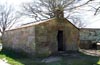
The stage 26 Portomarín-Palas de Rei of the French Way, with 24,8 Km, leaves from Portomarín, where we will not stop looking back in search of the silhouette of its church of San Nicolás of the XII and XIII centuries and remembering some of its palaces as the one of the General Paredes of the XVI century or its characteristic pazos, that like the church survived to the reservoir that flooded its old settlement. Going up the valley of the river Miño becomes a laborious task that will take us, among pine forests and fields, to slip through the first villages of the day as O Souto and Toxibó, until we can reach Gonzar, where the small church of Santa Maria awaits us. The rather short distance between the different localities make the route a continuous discovery of people and corners that will accompany us until the end of the stage. Castromaior and its simple Romanesque temple are the anteroom to our ascent to the Sierra de Ligonde, whose rounded peaks will envelop us from now on.

Hospital da Cruz old settlement that counted on hospital of pilgrims, is the following population that the French Way will take us to know. From here a continuous slide will take us to Ventas de Narón and its curious hermitage of La Magdalena, a place full of symbolism and stories of heroic battles against the Saracens at the gates of the Sierra de Ligonde. Although before arriving to this locality the small village of A Prebisa and the mythical cruise of the Pazo de Lameiros built in 1674 are waiting for us, whose particular design is worthy to dedicate a stop in the way. Ligonde shows us its marked pilgrim character at each step through the town, as the symbolic cross that marks the ancient cemetery of pilgrims. With almost no time to say goodbye to this town, we will find ourselves visiting the next one, Airexe, which shares with it its neoclassical church dedicated to Santiago.

We will continue with the succession of rounded hills that will lead us to Portos and shortly after Lestedo, in which we will pass next to another of the curious corners of the Way of Saint James, its church of Saint James or rather the cemetery in which it is located, which leaves part of its niches facing the road. From here and having decided before if we visit the Monastery of Vilar de Donas, a new succession of villages awaits us that will make us more pleasant the last kilometers. Os Valos or the small A Brea, where we will join the national bustling, are the anteroom of O Rosario, place from where you can contemplate the Monte Sacro or Illicino and that for years has been the place chosen by pilgrims from all over the world to pray a rosary before its slopes. The small village of As Revoltas brings us back to our final objective, which is none other than Palas de Rei, which we will reach after a rapid descent that will take us to this historic city surrounded by countless Celtic forts, vestiges of its ancient existence, this place being the point and followed by our French Way.
It is said that the Sacred Mount was formed thanks to a strange magician who roamed the area, a nobleman who passed through the place in search of peace and wisdom met the magician and he urged him to abandon his fabulous life and devote himself to the study and contemplation of the sky to achieve the wisdom and peace he longed for. The nobleman listened to him and dedicated the rest of his life to the study of the stars, at the end of his life he met again with the magician who gave him a spear saying "Throw the arrow and do not be afraid because where it ends your body will die and your soul will find the peace and wisdom you seek" The nobleman threw it and where the Sacred Mount fell, where the apostle was later buried.
This stage is more complicated than you would expect a priori, marked not only by the distance, within the normal, but also by the continuous ups and downs to which we have to add the effect that the asphalt can have on our friend. The layout of the stage with many crossings and many kilometres by road forces us to take extreme precautions to avoid disappointments.
Although we pass through quite a few towns, we should not lack water so that you can drink it if you need it. There are quite a few water points that we pass through but they are more concentrated at the end of the route. Luckily there are also several shady and rest areas where you can refresh if needed.
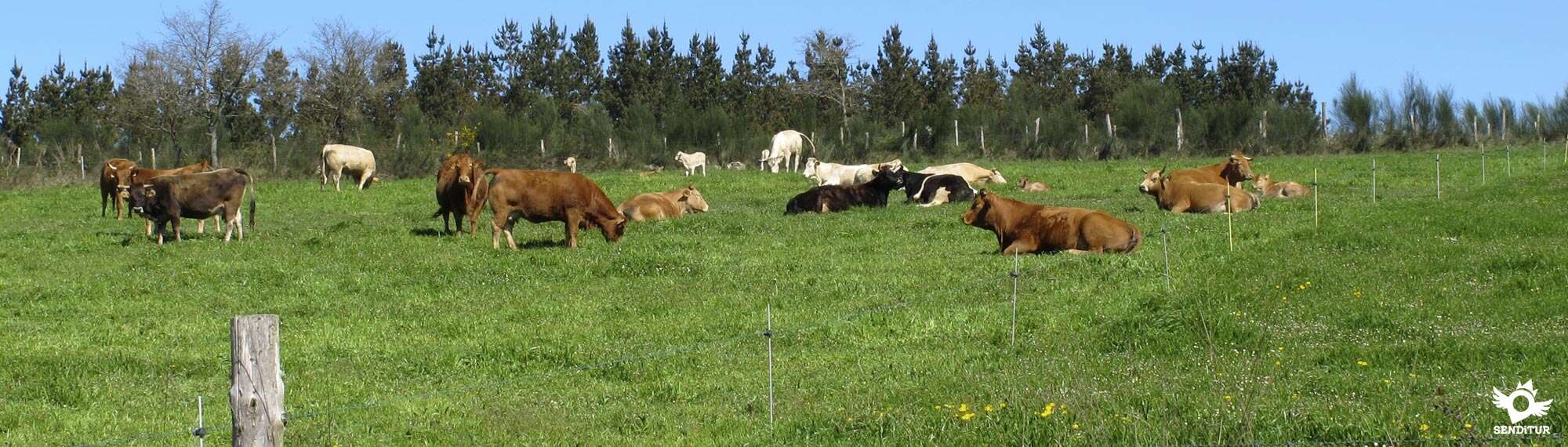
Cattle going from one meadow to the other, loose dogs wandering at will, the fauna of the area, including some snakes that come out to the heat of the asphalt, the usual thing that we can find in these stages that we carry, with the advantage that we pass through places with sufficient width and clear of weeds.
 |
 |
 |
 |
 |
 |
 |
 |
 |
 |
 |
| Portomarín |  |
|
|
|
|
|
|
|
|
|
| O Souto | | |||||||||
| Toxibó | | |||||||||
| Gonzar | |
|
|
|||||||
| Castromaior | |
|
|
|||||||
| Hospital da Cruz | |
|
||||||||
| Ventas de Narón | |
|
||||||||
| A Prebisa | |
|||||||||
| Ligonde | |
|
||||||||
| Airexe | |
|
|
|||||||
| Portos | |
|||||||||
| Lestedo | |
|||||||||
| Os Valos | |
|||||||||
| A Brea | |
|||||||||
| O Rosario | ||||||||||
| As Revoltas | ||||||||||
| Palas de Rei | |
|
|
|
|
|
|
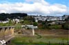
The square where the previous stage ended in Portomarín (0h 00min), serves as the starting bridge for this day.

Sarria Avenue now leads us past the cobbled road, a ramp that we used yesterday to reach the town.

Soon we see ourselves descending, leaving behind us little by little the last buildings of Portomarín and the different streets with which we crossed. The descent ends when we find the road that we left on the left yesterday to climb the staircase to enter the town.

The route turns radically as if it wanted to take us back to that place. In front of us we can already see the old footbridge, now unused, which previously crossed the French Way to save this bend in the reservoir.

A few metres further on we come across the bridge, which we will now cross to the other side, without the route allowing us to reach the staircase.

As soon as we cross, we are forced to continue on the right, following the course marked by the asphalt, taking us through the houses that make up O Souto (0h 10min). We also have the possibility of following another of the alternative routes that we will find along the Way of Saint James in Galicia, and which joins this itinerary a little further on.

This section already begins to show us what awaits us in a few metres, making us gain height for now without further demands. Shortly after leaving behind the houses of the small town, we find the end of the asphalt and the fork in the path we are following.

At this point we must continue on the left starting, now yes, the true ascent that awaits us and that will force us to take it with a certain calm. Luckily this part of the route runs largely in the shade of the trees that surround it, thus protecting us from the inclement sun that will undoubtedly harden the effort necessary to save this first hurdle.

The route continues its advance leaving to both sides some track that goes out to its encounter. Practically at the same time, the thick forest ceases to provide us with its pleasant shade and the demanding slope loses its inclination, allowing us to progress more easily.

The path, a well pressed and in perfect condition, makes us the perfect guide, marking without a doubt the path to follow.

The fields of pastures gain again the lost protagonism that in few meters it will have to share with the road, since the route returns to join us with her.

After reaching its height we see ourselves passing a crossroads to begin our journey along the path that continues on the left bank of the road.

The ascent ends when we reach the pavilions that house a brick factory, being in this place where we must look for the best time to cross to the other side, as the path now continues on the right side of the road.

A little more than a kilometre long stretch awaits us in front, with almost no unevenness, in which we follow the course of the road without detours, now with it on our left.

Other agricultural pavilions this time mark the time to cross the road again to continue on this side, this time for longer.

The pavilions remain behind us at the same time that, hidden among the trees, we can sense the next place we will pass through.

Once again we come across a narrow road that we must cross to ascend the track that will make us pass next to Toxibó (1h 30min).

This village and its accesses are to our left, almost without realizing we will see ourselves again crossing a beautiful forest that separates us from the hustle and bustle of the nearby road. The itinerary alternates the shaded areas with the open areas that allow us to contemplate the environment that surrounds us.

After a while following this track without deviating, we arrive at its final point, to our right we already see the road towards where we will go following the track that arrives from her.

Just when we reach her height we find the beginning of the walkway by which the route continues, forcing us to continue next to her. The Way of St. James is now embedded between the asphalt and the forest that alternates with the fields, ignoring the few crosses it encounters.

Sometimes the route separates us a few metres from the road, giving us a little respite, like the one offered by a shady rest area we pass through.

After passing through this oasis we went without further complications to Gonzar (2h 05min), which we arrived following the straight run that separates us from it.

The French Way goes straight on passing almost without approaching the town, leaving it on our left.

After a few metres, after leaving Gonzar on our back, we reach the end of the narrow path that takes us to a track that we must continue along.

As soon as we begin the route, we arrive at a dirt road on our right that makes us face a new ascent, this time less demanding than the previous one.

The route follows this well-defined track that will take us without problems until we reach the entrance road to the next town.

Again we see ourselves stepping on the asphalt, following the course of the road that leads us directly to the gates of Castromaior (2h 25min), getting into it without further delay.
The passage of the Way by the locality follows the ascending sense that marks the asphalt, ignoring the different streets and paths with which it meets.

Another hard ramp awaits us that will put us to the test, demanding an extra effort to leave Castromaior behind.

The ascent follows the course of the access road to the locality, taking us without a doubt until the reencounter with the road. Here we also have the possibility of following the itienrario that brings us closer to the old castro, at the top of the mountain, and then join a little further on to the route that usually followed the French Way.

When we arrive to its side, to our left begins again a narrow andadero that protected by a thick row of hedges serves us to continue with the ascent, that luckily already has lowered its intensity.

This section finishes faster than desired, forcing us once again to cross the road in search of its continuation to the other side.

As if it were a game, the andadero takes us without much consideration to the point where we are forced to cross the road again, this time for the last time.

On the other side begins a dirt track that, as soon as it begins, makes us leave a couple of paths to our left, to continue the road from afar.

The track transports us to the vicinity of the next town we cross and to which we arrive after a new crossroads.

Hospital da Cruz (3h 05min) returns to our left, while the French Way continues its course without major complication.

The route continues its course always choosing the options on the right in the few occasions in which it must choose.

The cobblestone street gives way to a new dirt track that takes us directly to a service road.

Following it in a soft ascent we see ourselves in a new crossing, in which we must cross the bridge that passes over the national 540.

As soon as we cross the bridge, the route begins a short descent as if to take us to the meeting of the national one. A little later we find the beginning of the road that we have to continue, starting at that point a new and hard ascent.

This local road accompanies us almost until the end of the stage, taking us through many villages and showing us from the beginning the type of stretch that awaits us, with continuous ups and downs that will make us save the rounded hills that stand in our way.

Luckily, or not, a large part of the route consists of what looks like a conditioned andadero that gives us some margin with the asphalt and the vehicles that pass through it. From now on, shaded areas are scarce, partly due to the fields of pastures and crops that dominate this part of the route.

At our entrance in the next locality we find ourselves with the possibility of following the course of the road to quickly turn left or take a small shortcut that takes us directly to the hermitage of Ventas de Narón (3h 30min), where both options come together again.

With no further divisions, the French Way continues its journey, leaving behind the hermitage and the small rest area next to it, to face another uncomfortable ramp, following the line that marks the road.

This section has a good number of paths that it leaves behind without leaving the road at any time. The route allows us to enjoy a varied landscape, offering us some area of shade that is very well received especially in summer.

The small village of A Prebisa (4h 00min) warns us of the proximity of the next town we will cross. But before that one of the many special corners of the Way of Saint James awaits us, formed by the curious Os Lameiros crossing and the surroundings that surround it.

Ligonde (4h 15min) surprises us almost without warning, taking us out of the green landscape that brought us here.
Accustomed to crossing quickly the localities with which we are with, Ligonde will take us more time than we imagined.

The locality extends around the French Way that advances leaving to both sides how many streets go out to its step.

The main street through which we cross the town is divided in its center by the channeling of water that serves as a reference to follow in case of doubt.

On the outskirts of Ligonde, just next to the municipal hostel, there is a small detour that avoids the long curve drawn by the road and which cyclists, with exceptions, cannot avoid.

The battered path takes us back to the meeting of the road to together start another strong ramp that takes us to the next objective of the day.

The asphalt introduces us without delay in Airexe (4h 30min), forcing us to leave aside the detour to its church.
As we pass through the town, we advance without turning off until we reach a large rest area, where the road divides in two, making us choose between both options.

The route continues along the road on the left, heading for a long, undulating section. The road continues to act as a personal guide, marking out the itinerary to be followed without letting us depart from its marked course.

The pattern of this stage is still in force making us face a tended ascent to descend again losing part of the height gained shortly after passing a lonely crossroads.

This descent takes us to Portos (5h 00min), a small village that offers us all its hospitality. From here a new ascent that gains inclination step by step. The road continues to make us leave behind as many crosses we find, facilitating the route to follow.

Lestedo (5h 10min) welcomes us with a fountain and its trough used now by pilgrims who refresh their battered feet in it.

The slope becomes somewhat more demanding without reaching the slope of past ramps, the road leads us leaving behind this town and heading towards the next from which we do not separate too much distance.

The route enters Os Valos (5h 25min) where it continues its gradual ascent. The locality extends following the line that marks the road that takes us without letting us leave it at any time.

We face the last stretch of road with hardly any inclination, this route brings us closer without knowing it towards the national road 547.

On reaching its height, the small village of A Brea (5h 40min) awaits us, where the itinerary forgets the asphalt that accompanied it until here to continue in principle by the cobbled track that starts from the village.

We have to save the rounded slope of the hill that separates us from the end of the stage, so we still can not say goodbye to the progressive ascent that does not finish abandoning us. The track transports us between the trees separating us for now from the national one.

We continue straight on at the few junctions that we encounter in our inevitable approach to the noisy national. The road joins us again, accompanying our progress along the path that borders it.

This stretch of track leads us to a crossroads with a road where we must go straight on to go towards the detour we will take.

The andadero ends when we arrive at O Rosario (5h 55min), which is on our right to follow the track that quickly takes us to As Revoltas (6h 00min).

The route crosses the town to begin the descent that will take us to the end of the stage.

Going straight on at the few crossroads we come across, we reach a large recreational area after which we continue straight on at the crossroads with the road that gives access to it.

The route begins a quick descent that ends next to the first houses of the city, where it turns to the right to enter little by little in her.

We leave a first street on our left to get closer to the one that will take us to the church.

Once there, cyclists must follow the street without deviating until its end, then turn left and link up again with the pilgrims on foot.

The rest pass by the church to meet the stairs that will lead them to the next intersection.

When we get to him in front of us we see the street we should follow and where we will be joined by cyclists who come from a little higher.

This new street takes us directly to the Palas de Rei (6h 20min) Town Hall building where this stage ends.

Next to him, on his right, we have the street where pilgrims who spend the night in another village later can continue.
 Distance. 24.8Km
There are several options for shortening or lengthening this figure.
 Time. 6:20h
Physical preparation will cause this figure to vary in both directions, as the profile of the route conditions more than we might think the total time we will need. For the rest and except for errors of course not so habitual or possible as in other stages we would not have to find greater problems to carry out the stage calmly in the marked time.
 Time of year
This route maintains its attractions almost all year round, offering a mixture of fields, wooded areas and rounded hills that combine a variety of colorful landscapes. The morning mists in the valleys or the wide, clear meadows will give us added value to a route that, without large mountains or mighty rivers, maintains the level of previous stages.
 Material required
Given the type of terrain and its good condition the stage allows us to use a footwear lighter than the usual boot. The material and clothing to wear as it could not be otherwise must be in accordance with the time of year and weather conditions that tend to be quite changeable in this area. Although we will pass many localities with their corresponding services, the water and some food can not miss us given the profile breaks legs of the entire stage. For the rest we must not forget the sunscreen, sunglasses and cap because the sun presses hard here even if it does not seem so. Consult our list of material and equipment to make the Way. Read more
 Difficulty. Moderate
Physical
Stage breaks legs, a continuous goes up and down with some hard ramp that added to the mileage make this stage harder than you would expect in the first term. The short distance between the towns and the relative influx of pilgrim-oriented services make this route somewhat more comfortable, which could be said to be largely by asphalt. The hot days, even taking into account the shaded areas that alternate on the route, will undoubtedly make the stage more demanding, forcing us not to forget to hydrate what is necessary.
Caution
The many road junctions and the traffic to a large extent through it make this a stage in which we must increase precautions. It is very common to find pilgrims who unconsciously forget that they are travelling on a road which, although local, has its own traffic and which, unfortunately, has been part of some accident or other. Attention on the little path after Ligonde, we are used to the good road surface of the stage and this short descent section is quite stark and if we add that for comfort we wear the lightest footwear can make us slip.
Orientation
Without major problems, since both the andaderos and the road are in charge of marking us very clearly the route to follow, even when passing through the localities. It is at the Portomarín exit where most of our doubts may arise as we partly have to go back and it is hard for us to find the marks at the beginning, especially for those who have not spent the night in this locality. The entrance to Palas de Rei for cyclists is somewhat more complicated as the Way follows streets with stairs, although it is relatively easy to recover its course.
 |
 |
 |
 |
 |
| 1-Portomarín | 0:00h | 375m | 0Km | 29T 613108 4740215 |
| 2-O Souto | 0:10h | 346m | 0.7Km | 29T 612795 4740135 |
| 3-Toxibó | 1:30h | 495m | 4.6Km | 29T 609243 4740885 |
| 4-Gonzar | 2:05h | 551m | 7.8Km | 29T 606587 4742353 |
| 5-Castromaior | 2:25h | 600m | 9.1Km | 29T 605521 4742937 |
| 6-Hospital da Cruz | 3:05h | 676m | 11.4Km | 29T 603488 4743873 |
| 7-Ventas de Narón | 3:30h | 701m | 13Km | 29T 602286 4744241 |
| 8-A Prebisa | 4:00h | 664m | 15Km | 29T 600501 4745167 |
| 9-Ligonde | 4:15h | 626m | 16.3Km | 29T 599680 4745867 |
| 10-Airexe | 4:30h | 627m | 17.2Km | 29T 599105 4746511 |
| 11-Portos | 5:00h | 580m | 19.2Km | 29T 597450 4747478 |
| 12-Lestedo | 5:10h | 596m | 19.8Km | 29T 596861 4747299 |
| 13-Os Valos | 5:25h | 633m | 20.7Km | 29T 596184 4747392 |
| 14-A Brea | 5:40h | 620m | 21.9Km | 29T 595058 4747683 |
| 15-O Rosario | 5:55h | 627m | 23.2Km | 29T 593846 4747563 |
| 16-As Revoltas | 6:00h | 628m | 23.4Km | 29T 593729 4747510 |
| 17-Palas de Rei | 6:20h | 554m | 24.8Km | 29T 592358 4747365 |
Coordinates UTM Datum WGS84

 Slope: 1034m
 Slope +: 607m
 Slope -: 427m
 Maximum altitude: 745m
 Minimum altitude: 346m

This sketch of the route is not made to scale nor does it contain all the information relating to the area, it is merely indicative.

![]()
This schematic with the path is approximate and has been created from the derived cartographic base © Instituto Geográfico Nacional "Cuadrante 123, 122, 0097 y 0096 1:50.000".
Senditur has manipulated the tracks to correct the aberrant points that may exist, caused by problems with the reception of the GPS signal. In any case the tracks are always approximate.oximados. SENDITUR encourages you to use the new technologies within your reach, using them as support and consultation in your activity, not basing the realization and orientation of the same only and exclusively on them, since they may see their functioning altered by very diverse causes, not functioning correctly and their indications may not be precise.


One of the oldest castles in the province of Lugo

Find out what to see in...
¿Did you know that...
The stage takes us into a region famous for its cheeses, more specifically those of the Arzúa-Ulloa type, being cheeses made using only cow's milk of the Galician blonde, Frisian, brown-alpine race. The region celebrates different fairs and festivities, such as the Festa do Queixo which has been held on the first Sunday in March since 1975 in Arzúa or the annual Cheese Fair held around Easter alternately between the concellos of Palas de Rei, Antas de Ullo and Monterroso.
Don't miss out...
The visit to the monastic Church of El Salvador, located in the town of Vilar de Donas, whose construction dates from the middle of the 12th century and which was linked to the order of the knights of Santiago keeping inside several tombstones of important knights of this order, in addition to other artistic treasures such as some Gothic frescoes from the 15th century. To visit this place we must take the detour that we will find between Portos and Lestedo that will take us to the locality after crossing the N-547. The return is made by the same route, extending in little more than 5 km the total distance of the stage.


From the commitment of SENDITUR with Nature and the respect to the balance of the environment, SENDITUR urges you to travel in a responsible way, with low environmental impact and respecting at all times the Natural, Cultural and Social environment wherever you go.

Besides sharing with all of us your experience on the route we would be grateful if you could write to us to inform us of any erroneous or outdated information you may have found, or simply to let us know what you think at Thank you.
This route has been carried out in the field by SENDITUR on 10-10-2018. The route may vary greatly depending on the time of year, weather conditions and terrain, as well as the actions of third parties and the evolution suffered in the natural environment where it is located. All opinions, advice and/or assessments made by SENDITUR in their descriptions are for guidance only and are subject to and/or refer to the specific conditions of the specific day of the route, referring to that specific day, taken from trained people, with the appropriate experience and with a high level of physical and technical preparation as a reference, as well as correctly equipped.
All the times are approximate and take an orientative character, the stops have not been taken into account, no matter how small they are. All the information related to the route, texts, images, videos, maps, diagrams, tracks, towns, and places of tourist interest are published as a guide, and may not coincide with the current state of each place. Before undertaking any activity, assess your technical knowledge, your physical condition, find out about the weather and the variations that the route may undergo, equip yourself correctly, be prudent and responsible at all times, and do not exceed your capabilities. SENDITUR is not responsible for any misuse or inappropriate use of the comprehensive guides of its routes and/or publications as well as its electronic guides, nor for any variations in their descriptions for the aforementioned reasons, and recommends that everyone be responsible and prudent in carrying out the activity. We also encourage you to read books and specialised guides to complement the information described above.
Continue watching …
 Previous: Stage 25 Sarria-Portomarín
 Next: Stage 27 Palas de Rei-Arzúa