The French Pyrenees and more specifically the Western Pyrenees National Park are home to a large number of natural monuments, one of the best known being the Gavarnie Cirque where the Waterfall of Gavarnie or The Great Waterfall as it is also known is located. A popular route that thanks to its relative simplicity, especially in summer, makes this spectacular place a meeting point for thousands of visitors who come here to enjoy a unique landscape, usually reserved for mountaineers who travel through the Pyrenees.

The 10.4 km route starts in the bucolic town of Gavarnie, from where we can already contemplate a spectacular panorama of what awaits us further on. From here, we will travel calmly through the town starting this beautiful excursion that will be impregnated with the Pyrenean atmosphere that surrounds us with every step. The route takes us little by little up the course of the river that is fed by the many creeks that arise in the mountains around us. The Mount Perdido Massif, on its French side, presents us with vertical walls and ancient glacial cirques formed by the passing of the years and the harsh conditions of these mountains.

Our pleasant walk through the valley will allow us to enjoy the lush beech forests or the wide green meadows that precede the vertical walls, some of them with more than 1000 meters of unevenness. The Gabietos, the Taillón, the Sarradets Peak or the Casco, next to the Marboré or the Waterfall, rise majestically before our eyes as we approach the impressive wall they form. The Hostel of the Cirque marks the point of separation between the more or less civilized and friendly mountain, and the mountain in its pure state, where after saving the steep terrain that separates us from it, we find the Waterfall of Gavarnie.

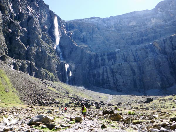
There are several reasons that make this Great Waterfall one of the most visited in the French Pyrenees, to the great beauty of the landscape that forms along with the mountains and the cirque that surround it, we must add the fact that it is, with its 423 m, the one with the largest waterfall in Europe. The height that the water must surpass in its impressive fall makes that this one practically vaporizes before touching the ground extending this way the beauty of the spectacle that we are contemplating.
Legend has it that Roldand, defeated by the armies fighting a unique battle against his army, wanted to break his Durandal sword with his last breath so that it would not fall into the hands of his enemies. To do so, he hit it with all his strength against the huge wall that cut his way, but instead of breaking it, he tore the rock, thus opening in it the famous Gap of Roldand. He then threw his sword into the void, disappearing to the bottom of the Cirque of Gavarnie where it is still hidden waiting to be found by the knight who is worthy of wielding it again.
To get to Gavarnie, you must follow the D921 road from Luz Saint Sauveur to Gavarnie, passing through Grède. It is in this village of Luz Saint Sauveur where the different roads converge, which either from, for example, Lourdes or from the A64/E80 motorway through La Pyrénéenne communicate Gavarnie with the rest of France. Similarly, from Bielsa, Biescas or Canfranc, following the roads that cross the Pyrenees from these towns, we can reach Luz Saint Sauveur and from there to Gavarnie. Once there we will find different places where we can leave our vehicle, for example on the same road just past the tourist office will have a large car park, also inside the town, at the beginning of the path to the waterfall will find parking areas, these paid.
Unfortunately, park regulations do not allow pets to pass through even if we keep them on a leash. We can obtain more information about the park's regulations from the tourist office and even ask for a permit that allows us to go on the route with our friend. It is not unusual to find pets on the route but if we have this authorisation we will avoid possible problems with the French gendarmerie who also tend to frequent the area.
As for the physical demand, it should not be a problem for our friend as long as he is used to walking in the mountains. The final scree, fortunately not too long, can cause injuries in the legs so it is not too much to take the protective boots just in case. It goes without saying that even with the proper authorization we must be careful not to leave him to his own devices since the terrain outside the marked route is not safe for him.
The water cannot be missing, we cannot count on the water we can find on the route since it is not allowed to leave the marked routes and the access to it is not easy in most places. Neither can we count on finding the bar of the refuge open as it closes in times of less public affluence.
Except for the cattle and pets that live in the lower part, the horses that tirelessly make the route from Gavarnie to the hotel and vice versa or the goats that bell at their ease, it is not very common to find more animals because the influx of people makes them be away from the route we follow. Moreover, with a few exceptions, given the park's regulations, it is not usual to find more pets on the route.
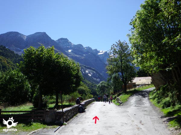
The route begins next to the tourist office of Gavarnie (0h 00min), in front of this office we have the street through which we must continue and that will take us through the town.

This first part of the route leads us, following this street, to the unmistakable Gavarnie Cirque.

Shortly after passing by the Pyrenees National Park interpretation centre, we find the crossroads where we must take a detour and head towards the impressive cirque wall and the Waterfall of Gavarnie.

We continue to move around the town enjoying the magnificent landscape that surrounds this small town. At the end of the street, and without any further detours, the track begins where we have to continue.

For the time being, the route takes us along a paved road, surrounded by the mountains and green meadows that characterize this route. We continue until we reach the meeting of a first bridge, here the route gives us two options. Cross the river and continue on the other side, leaving the dirt track on our right that runs parallel to us.

Or continue on this one, until we find the next bridge where both options come together again. On our way we find numerous trails that lead to the different corners that this place has. The river and the wall of mountains in front of us serve as a reference to follow, in case of doubt, in some of the crossroads that we are going to meet.

On reaching the height of the Pont de Nadàu, those who chose to continue straight on the previous bridge again have the option of crossing the river to join the other side. There is the possibility of continuing without crossing the river by following a steep trail that runs along the same bank, although the easiest and most comfortable option to follow is the one that continues along the wide path that goes up the course of the river on the other side.

From this point on the road begins to gain height without demanding a great effort from us for the time being. We continue with the ascent leaving the river further and further down, which continues its course down the valley while we go through a beautiful beech forest that hides the environment around us.

After this area of forest we start a rapid descent that takes us to a green meadow next to the inseparable company of the river. Here we find again a path that leads to our meeting after crossing this one and where the most intrepid who ventured along the trail on the previous bridge will join us.

After the pleasant walk in the meadow we will find another stretch of ascent that will ask us again, this time, a greater effort. This section is much longer and with a greater unevenness than the previous one, and it makes us gain height quickly following its winding route.

At the end of the hard ascent we will be rewarded with a spectacular view of the cirque and the Gavarnie waterfall. The end of the wide path coincides with the building that houses the Hotel of the Cirque of the Waterfall (1h 20min). From here you can see the route that draws the route, always in the direction of the base of the waterfall.

From now on, a well-defined path awaits us, which will make us gain height as we approach the wall of the cirque. Although this part of the route is perfectly marked, there are a good number of trails that lead to the different shelters and mountains around us, forcing us to be attentive to follow the right path.

We should not forget that we are in high mountain terrain, whose conditions should make us assess whether or not it is advisable to continue the route to the waterfall before entering a changing terrain that can play a trick on us.

The creeks that fall from the top of the walls of the cirque force us to look for the best place to cross them, although the path leads to the best place to wade through them easily under normal conditions.

The immense waterfall falls into the void before our eyes while we continue to advance towards it, looking for the one that is most comfortable for us out of the many trails we find.

This trail is sometimes marked by solitary stone landmarks that serve as a reference point in case of poor visibility.

The steep final stretch to the base of the waterfall forces us to take it easy, and allows us to take advantage of every stop to catch our breath and enjoy the magnificent scenery around us.

Once we reach the closest point, which is located at the base of the Waterfall of Gavarnie (2h 05min) we will start our way back following our steps along the cobbled path that goes down to the valley where the hotel is located and from there along the track that brought us there and that leaves us again in Gavarnie (3h 25min), where the route ends.
Our starting point will undoubtedly affect the distance of the route.
This time is usually longer due to the spectacular nature of the site we are visiting, which forces us to entertain ourselves by contemplating everything around us. We choose the side of the river that we choose to ascend the initial zone of the route, we will not see varied the total time of the route. Unless we venture along the trail that borders the opposite side of the road, in which case we will travel more distance and over less favorable terrain to advance quickly.
The location and the itinerary of the tour make it, depending on the time of year we choose to do it, a pleasant walk or a route that requires us to have certain experience and specific material to make the tour complete. Without snow and with the usual good weather that we find in the summer months and many days of spring and autumn we can enjoy the Pyrenean atmosphere that the route offers and the spectacular environment through which it runs. On the other hand, with snow, ice or bad weather, the initially simple route becomes more complicated for someone without the necessary experience or equipment, as well as increasing the time we have to spend travelling and the possibility of getting lost in case of fog.
Given the location and itinerary of the route, weather and terrain conditions can make the equipment we need for the tour vary considerably. With good weather conditions and without the presence of snow or ice is how the route is planned, so we will need a comfortable hiking shoes, boot or sneaker, nor is it superfluous some warm clothing or wind breaker, as the weather can vary quickly. Walking poles can be helpful both on the ascent ramps and for the descent section of the waterfall. Of course we can not miss the camera, sunscreen, hat, sunglasses and sunscreen, as well as some water and food as the hotel bar is not open all year. The binoculars can bring us closer to the summits and walls that surround us, where we can safely and with some patience discover some mountaineer progressing through them. It is not surprising that in Gavarnie we enjoy a pleasant or even hot temperature while in the surroundings of the Cirque the cold makes an appearance. Consult our list of material and equipment for hiking. Read more.
Physical
The relatively short distance of the route together with the fact that we find a unevenness distributed in two clear and differentiated parts, make this a route certainly accessible to almost everyone. The first area up to the hotel is a little bit more spread out so, if we take it easy on the hardest ramps, we shouldn't have major problems to get there. On the other hand, the section up to the waterfall and especially the final part of access to the Great Gavarnie Waterfall, where almost all the unevenness of this part of the route is concentrated, requires a greater physical preparation to face the last hard slope.
Severity of the environment
To the hotel we went along a wide dirt track that, except for a few slips on the way back to Gavarnie, should not mean any major complications as long as we do not abandon the route that it marks. We do not have to forget that we are in a changing environment so the conditions of the ground that we can find can be very different from one season to another. Where we must pay more attention is in the part of the route that connects the hotel with the Great Gavarnie Waterfall, as we go from a more or less civilized area to another pure mountain where we will find creeks to wade, scree to go up and down and trails to follow surrounded by vertical walls and large rocks, which although for someone used to this type of terrain do not mean anything more than the ante room to greater difficulties, it should not be underestimated especially for those who do not usually move through rough terrain.
Orientation
Well signposted at all times, the route follows the same pattern as in previous sections. Up to the hotel or refuge we only have to follow the marked path without deviating from it, while from here the few milestones and the imposing presence of the waterfall at the bottom of the cirque are the only references to follow in the different paths we will encounter. In case of fog it is not very advisable to venture into the final stretch as it is relatively easy to get lost and although all the streams can serve as a reference to find the exit from the cirque these can lead us to dangerous areas and complicated to overcome.
| 1-Gavarnie | 0:00h | 1370m | 0Km | 30T 744734 4735727 |
| 2-Hotel of the Cirque | 1:20h | 1565m | 4Km | 30T 745012 4732320 |
| 3-Waterfall of Gavarnie | 2:05h | 1791m | 5.2Km | 30T 745266 4731251 |
| 4-Hotel of the Cirque | 2:35h | 1565m | 6.4Km | 30T 745012 4732320 |
| 5-Gavarnie | 3:25h | 1370m | 10.4Km | 30T 744734 4735727 |
Coordinates UTM Datum WGS84

![]() Slope: 976m
Slope: 976m
![]() Slope +: 488m
Slope +: 488m
![]() Slope -: 488m
Slope -: 488m
![]() Maximum altitude: 1791m
Maximum altitude: 1791m
![]() Minimum altitude: 1370m
Minimum altitude: 1370m

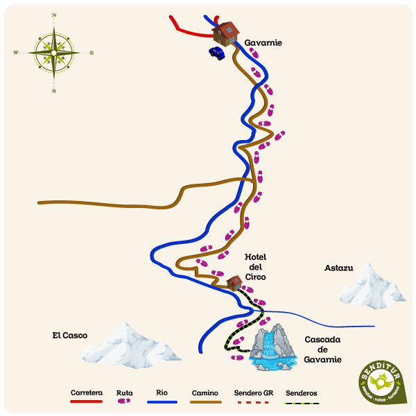
This sketch of the route is not made to scale nor does it contain all the information relating to the area, it is merely indicative.

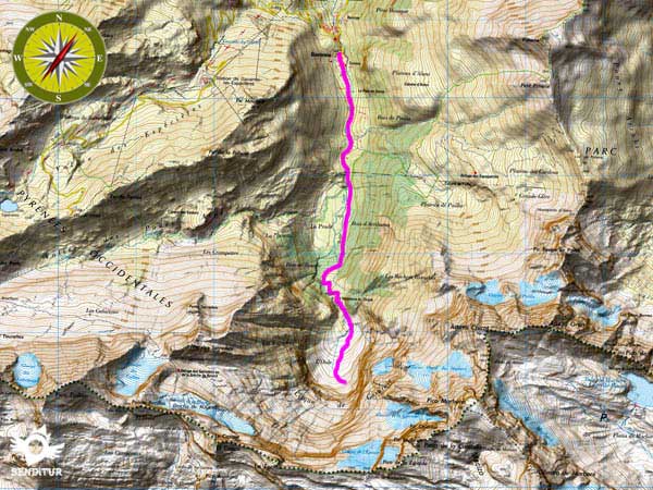
This schematic with the path is approximate and has been created from the derived cartographic base © Instituto Geográfico Nacional "Cuadrante 146-3 y 146-4 1:25.000"
Senditur has manipulated the tracks to correct the aberrant points that may exist, caused by problems with the reception of the GPS signal. In any case the tracks are always approximate. SENDITUR encourages you to use the new technologies within your reach, using them as support and consultation in your activity, not basing the realization and orientation of the same only and exclusively on them, since they may see their functioning altered by very diverse causes, not functioning correctly and their indications may not be precise.
¿Did you know that...
The Gavarnie Cirque is part of the Mount Perdido Massif, declared a World Heritage Site by UNESCO in 1997 and covering an area of more than 30000 hectares whose landscape includes deep canyons, large cirques and high mountains topped by the 3352 m high Mount Perdido.
Don't miss out...
The nearby Cirque de Troumouse, one of the largest circuses in the Pyrenees and Europe, which can be reached from the nearby town of Gréde. Its ease of access, the spectacular size and the magnificent landscapes inside, together with the low number of visitors, partly due to the fame of the nearby Cirque de Gavarnie, make this a place where you can enjoy an unbeatable setting.
From the commitment of SENDITUR with Nature and the respect to the balance of the environment, SENDITUR urges you to travel in a responsible way, with low environmental impact and respecting at all times the Natural, Cultural and Social environment wherever you go.
Besides sharing with all of us your experience on the route we would be grateful if you could write to us to inform us of any erroneous or outdated information you may have found, or simply to let us know what you think at Thank you.
This route has been carried out in the field by SENDITUR on 12-08-2016. The route may vary greatly depending on the time of year, weather conditions and terrain, as well as the actions of third parties and the evolution suffered in the natural environment where it is located. All opinions, advice and/or assessments made by SENDITUR in their descriptions are for guidance only and are subject to and/or refer to the specific conditions of the specific day of the route, referring to that specific day, taken from trained people, with the appropriate experience and with a high level of physical and technical preparation as a reference, as well as correctly equipped.
All the times are approximate and take an orientative character, the stops have not been taken into account, no matter how small they are. All the information related to the route, texts, images, videos, maps, diagrams, tracks, towns, and places of tourist interest are published as a guide, and may not coincide with the current state of each place. Before undertaking any activity, assess your technical knowledge, your physical condition, find out about the weather and the variations that the route may undergo, equip yourself correctly, be prudent and responsible at all times, and do not exceed your capabilities. SENDITUR is not responsible for any misuse or inappropriate use of the comprehensive guides of its routes and/or publications as well as its electronic guides, nor for any variations in their descriptions for the aforementioned reasons, and recommends that everyone be responsible and prudent in carrying out the activity. We also encourage you to read books and specialised guides to complement the information described above.
Continue watching …