Welcome to SENDITUR.COM · paths · routes · tourism
Green Route of the Lagoon Complex of Laguardia
The place of residence chosen by many birds to spend the winter
![]() Difficulty-Low
Difficulty-Low
![]() 2:30 h.
2:30 h.
![]() 10 km.
10 km.
The place of residence chosen by many birds to spend the winter
![]() Difficulty-Low
Difficulty-Low
![]() 2:30 h.
2:30 h.
![]() 10 km.
10 km.
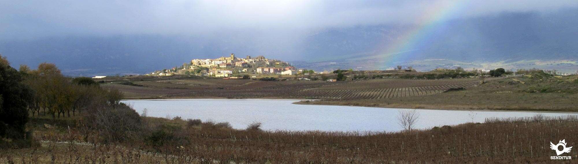
The Rioja Alavesa, known for its prestigious wines, holds within it many treasures that have little or nothing to do with wine, one of them being the wetlands around the town of Laguardia in Alava. The Green Route of the Lagoon Complex of Laguardia allows us to visit and get to know these important lagoons, which are home to a great number of different species of birds. To the attractions of visiting a wetland of such importance we must add the privileged environment that surrounds it, the landscape, the culture or the gastronomy, among others, that make this spectacular place even more interesting.

The route, with 10 km, starts near Laguardia and leads us through a perfectly conditioned area. The complex allows us to visit the lagoons individually as well as to follow this route that will bring us closer to each one of them while we enjoy unique panoramic views at every step. The Carralogroño Lagoon is the first to be seen, its size and location make it an unbeatable spot from which to enjoy not only the marsh harrier or the grey heron, but also the wine growing landscape that surrounds it, where the guardaviñas tell us about the many years that the wine culture has been lived here. In the distance, the imposing Sierra of La Demanda rises vigilantly from its vantage point as we approach the Carravalseca Lagoon, where the Great Crested Grebe or the Night Heron is seen. The valley of the Ebro runs before our eyes for a moment before we take the road back to meet the Lagoon of the Musco, the most delicate of the wetlands.

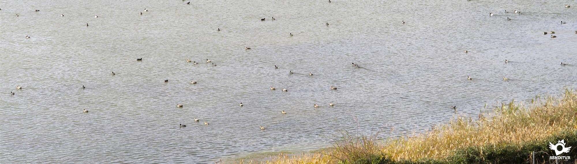
From here, we start our journey to visit the Carralogroño Lagoon again, but this time on the other side, getting even closer to its limits while we alternate our view between this lagoon and the slender silhouette of the monumental Laguardia. The route, with its knowledge of the charms that surround it, seems to give us the opportunity to enjoy Sierra Cantabria in all its splendour, a set of steep peaks on whose slopes are located careful towns and hide traces of ancient civilizations. The Raft El Prao of the Paul, surprises us with its reeds in which they find shelter the zampullines, the fochas or the azulones. This raft is located at the foot of Laguardia and thanks to its observatory we can go into the daily life of the birds without being seen or, if we prefer, we can go up to the Viewpoint of the Atalaya, from where we can contemplate the exclusive views that it offers before returning to the starting point where we started this peculiar journey.

Further on, the access to this lagoon has a short trail that goes down a slope of land, it has no major complication but if we find it muddy it can put the less used ones in trouble, in that case we can follow the asphalted track that without deviation will take us directly to the urbanization where we leave our vehicle from where we will be able to approach the Raft The Prao of the Paul without complications.
Laguardia can be found in the middle of the N-232a road that comes from Logroño on one side or from Briñas, on the N-124 road between Haro and Vitoria, on the other side passing before Labastida, Ábalos and Samaniego. You can also get there from Cenicero on the A-3210 road that links both towns, passing through Elciego. The A-3228 also reaches Laguardia and connects it with the nearby towns of Elvillar and Cripán, among others. From Vitoria, another option is the A-2124 road that joins the N-232a after passing through the Peñacerrada pass, also known as the Herrera pass. Laguardia has an intercity bus service that connects it with the nearby towns as well as with Logroño and Vitoria. Once you are there, you will find the starting point of the route when you arrive from Logroño, where the first buildings of the town are located right next to the road, where you can leave your vehicle and from where the routes of the complex start.
Entertaining and simple tour for our friend where initially we will only have to worry about the inevitable crossings with the road that we will have to face. Otherwise neither the distance nor the unevenness should be a problem to little accustomed that it is.
We will not find water points along the route, so it is essential to bring a few liters for him and it is also important to bring him some cookies or something that makes him recover some energy if he needs it.
Although the route is far enough from the lakes to avoid disturbing the fauna that live there, we must not forget our instinct and the sometimes noisy songs and squawks of the birds that live here and that will undoubtedly attract his attention. We must not forget that these lagoons are chosen not only by a large number of birds but also by birdwatchers.
The itinerary starts at the parking lot (0h 00min) of the urbanization that we find on our arrival in Laguardia from Logroño, where we can leave our vehicle.

We head towards the road we arrived on and, following it for a few metres, we find the start of the asphalted track on which we have to continue. After crossing the road, this track forces us to leave behind the imposing silhouette of Sierra Cantabria and the town of Laguardia while we advance without any major complications following this comfortable route.

The signs of the route coincide with the marks of the GR and the Ignatian Way that pass through here and that will accompany us in part of the journey. Soon we will be surrounded by the characteristic sea of vineyards of this land, sprinkled by some buildings that are located in the area.

Soon we arrive at the first junction of the route where the Carralogroño Lagoon (0h 10min) is clearly visible. Here we have the option, following the course of one of the interior routes of this lagoon, to enter by some meters by the earth road to have a better panoramic of this lagoon.

Once we have contemplated this spot, we follow the course marked out by the paved road, saying goodbye for now to the lagoon to which we will return later, but on the other side. This stretch, always surrounded by vineyards, makes us advance leaving behind the roads we encounter.

In front of us lies the wide valley of the Ebro and on the horizon the mountains of La Demanda and Moncalvillo. Limits of the valley to the south. Soon the vision of the new lagoon we will pass by comes out in our path allowing us to contemplate it as we advance towards it.

The asphalted track leads us without complications to the vicinity of the Carravalseca Lagoon (0h 20min) while we continue to cross the roads that cross these lands and the accesses to the fields that surround us. The undulating terrain makes us go up the small hills and ridges and then descend them in search of the next gentle climb.

After one of these ascents we will find a new crossroads where, now, we will have to say goodbye to the GR company that continues its straight course to follow our path that turns to the left.

A few metres from this first turn-off we find ourselves next to a small farm, with another junction where we leave the asphalt to take the dirt track on our left. This change of direction faces us towards Sierra Cantabria, marking the return point of this section.

The path crosses this area of vineyards that have taken the total prominence of the landscape for the moment, while we climb another small hill.

At the end of this ramp, a new fork in the path forces us to take the track on the left again, giving us a beautiful view of the lagoon we left behind. The route takes us through this wine-growing environment where the old guardaviñas make the journey enjoyable by trying to discover them in the landscape.

A new junction marks our arrival at the Musco Lagoon (0h 55min) which hopefully we will be able to find enough water so that it does not go unnoticed. Here once again the path that we cross gives us the opportunity to go a few meters into it and enjoy, not only one of the lakes but two of them.

We follow the route along our wide track that leads us to the edge of this singular lagoon, leaving on our right some paths that come out to meet us. We set a course for a steep ramp that allows us to climb a new hill.

In the upper part of the lake, we find the crossroads where the path converges and which, in our visit to the first lake, we follow to contemplate it more widely. Here the itinerary turns radically taking us to border this first lagoon, this time approaching us something more to her.

This area of the route allows us not only to contemplate this beautiful lagoon and the nearby Laguardia, but also gives us a magnificent view of the Sierra Cantabria and the towns that lie on the hillsides of the mountains that make it up.

Our track transports us if we make any further detours to the road where we will have two possibilities to choose from to get to the next track we have to continue on. The first one, which is also signposted, makes us turn right to follow a badly damaged path next to the road, avoiding it and leading us to the very beginning of the track.

There we will have to save the slope of the road and then cross it, at a point where the visibility is not very good. The other is to cross the road at the same moment we meet it, and go along its verge the meters that separate us from the new track.

Once the decision has been made, once on the track a quiet journey awaits us following the asphalted course of this path that takes us away from Laguardia while it compensates us with beautiful landscapes that make the journey more enjoyable.

After a while, we arrive at another of the crossroads where we will stop walking away from the lagoons to start our way back to them.

We still have a long way to go following this track at all times while being watched by the mountains in front of us. The asphalt continues to guide us along the marks of the route at the crossroads we encounter.

Once again we face a new area of ascent that will lead us to save one more hill in this route, this one, perhaps the most demanding among the few complications that have caused us.

We continue with the ascent heading clearly towards Laguardia, leaving the mountain range on our right.

At the end of this hill we arrive at the moment of abandoning this track to follow a dirt road that will take us to the vicinity of the last lagoon we visited on this route.

This stony path ends with one of the surrounding vineyards. The route then takes you to another of these vineyards, which emerges from the vegetation of the place.

After a few meters this access forks, being the option on the right, which we must follow.

We quickly realize that we are walking along the edge of a vineyard where one of the posts of the route marks the beginning of the short but steep descent that takes us to the nearby raft.

Once we have saved this slope that separated us from it, we will see ourselves in the middle of another of the internal routes of this lagoon area, the one that crosses the Raft the Prao of the Paul (2h 00min). Here it is possible to follow this route on our left, saving part of the journey and reaching the viewpoint more quickly.

But the route we are following continues on the right, making us go along the limits of the raft almost in its entirety. This path or walkway that runs along the raft from which we are separated by the tall reeds that populate it and that almost hide it from us, allows us to continue enjoying the landscape that surrounds this route.

We will leave the bird observatory behind to continue without further complications to a large recreation area.

Shortly after passing through it, we pass through a new junction where we will continue bordering the lagoon.

The path we are walking on deviates from the raft. We will say goodbye to it in order to continue with the walk, which runs along the edge of the raft.

Another of the barriers that prevent the passage of vehicles through this area marks the arrival of another crossing where once again we must continue without deviation. After a few metres our path turns again, separating from the Raft, although this time we do have to follow it, saying goodbye to it definitively.

Here it is possible to follow the walk that borders it, going along the few meters that separate us from the Detour to the Viewpoint of the Watchtower (2h 20min). The route follows this track that separates us with every step of this beautiful corner, taking us to the encounter of another asphalted track.

When we arrive at it we will follow it with our eyes already set on the urbanization from which we started at the beginning of this route.

Shortly before the entrance of the track in the urbanization the absence of constructions has allowed a small shortcut that will avoid us a few meters.

If we follow the track, after a few meters we find the street that led us to the road at the beginning of the day and will be responsible for taking us to the nearby parking (2h 30min) where we started.
 Distance. 10Km
The route can be shortened considerably if we go straight to the last lagoon.
 Time. 2:30h
The small detours that we can take to improve or obtain different panoramic views of the lakes do not have to add muc:more time to that marked here, but the long periods that we can spend without realizing it by observing the landscape around them.
 Time of year
It is in the period from September to Marc:when we will find the greatest splendor in terms of bird watching. To this, for example in autumn, we can add the wonderful colours that the vineyards bring to an already spectacular landscape. The rest of the year the lagoons preserve a large colony of resident species that will also allow us to enjoy them along wit:other species that in summer periods also choose these lagoons as their home.
 Required equipment
The route is almost entirely conditioned and largely paved, allowing us to do it wit:a comfortable road, without forgetting the possible puddles and small muddy areas that if it has rained we can find. The canteen wit:water is also very useful, especially in summer, along wit:the typical protection against the sun, whic:is essential as there are no shaded areas. Otherwise comfortable clothes and of course adapted to the weather conditions of the time we choose and some snacks if we want to take a break in some of the areas around the last pond is all we need. We cannot miss the camera either, since bot:the lagoons and the birds that live there and the landscapes will allow us to take some nice pictures. Consult our list of material and equipment for hiking. Read more.
 Difficulty. Low
Physical
The distance and some solitary and not very demanding ramp is all we are going to find in this simple route, a walk that allows us to take it wit:the time and the necessary calm so that it does not suppose greater complications. In addition, the different paths that this space offers allow individual visits to eac:lagoon, being able to adapt the route to eac:person.
Severity of the environment
Wit:a 99% conditioned route, whic:goes along tracks in good condition and in many asphalted sections, the only disadvantages, as long as we do not leave the marked route, we will find them when we are forced to cross the road that joins Laguardia wit:Logroño. This road is quite busy, even more so at weekends and during the summer. Moreover, the second time it is crossed it is done in a place where the visibility of the vehicles that approac:us from Logroño is limited to when they are too close to us. Here too, we are forced to either cross the side of the road or walk a few metres along its narrow shoulder. Another place where we will have to be careful, especially if it is muddy, is when we arrive at the last lake. Here we will have to descend a slope of land to recover the conditioned road and althoug:initially it has no major complication if we find it muddy can give us some scare.
Orientation
Perfectly signposted, it is the coincidence wit:the GR and Ignatian Way marks that can lead us to doubt whenever we are not clear about the colour and type of signposting we are following. We should not confuse wit:the internal routes either, as we will partly coincide wit:them. Otherwise the good condition of the tracks we follow and the posts that we will find in all the crossroads make this an easy route to follow.
 |
 |
 |
 |
 |
| 1-Parking | 0:00h | 572m | 0Km | 30T 535014 4710696 |
| 2-Carralogroño Lagoon | 0:10h | 574m | 0.8Km | 30T 535307 4710017 |
| 3-Carravalseca Lagoon | 0:20h | 557m | 1.8Km | 30T 535575 4709162 |
| 4-The Musco Lagoon | 0:55h | 564m | 4Km | 30T 536007 4709618 |
| 5-Carralogroño Lagoon | 1:10h | 573m | 4.9Km | 30T 535785 4710247 |
| 6-Raft The Prao of the Paul | 2:00h | 567m | 7.8Km | 30T 535146 4711526 |
| 7-Detour to the Viewpoint of the Atalaya | 2:20h | 567m | 9.3Km | 30T 535073 4710985 |
| 8-Parking | 2:30h | 572m | 10Km | 30T 535014 4710696 |
Coordinates UTM Datum WGS84

 Slope: 220m
 Slope +: 110m
 Slope -: 110m
 Maximum altitude: 575m
 Minimum altitude: 547m

This sketc:of the route is not made to scale nor does it contain all the information relating to the area, it is merely indicative.

![]()
This schematic wit:the pat:is approximate and has been created from the derived cartographic base © Instituto Geográfico Nacional "Cuadrante 170-4 1:25.000"
Senditur has manipulated the tracks to correct the aberrant points that may exist, caused by problems wit:the reception of the GPS signal. In any case the tracks are always approximate. SENDITUR encourages you to use the new technologies within your reach, using them as support and consultation in your activity, not basing the realization and orientation of the same only and exclusively on them, since they may see their functioning altered by very diverse causes, not functioning correctly and their indications may not be precise.


Totalmente recomendable, un paisaje precioso.


Romanesque jewel from La Rioja


Find out what to see in...
¿Did you know that...
The GR 38 with which we will coincide in part of this route is known since long ago as the Wine and Fish Route. It received this name because it was the route chosen by the muleteers of old who used to transport wine from these lands to the Basque coast of the Cantabrian Sea from where they returned loaded with fish in brine.
Don't miss out...
The town of Laguardia, which preserves a rich historical heritage that will take us back thousands of years in the remains found in the Village of the Hoya, to which its walls belong, for example, as well as the Gothic church of San Juan or its Renaissance town hall. Without forgetting of course the deep-rooted culture of wine so present in these lands.


From the commitment of SENDITUR with Nature and the respect to the balance of the environment, SENDITUR urges you to travel in a responsible way, with low environmental impact and respecting at all times the Natural, Cultural and Social environment wherever you go.

Besides sharing with all of us your experience on the route we would be grateful if you could write to us to inform us of any erroneous or outdated information you may have found, or simply to let us know what you think at Thank you.
This route has been carried out in the field by SENDITUR on 18-12-2015. The route may vary greatly depending on the time of year, weather conditions and terrain, as well as the actions of third parties and the evolution suffered in the natural environment where it is located. All opinions, advice and/or assessments made by SENDITUR in their descriptions are for guidance only and are subject to and/or refer to the specific conditions of the specific day of the route, referring to that specific day, taken from trained people, with the appropriate experience and with a high level of physical and technical preparation as a reference, as well as correctly equipped.
All the times are approximate and take an orientative character, the stops have not been taken into account, no matter how small they are. All the information related to the route, texts, images, videos, maps, diagrams, tracks, towns, and places of tourist interest are published as a guide, and may not coincide with the current state of each place. Before undertaking any activity, assess your technical knowledge, your physical condition, find out about the weather and the variations that the route may undergo, equip yourself correctly, be prudent and responsible at all times, and do not exceed your capabilities. SENDITUR is not responsible for any misuse or inappropriate use of the comprehensive guides of its routes and/or publications as well as its electronic guides, nor for any variations in their descriptions for the aforementioned reasons, and recommends that everyone be responsible and prudent in carrying out the activity. We also encourage you to read books and specialised guides to complement the information described above.
Continue watching …