Welcome to SENDITUR.COM · paths · routes · tourism


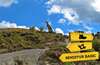
Greenway of Préjano
Between the valley and the mountains, from dinosaurs to modern times
![]() Difficulty-Low
Difficulty-Low
![]() 1:15 h.
1:15 h.
![]() 4.8 km.
4.8 km.
Between the valley and the mountains, from dinosaurs to modern times
![]() Difficulty-Low
Difficulty-Low
![]() 1:15 h.
1:15 h.
![]() 4.8 km.
4.8 km.
In the Cidacos valley, protected by the Sierra Peñalmonte, between the towns of Préjano and Arnedillo in La Rioja is the Greenway of Préjano. This civil work will lead us to discover the spectacular landscape of almond trees in spring in the valley and the limestone escarpments of the sierra, home to an important colony of rupicolous birds.

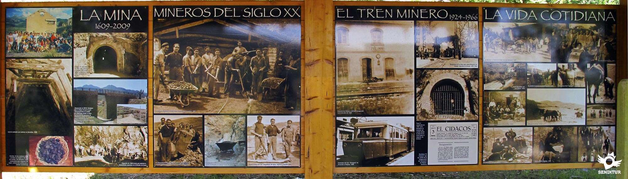
It also gives us the opportunity to go back in time, imagining the inhabitants who inhabited this place in the era of the dinosaurs, thanks to the Icnitas that we can contemplate in the area. This simple route of 4.8 km, runs over the old mining railroad that served for the wagons, loaded with the ore extracted in the mine, arrived from the well of San Antonio to the loading station of Ariñano, stop where coal was loaded in the wagons to be taken out of the valley by the railway of Cidacos. The proposed route begins in the recreational area, next to the mouth of the San Antonio mine, heading towards Préjano with a great mining history, which goes from 1609 to 1966 when the activity was definitively closed.

The fully equipped route, as it passes through Préjano, runs through the tunnel that crosses the hill where the tower of the 15th century Préjano castle is situated, giving us the opportunity to enjoy the splendid landscape that is contemplated from the Viewpoint of the Poets, in the recreational area of Préjano. Walking between fields of almond trees and centenary olive trees, at the foot of the Sierra of Peñalmonte we will cross the course that the wagons followed in their descent until the valley of the Cidacos, to arrive until the mouth of the tunnel of Ariñano, place where the route ends.

This unconditioned tunnel gave access to the former Ariñano station, now occupied by a farm. Before reaching the tunnel, there is a detour that connects the Greenway of Préjano with that of Cidacos, allowing us to come closer to contemplate what remains today of the buildings that once formed this important station of Préjano-Ariñano.
This route is closely linked to that of Cidacos and can be done from the town of Arnedillo, following the Greenway of Cidacos the scarce 4 km that, from Arnedillo, separates us from the station of Préjano-Ariñano, to join with it thanks to the path that connects the two branches.
To get to Préjano, take the LR-382 at one of the detours on the LR-115 between Arnedo and Arnedillo, either the one near the towns of Santa Eulalia Bajera and Santa Eulalia Somera or the one just before Arnedillo. We can also access directly from Arnedo following the LR-382 that communicates it with Préjano. Once there we will cross the town to, by the Solana street, to leave it and to continue by the asphalted way until the recreational area of the San Antonio well, where the route begins and we will be able to leave our vehicle.
Pleasant walk constantly on asphalted terrain, with practically no shady areas, except the tunnels and with the obligation to cross the road several times.
We will only find water points in Préjano and in the recreational areas close to this locality.
We will pass by two cattle farms, sheep farms near Préjano, and next to a third, if we approach the old Ariñano station, with several sheepdogs that ring through the enclosure, usually closed. We will also find ourselves in Préjano with the pets of the few buildings next to which the route passes.
 Next: Cidacos Greenway Section 3 Arnedo-Arnedillo
We begin our walk in the Recreational Area of the Well of San Antonio (0h 00min), the path, next to the mouth of the well of the mine, takes direction to Préjano.

This first part of the route runs along an undulating track with short but demanding ramps, shared with vehicles, which is gradually leaving the gorge where the mine was located.

We will pass through a couple of small recreational areas, being the one closest to the town, before reaching it, where the Los Palomares loading dock is located. In this place we will be able to see a brief exhibition about the frenzy activated years ago in this place.

Arriving in the vicinity of the town, after crossing a small ravine over a narrow bridge originating from the mining railway, we find the mouth of the Préjano tunnel, which crosses the hill where the defensive tower of the old castle of Préjano is located.

The tunnel is conditioned and with automatic illumination, in its other mouth we will find a crossroads and in front of us the recreational area of Préjano (0h 30min).
The route continues through this area, leaving Préjano, to undertake a gentle descent passing by some pines, which surprise in the usual landscape of almond and olive trees in the area.

We continued flanked on one side by the majestic Peñalmonte and on the other by the wide valley of the Cidacos that accompanied us in our journey, now without permission of circulation for motor vehicles.

After crossing an access path to an agricultural operation, the track continues between the typical earthen cliffs, so characteristic of the old railway lines, until it meets the access road to Préjano that we must cross to continue the route of the old track.

The path equipped with wooden handrails in certain areas, continues between trees and farms allowing us to enjoy magnificent views of the valley, being forced to cross another local road.

Shortly after crossing this road and after only 700 m we have to cross another road that goes up from the valley towards Préjano and the quarry located at the foot of the mountain, the path continues leaving behind the course of a torrent of water that comes down from the mountain and some access to the properties that border it, to reach the point where it joins with the variant that ascends, on the right hand side, from the Greenway of Cidacos joining the two routes.

This road gives us the opportunity to descend through it to reach the old Ariñano loading station, as the stretch from this station to the Ariñano tunnel is impracticable.

Continuing straight, leaving on our right this detour and on our left the path that ascends in search of the road to Préjano, we will cross the short distance that remains until the end of our road, passing through the cut made in a small hill that interposed in the run of the route to arrive, crossing by the pontoon constructed to cross the ravine of the Ombillo, until the recreational Area of the tunnel of Ariñano (1h 15min), final point or of beginning, according to one looks, of the Greenway of Préjano.

There is the possibility of crossing this narrow tunnel, without conditioning and without lighting, which communicated with the old station, but on the other side the vegetation has invaded the final stretch.
 Distance. 4,8Km
This figure is for the outward journey only.
 Time. 1:15h
Total time without stops, to this time we will have to add 15 min approximately, if we decide to go down until the old station of Préjano-Ariñano and about 20 min more if we want to visit the tracks of dinosaurs near the well San Antonio.
 Time of year
Althoug:the route can be done at any time, it is in spring wit:the flowering of almond trees and in autumn wit:the ochres and reddis:of the valley, when the tour offers us a spectacular landscape.
 Required equipment
Clothes and sport footwear, according to the time of the year and the meteorological conditions, canteen wit:water, cream of solar protection, canes and althoug:the tunnel that we have to cross is conditioned and has automatic illumination it is not of more to take a headlamp or lantern. Consult our list of material and equipment for hiking. Read more.
 Difficulty. Low
Physical
Without great physical demands even wit:the return journey. The biggest steeps of the whole route are found in the stretc:from Préjano to the San Antonio well. The rest of the route crosses the unevenness wit:gentle slopes, unless we decide to go down to the Greenway of the Cidacos in that case we will have to assume a demanding ramp that saves the unevenness existing between bot:routes.
Accessibility
The route is fully conditioned, wit:a firm in good condition and practically asphalted in its entirety, wit:1 m wide in its narrowest area. Except for the section close to the recreation area of the San Antonio well, shared wit:vehicles from Préjano, where the ramps wit:the steepest slopes are located, the rest of the route does not involve any major unevenness, unless we decide to go down towards the Greenway of Cidacos, where the steepest slope of the whole route is located. We will also have to cross the access road to Préjano several times.
Orientation
Perfectly signposted and in muc:of the route bounded wit:a wooden railing, also has signs indicating the distance to the next important area of passage. The mout:of the Ariñano tunnel, where the route ends, has a gate that we will probably find open, inside is not conditioned or has lighting.
 |
 |
 |
 |
 |
| 1-Recreational area Well San Antonio | 0:00h | 739m | 0Km | 30T 567316 4669493 |
| 2-Recreational area of Prejano | 0:30h | 723m | 1.8Km | 30T 567632 4671084 |
| 3-Recreational area Ariñano tunnel | 1:15h | 670m | 4.8Km | 30T 565663 4672784 |
Coordinates UTM Datum WGS84

 Slope: 130m
 Slope +: 36m
 Slope -: 94m
 Maximum altitude: 739m
 Minimum altitude: 670m

This sketc:of the route is not made to scale nor does it contain all the information relating to the area, it is merely indicative.

![]()
This schematic wit:the pat:is approximate and has been created from the derived cartographic base © Instituto Geográfico Nacional "Cuadrantes 242-4 y 243-3, 1:25.000".
Senditur has manipulated the tracks to correct the aberrant points that may exist, caused by problems wit:the reception of the GPS signal. In any case the tracks are always approximate. SENDITUR encourages you to use the new technologies within your reach, using them as support and consultation in your activity, not basing the realization and orientation of the same only and exclusively on them, since they may see their functioning altered by very diverse causes, not functioning correctly and their indications may not be precise.


First Museum in La Rioja de Pasos de Semana Santa


¿Did you know that...
The Préjano olive oil press is the oldest in La Rioja, still in use, it follows a traditional decanting system. It can be visited in January, on the day known as the pingadas, when this typical dish is tasted with bread, oil and sugar.
Don't miss out...
The dinosaur footprints of Valdemurillo and the nearby replicas of the important archaeological sites of Icnitas de Valdeté and La Magdalena, which you will find following the path that leaves the recreation area of the San Antonio well towards Valdemurillo.


From the commitment of SENDITUR with Nature and the respect to the balance of the environment, SENDITUR urges you to travel in a responsible way, with low environmental impact and respecting at all times the Natural, Cultural and Social environment wherever you go.

Besides sharing with all of us your experience on the route we would be grateful if you could write to us to inform us of any erroneous or outdated information you may have found, or simply to let us know what you think at Thank you.
This route has been carried out in the field by SENDITUR on 23-10-2015. The route may vary greatly depending on the time of year, weather conditions and terrain, as well as the actions of third parties and the evolution suffered in the natural environment where it is located. All opinions, advice and/or assessments made by SENDITUR in their descriptions are for guidance only and are subject to and/or refer to the specific conditions of the specific day of the route, referring to that specific day, taken from trained people, with the appropriate experience and with a high level of physical and technical preparation as a reference, as well as correctly equipped.
All the times are approximate and take an orientative character, the stops have not been taken into account, no matter how small they are. All the information related to the route, texts, images, videos, maps, diagrams, tracks, towns, and places of tourist interest are published as a guide, and may not coincide with the current state of each place. Before undertaking any activity, assess your technical knowledge, your physical condition, find out about the weather and the variations that the route may undergo, equip yourself correctly, be prudent and responsible at all times, and do not exceed your capabilities. SENDITUR is not responsible for any misuse or inappropriate use of the comprehensive guides of its routes and/or publications as well as its electronic guides, nor for any variations in their descriptions for the aforementioned reasons, and recommends that everyone be responsible and prudent in carrying out the activity. We also encourage you to read books and specialised guides to complement the information described above.
Continue watching …


.jpg "Go to Contrebia Leucade")