In the wide alluvial plain of La Rioja Baja, among fluvial forests, the river Ebro as it passes through Alfaro draws, with its sinuous course, a changing landscape, where the Grove of the Estajao is located. In the Natural Reserve of Groves of Alfaro we will enjoy a privileged environment, habitat of innumerable species both animals and plants.

The way takes us to cross the wandering course of the Ebro that conforms changing islands, "mothers", meanders and beaches of gravel, and next to the forest of bank, accustomed to the lows of summer and floods of the river, compose this natural space of great landscaping and ecological value. A comfortable itinerary of 6.2 km that begins in the car park next to the old Alfaro sugar factory, soon the path forks allowing us to approach the viewpoint of the Grove of the Nava if we continue along the main road, or descend by the one that goes to the recreational area, equipped with tables and benches, to meet again shortly after the path that comes from the viewpoint following the course of the Ebro, to continue in search of the Grove of the Estajao.

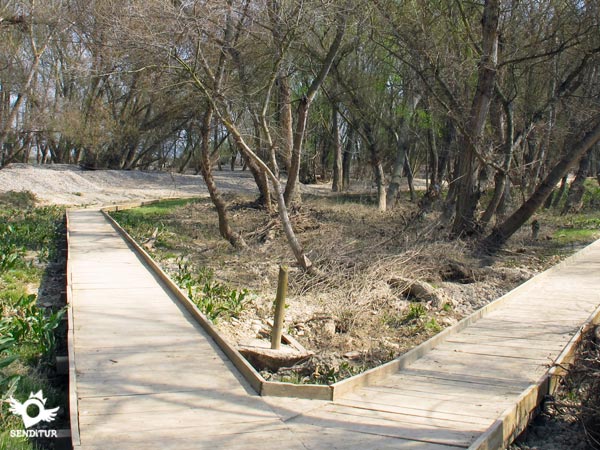
This floodable area, a wild enclave between crops and poplars, provides an entangled and lush vegetation being a dynamic ecosystem and refuge for various animals. Shortly after joining the two paths we will find a path that descends to enter the Grove of the Estajao, thanks to an elevated footbridge we can cross this magnificent space, its circular layout returns us to the main path. In this same place there is another path that will take us to discover the gravel beach of Estajao, a spectacular corner from where we can contemplate the Grove of the Duquesa, on the other bank of the Ebro. The main path continues along the meander between fields and poplar groves, being able to approach the Alhama river if we follow a path that starts right where our path turns sharply to the right. The final section runs parallel to the earth slope, which years ago was excavated by the Ebro, to go out to the path that goes to the recreation area or back to the car park.

The N-232 links Alfaro on one side with Calahorra, Logroño and on the other with Tudela and Zaragoza among other towns. If you take the LR-287 road towards Corella, you can also access the AP-68 motorway. The LR-288 connects it with the nearby town of Castejón de Ebro. Alfaro has a bus station and regular bus services that connect it with Logroño and Calahorra, as well as with nearby towns. There is also a railway station on the Logroño-Zaragoza line. From the town of Alfaro, leaving towards the railway station, as soon as you cross the river Alhama, turn left into the first street that we find, leaving the one that goes to the train station, continue along this street and after crossing the bridge that crosses the train tracks, continue straight on along the asphalted road that leads to the car park next to the old sugar factory. From here follow the signs for Grove of the Estajao that you will find.
Comfortable journey for our friends, on dirt roads in very good condition.
In the car park and recreational area we have water fountains, in the rest of the route we will not find more water points.
Remember that you are in a Nature Reserve, a protected area of special ecological value, find out about the regulations of the pet reserve. Try not to leave the signposted paths, without altering this space or disturbing its inhabitants.
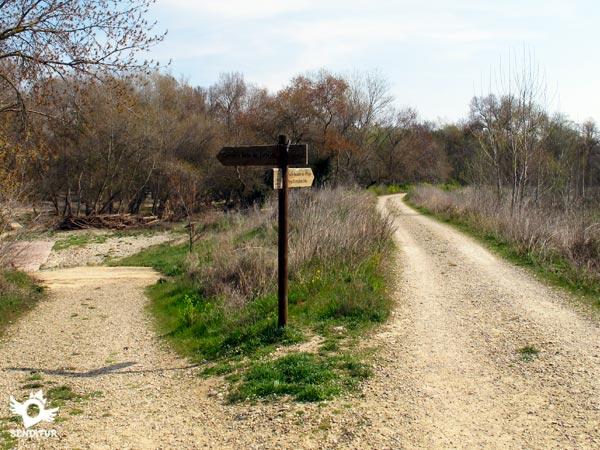
The route starts at the car park (0h 00min), next to the chimney of the old sugar factory. It runs along the path and, shortly after the start of the march, we find ourselves with a detour.

The path that goes straight on takes us directly to the viewpoint of Grove of the Nava and the one on the right, where we will return, descends towards the Recreational Area (0h 10min), leaving several more paths on the right.

These two paths meet again a little further on, giving us the opportunity, if we choose the option that passes through the recreational area and continues in search of the Ebro, to get close to the Viewpoint of Grove of the Nava (0h 25min), crossing the scarce 600 m that separate us from it.

If, on the other hand, we decide to visit the viewpoint first, we will travel along this path that starts on the right of it. Following the course of the river, the path introduces us to the Grove of the Estajo (0h 55min), to reach the height of a footpath that descends towards the soto, and that continues closer to the riverside forest until it goes out again to the path.

Once united again and shortly before reaching the curve that the meander forces us to make to our way, we will leave the path to descend a few meters to where the elevated footbridge begins to take us to the Grove of the Estajo. This footbridge has a circular route bringing us back to the beginning. Once back we will continue along the path we brought, continuing between poplars and farms of crops.

From this same place there is another path that will lead us to the gravel beach of Estajo, returning by the same path to the main road. A little further on, just where the path turns radically to the right, there is a path that would take us to the Alhama River, near its mouth.

We continue our march and shortly after we find a crossroads where we follow the path on the left. This section of the route runs through the old meander of the river, finding us with a couple of more crosses where we follow on our right, after going parallel to the slope of earth that the Ebro formed, reach the crossroads where we find the path that descends to the recreational area on our right or that ascends to the detour and the car park on our left.

Following the path on the left, leaving behind the option that comes from the viewpoint, we will arrive at the car park (1h 20min).
The route offers different possibilities that make this figure a variable reference.
This time includes the circular route by the footbridge of the interior of the Grove of the Estajo, if in addition we approach by the footpath until the beach of gravel we must add approximately 30min more.
We must bear in mind that the groves are undoubted areas, so in times of flooding it is advisable to inquire in advance at the interpretation center.
Footwear and sportswear according to the time of year and the weather. Consult our list of material and equipment for hiking. Read more.
Physical
A route with no physical demands, practically flat, except for the short ramp that descends near the car park to the recreational area, which also has a small car park that we can reach with our vehicle.
Severity of the environment
No difficulty, although if being an undoubted zone in certain occasions we can find some muddy or flooded zone, for that reason in time of floods it is advisable to be informed before the state and the forecasts.
Orientation
The paths and trails are in good condition well defined and signposted, on the way back that runs along the meander, between poplar groves and farms, it is possible to get lost as we cross three other roads, but they are signposted and the path of the grove borders it next to the slope of earth that the Ebro formed many years ago.
| 1-Parking | 0:00h | 275m | 0Km | 30T 604071 4671653 |
| 2-Recreational area | 0:10h | 267m | 0.5Km | 30T 604452 4671965 |
| 3-Viewpoint of Grove of the Nava | 0:25h | 269m | 1.3Km | 30T 604135 4672119 |
| 4-Grove of the Estajao | 0:55h | 266m | 3.3Km | 30T 605282 4672479 |
| 5-Parking | 1:20h | 275m | 6.2Km | 30T 604071 4671653 |
Coordinates UTM Datum WGS84

![]() Slope: 32m
Slope: 32m
![]() Slope +: 16m
Slope +: 16m
![]() Slope -: 16m
Slope -: 16m
![]() Maximum altitude: 275m
Maximum altitude: 275m
![]() Minimum altitude: 265m
Minimum altitude: 265m

This sketch of the route is not made to scale nor does it contain all the information relating to the area, it is merely indicative.

This schematic with the path is approximate and has been created from the derived cartographic base © Instituto Geográfico Nacional "Cuadrante 244-3 1:25.000".
Senditur has manipulated the tracks to correct the aberrant points that may exist, caused by problems with the reception of the GPS signal. In any case the tracks are always approximate. SENDITUR encourages you to use the new technologies within your reach, using them as support and consultation in your activity, not basing the realization and orientation of the same only and exclusively on them, since they may see their functioning altered by very diverse causes, not functioning correctly and their indications may not be precise.
¿Did you know that...
The groves are riverside woods that protect the floodable areas on the banks of the river from the great floods of the Ebro, filtering the water and retaining the soil.
Don't miss out...
You will find the interpretation centre of the Groves of Alfaro in the town centre in the square next to the town hall.
From the commitment of SENDITUR with Nature and the respect to the balance of the environment, SENDITUR urges you to travel in a responsible way, with low environmental impact and respecting at all times the Natural, Cultural and Social environment wherever you go.
Besides sharing with all of us your experience on the route we would be grateful if you could write to us to inform us of any erroneous or outdated information you may have found, or simply to let us know what you think at Thank you.
This route has been carried out in the field by SENDITUR on 03-03-2015. The route may vary greatly depending on the time of year, weather conditions and terrain, as well as the actions of third parties and the evolution suffered in the natural environment where it is located. All opinions, advice and/or assessments made by SENDITUR in their descriptions are for guidance only and are subject to and/or refer to the specific conditions of the specific day of the route, referring to that specific day, taken from trained people, with the appropriate experience and with a high level of physical and technical preparation as a reference, as well as correctly equipped.
All the times are approximate and take an orientative character, the stops have not been taken into account, no matter how small they are. All the information related to the route, texts, images, videos, maps, diagrams, tracks, towns, and places of tourist interest are published as a guide, and may not coincide with the current state of each place. Before undertaking any activity, assess your technical knowledge, your physical condition, find out about the weather and the variations that the route may undergo, equip yourself correctly, be prudent and responsible at all times, and do not exceed your capabilities. SENDITUR is not responsible for any misuse or inappropriate use of the comprehensive guides of its routes and/or publications as well as its electronic guides, nor for any variations in their descriptions for the aforementioned reasons, and recommends that everyone be responsible and prudent in carrying out the activity. We also encourage you to read books and specialised guides to complement the information described above.
Continue watching …