Welcome to SENDITUR.COM · paths · routes · tourism


![]() Difficulty-Moderate
Difficulty-Moderate
![]() 5:00 h.
5:00 h.
![]() 14.5 km.
14.5 km.
![]() Difficulty-Moderate
Difficulty-Moderate
![]() 5:00 h.
5:00 h.
![]() 14.5 km.
14.5 km.
There have been and still are many roads and trails that cross the mountains of La Rioja, which unite the villages and people who live there, and which are the real socio-cultural motors of the regions they cross. The GR 93 GR 190 Anguiano-Valvanera link officially unites these two Riojan routes by following the old path used by the inhabitants of Anguiano to make a pilgrimage to their monastery, home to the Virgin of Valvanera, the illustrious patron saint of La Rioja.

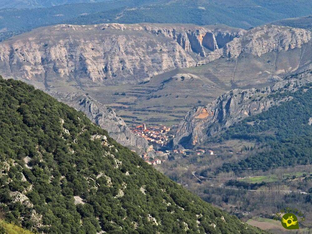
The 14.5 km route joins these two busy GR routes, on the one hand the GR 93 which crosses the south of La Rioja from west to east and on the other the GR 190, also known as the Highs Valleys Iberian and which from Ezcaray travels to Villoslada de Cameros, making an obligatory stop at the Valvanera Monastery. This route will allow us to calmly go up the course of the Najerilla River, towards whose valley the countless streams that we will encounter on our way will fall. Streams that have shaped the skirts of the mountains that run forming marked ravines like those of the Velilla, the Christ or the Rock, in which the vegetation that paints its slopes with striking colors grows strongly. Vegetable species such as beeches or oaks whose luxuriance will envelop us in many areas of this route and that little by little have been recovering the land given up to the old corrals used by the cattle and farmers that were and still are so common in this land.

An example of this is the Salegar Corrals, located shortly after our departure from Anguiano, and its remodeled Estopares Cabin, which shows us in a magnificent way what these traditional buildings, today fallen into disuse, used to look like. We follow this historical path of La Rioja putting ourselves in the shoes of the people who used to walk it, some of them out of devotion, others forced by the heavy cattle work, but all of them knowing the beautiful corner where the Monastery of Valvanera is located, towards which we go, not without first discovering the hidden places and the magnificent panoramic views that this route through the mountain range of La Rioja offers us while we fly over the Valley of the High Najerilla.

A little over 14 km of road separate Anguiano from the Monastery of Valvanera, so if our idea is just to cover this link without continuing the next day with one of the GR that joins, we can use two cars, leaving one in each place to avoid the 14.5 km back to the starting point. But if we feel energetic enough and have the necessary time, we can make a beautiful and intense journey back to Anguiano or Valvanera, as the case may be, through the Route of Valvanera that joins the monastery with the Pass of Cervanco and from there, following the Route of Three Villas, to reach Anguiano. Attention the route thus made is a total of approximately 30 kilometers.
The municipality of Anguiano is reached by following the LR-113 road that links Nájera with the Burgos town of Salas de los Infantes, also a few kilometres after passing through Anguiano, towards Salas de los Infantes we will find the detour that goes up to the Monastery of Valvanera. This same road, in Nájera, connects with the A-12, Autovía del Camino and the N-120, between Burgos and Logroño. There is also an extensive schedule of intercity buses that connect Anguiano with both Nájera and Logroño. Once in Anguiano, in the middle of the road that crosses the town we will find, at the exit of Anguiano towards Monasterio de Valvanera, a parking area where we can leave our vehicle and shortly after the street that takes us to the Bridge of Mother of God where the route begins.
Demanding route for our dog, so given its distance and the unevenness to overcome it is important that it has a good physical condition. Attention in the final part of the route that is by road already in the monastery, and usually there are enough people and vehicles.
The many streams we will encounter do not guarantee the availability of water, especially in the summer months. Due to the physical demands of the route, it is important to bring water and food to cover the wear and tear we will be subjected to.
The cattle, the bees in the area of the Cabaña de Estopares, and the hidden inhabitants of the mountains that we are going to cross, force us to be attentive to our friend at all times, as it should be normal.
The Bridge of Mother of God is the gateway to the GR 93 at Anguiano (0h 00min) and the starting point of the link that connects it to its brother, the GR 190 at the Monastery of Valvanera.

We begin the route following, as it could not be otherwise, the Valvanera street inside the Neighborhood of the Caves.

This long street leads us without detours to the wide Sun Square where we will continue on our left, leaving the square through one of the two streets that lead to the outskirts of Anguiano, the first one being the one officially signposted.

We quickly say goodbye to the town and begin our walk along the paved road that will guide us in this area of the route.

We follow the comfortable trail, leaving the Anguiano power station on our left, to begin the ascent of a hard ramp.

The paved track practically comes to an end after leaving behind a new path that, if followed, would lead us to the Benitones Dam.

The hard ramp is receding in its unevenness while we are now leaving behind the itinerary that follows the Route of Three Villas.

A long stretch of earthy track awaits us without major complications.

Without knowing it, we head for the first of the many ravines we are going to cross, in this case the one of the Encinar. So we cross this ravine and its corresponding stream to head towards a new crossroads.

On this occasion the GR marks make it very clear to us which way we should go. We begin a new stretch of ascent that will take us to the next crossroads we will encounter.

We continue without deviating, leaving behind us this junction and the path that goes up from the Benitones Dam.

Not much further on, the old Corrals of the Salegar and the Hut of the Estopares (0h 45min) await us.
After a short rest we say goodbye to this beautiful place to continue our route, which takes up again its ascending profile.

The road begins to lose its good condition as we walk through the remains of the old corrals.

Soon after, our path turns abruptly, at which point we must say goodbye to it and, following straight ahead, begin the footpath that will guide us from now on.

The unevenness, although not too noticeable, still does not give us a moment's respite. The narrow and sometimes cobblestone footpath cuts the side of the mountain leading us without a break to the Salegar Ravine.

We crossed the small stream to continue climbing this time up the slope of the ravine we used to see on our left.

This stretch of demanding slope allows us to observe the descending course of the Najerilla Valley and the corrals we had previously visited.

The trail takes us to the apex of the slope that separates us from the next ravine we have to pass through.

As we guessed, our trail changes course as we step on the shoulder of the mountain, heading for the Chorro Ravine. To our left we can already see the profile of the trail that we will soon be following.

Once again we will find ourselves wading the stream that runs down to the bottom of the valley to change direction again and continue the ascent.

As you had already warned us, this stretch of the trail demands us with its remarkable slope. The distant figure of Anguiano is left behind and we look at it again as an excuse to catch our breath.

The trail is undoubtedly heading for the best place to jump over the shoulder of the mountain.

Not without first drawing some small zigzags that indicate the near end of this hard stretch.

Luckily, after these typical curves, we arrive at a small sheepfold where we will not only recover our strength, but also enjoy magnificent views.

Having gained enough height, we crossed this area to continue with the trail that does not cease in its mission to travel the undulating slope of the mountain we are crossing.

We alternate areas whose slope is more benevolent with others that once again require us to overexert ourselves.

The trail on the vast majority of its route leaves no room for doubt and even allows us to contemplate its course later.

After a long walk we will be surrounded by the lush vegetation that precedes the next ravine to be crossed. But we still have a long way to go before we reach it.

On this occasion it is the Ravine of the Rock and its corresponding stream that stands in our path.

After crossing it we will have to face another demanding ascent zone that takes us in search of the next shoulder we have to save.

The thick vegetation continues to accompany us making the route even more beautiful. Vegetation that almost blurs the trail we are following.

After a while we will arrive at a new sheepfold, which we will cross, without almost changing course, to climb to the opposite side of the shoulder we have just jumped.

Once again, the trees surround us, hiding the view of the valley next to us.

And once again the vegetation hides from us the trail to follow, leaving us at the mercy of the marks of the GR that we find.

The Monastery of Valvanera is shown to us almost hidden by the trees, making us believe that the end of this path in La Rioja is closer than it really is.

After a while we will begin to lose some of the height gained, which indicates the relative proximity of the next ravine.

This tangled passage forces us to be vigilant in discovering where we should go next. We pass through the undergrowth to find the stream that has formed this Ravine of Peña.

We waded through the pertinent creek to start a tangled pass full of vegetation that covers the entire route.

We made our way through the bushes, sensing the hidden route of the missing trail. Luckily, soon normality returns and our footpath reappears allowing us to recover its marked course.

The slope gradually loses its intensity, allowing us to move forward in greater comfort.

Without almost noticing it, we will see ourselves going back up the course of a new ravine. In front of us are the different folds of the mountain that we will be forced to cross.

This ravine consists of different streams that feed the main one and that if or if we will have to cross.

After a while we arrive at the first of them and perhaps the one that most misleads us, since the old trunk of the fallen tree that crosses it hides the true aspect of this passage.

After saving the hidden trap of the creek, we start a fast up and down movement that will take us to the next channel to be crossed. Once crossed we can say that we are in the Ravine of the Velilla.

As soon as we pass through it we start, perhaps, the hardest ramp we have to face. A hard climb that seems to come to an end sooner than it actually does.

After a short break, including a descent, the footpath continues to bridge the gap that separates us from the last shoulder we have to jump over.

Although a good stretch of steep trail still awaits us, before reaching the fold that crowns this route of connection between GR.

Once up there, a greenish landscape opens up before us, which we must pay attention to in order to follow the course of the itinerary. Once at the top, a greenish landscape opens up before us in which we must be attentive to be able to follow the course of the route. Here you will come across one of the signposts for the Routes through Beech Forests, which invites you to turn off in search of the Valvanera Route. This route links the monastery with the Cervanco pass and from there with Tobía, Matute and Anguiano, allowing us to return to the starting point on an interesting circular route. We have to descend, turning off slightly to our right, in search of the markings that indicate the route.

When we reach the limits of the bushes we will find two options to follow and with the valley that to our right ascends towards Valvanera.

If we advance a little more we will discover how the route turns abruptly to begin with the footpath that will take us to the nearby monastery.

At the moment we start with the remarkable descent that awaits us through a leafy forest. The peaks of the mountains that make up the Sierra of Los Pancrudos serve as a reference to follow.

The long descent loses its initial intensity making us doubt the closeness of the monastery towards which we are heading.

Once again another green meadow opens up before us, forcing us to go through it. Here we have to be careful because the course to follow brings us closer, descending, towards the valley, instead of taking us as we have done up to now towards the summits of Los Pancrudos.

But the possible doubts that could have arisen, come to an end shortly after leaving the sheepfold, at which time the Monastery of Valvanera shows itself in all its splendour.

This final stretch is made up of several trails that seem to lead us more directly to it, but in all cases we must ignore its charms.

The descent takes us directly to the last of the ravines that populate this link of the GR 93 with the GR 190, the Christ Ravine. Now we only have to follow the descending course of its waters.

The Valvanera road awaits us after wading the stream that flows down the slope again. The asphalt is now responsible for making us climb the meters that separate us from the nearby monastery.

The regal building serves as an unbeatable finale to this route, which only has to go through the beautiful arcade of the Monastery of Valvanera (5h 00min).

Once we have crossed this passage of the monastery we will access the patio where this link joins the GR 190 to the GR 93 that we left in Anguiano.
 Distance. 14.5Km
Once past Cabaña Estopares there is no choice but to arrive or return along the same route.
 Time. 5:00h
It is almost certain that we will have a certain difference in time to travel the route in one or the other direction, given the marked profile that we have to face in ascending or descending depending on our course.
 Time of year
Spring and autumn are months of maximum splendour in these mountains, a colourful carpet paints, with the characteristic colours of each period, the slopes of the mountains and the valleys we walk through, making the landscape around us even more beautiful. The summer, or rather the hot days, can make the route harder than we think. In bad weather, snow, ice or fog, it is not too advisable to start walking, no matter how well signposted it may be.
 Required equipment
It is important to be aware when equipping ourselves and venturing out on this route that there are no possible escapes if we have any unforeseen circumstances, that is to say, we will not have any shortcuts or detours that we can take that will take us off the trail before we reach the monastery or the Estopares hut. Therefore, we will have to equip ourselves correctly with the necessary material, be foresighted and apply common sense. Consult our list of material and equipment for hiking. Read more.
 Difficulty. Moderated
Physical
For someone who enjoys the good physical condition that comes from regularly travelling this type of route, and always in normal conditions, we are faced with a route with a certain physical demand, both because of the distance and the unevenness, but which should not put you in great difficulty. Not being this way, when we do not usually move with certain frequency, the demand will be remarkable. The heat will undoubtedly make the physical difficulty of the route considerably harder, even if we enjoy sections with some shade.
Severity of the environment
Without the presence of mud, snow or ice, in which case we would be talking about a complicated route, it is the streams that run through the different ravines that we have to save and their slippery stones that would pose almost all the difficulties. It is worth mentioning one in particular which we will recognize by the trunk of the fallen tree that provides us with an improvised bridge over the course of the stream. If we look closely, we will see the fall that hides the trunk that has been accumulating the stones and the mud that the stream drags as a prey. It is true that the path crosses the steep slopes of the mountains along the route so we have to find areas subject to possible landslides that leave us more exposed than desirable, forcing us to assess the risk present in each place. As for the rest, the possible slips when we prepare to descend the steep sections that the path faces are how much we should suffer.
Orientation
Generally well signposted although there are some sections that may make us have some doubts, especially if visibility is reduced. This is an approved path and the red and white marks, typical of the GR, guide us without any major complications. The fold that precedes the beginning of the descent towards Valvanera is perhaps the point that will make us have more doubts. Another condition is the vegetation that can reach and hide part of the, on the other hand, stepped path. As it should be the usual thing, common sense should be enough to know that with fog or snow covering everything it is not very advisable to venture into these ravines.
 |
 |
 |
 |
 |
| 1-Anguiano | 0:00h | 644m | 0Km | 30T 519147 4678521 |
| 2-Hut of the Estopares | 0:45h | 760m | 3.3Km | 30T 516926 4677048 |
| 3-Monastery of Valvanera | 5:00h | 1000m | 14.5Km | 30T 510591 4675373 |
Coordinates UTM Datum WGS84

 Slope: 1156m
 Slope +: 760m
 Slope -: 396m
 Maximum altitude: 1214m
 Minimum altitude: 620m

This sketch of the route is not made to scale nor does it contain all the information relating to the area, it is merely indicative.

![]()
This schematic with the path is approximate and has been created from the derived cartographic base © Instituto Geográfico Nacional "Cuadrante 240-2, 240-4, 241-1 y 241-3, 1:25.000
Senditur has manipulated the tracks to correct the aberrant points that may exist, caused by problems with the reception of the GPS signal. In any case the tracks are always approximate. SENDITUR encourages you to use the new technologies within your reach, using them as support and consultation in your activity, not basing the realization and orientation of the same only and exclusively on them, since they may see their functioning altered by very diverse causes, not functioning correctly and their indications may not be precise.


Tramo nuevo de GR que une el Monasterio y Anguiano sin pisar carretera.- Fácil de andar y mejor en el sentido Valvanera (1.000 m)/Anguiano (665m). Apto para cualquiera que este dispuesto a andar 4 horas.

Me ha parecido una ruta muy bonita, fuimos en grupo y la impresión fue buena para todos.

Location of the Virgin of Valvanera, Patron Saint of La Rioja


Cradle of the Castilian and pantheon of the seven Castilian heroes

¿Did you know that...
There is a tradition, which has been repeated every year since 60 years ago, known as the Valvanerada, which consists of walking up from Logroño to the Valvanera Monastery, thus covering the approximately 64 km that separate them.
Don't miss out...
The visit to the monumental complex of the Monastery of Valvanera where, among other things, we cannot miss the Camarín de la Virgen, located behind the main altar, and the hermitage of the Christ of the monastery, located a short distance from the main building.


From the commitment of SENDITUR with Nature and the respect to the balance of the environment, SENDITUR urges you to travel in a responsible way, with low environmental impact and respecting at all times the Natural, Cultural and Social environment wherever you go.

.jpg)

Besides sharing with all of us your experience on the route we would be grateful if you could write to us to inform us of any erroneous or outdated information you may have found, or simply to let us know what you think at Thank you.
This route has been carried out in the field by SENDITUR on 10-04-2017. The route may vary greatly depending on the time of year, weather conditions and terrain, as well as the actions of third parties and the evolution suffered in the natural environment where it is located. All opinions, advice and/or assessments made by SENDITUR in their descriptions are for guidance only and are subject to and/or refer to the specific conditions of the specific day of the route, referring to that specific day, taken from trained people, with the appropriate experience and with a high level of physical and technical preparation as a reference, as well as correctly equipped.
All the times are approximate and take an orientative character, the stops have not been taken into account, no matter how small they are. All the information related to the route, texts, images, videos, maps, diagrams, tracks, towns, and places of tourist interest are published as a guide, and may not coincide with the current state of each place. Before undertaking any activity, assess your technical knowledge, your physical condition, find out about the weather and the variations that the route may undergo, equip yourself correctly, be prudent and responsible at all times, and do not exceed your capabilities. SENDITUR is not responsible for any misuse or inappropriate use of the comprehensive guides of its routes and/or publications as well as its electronic guides, nor for any variations in their descriptions for the aforementioned reasons, and recommends that everyone be responsible and prudent in carrying out the activity. We also encourage you to read books and specialised guides to complement the information described above.
Continue watching …
 GR93: Section 2 San Millán de la Cogolla-Anguiano
 GR190 Iberian High Valleys: Section 1 Ezcaray-Valvanera


.jpg "Go to Monastery of Valvanera")


