Welcome to SENDITUR.COM · paths · routes · tourism


Mount Aratz by the San Adrián Tunnel
Zegama, Guipúzcoa - Gipuzkoa![]()
![]()
![]()
![]()
![]() (1)
(1)
More than just a mountain ascent
![]() Difficulty-Medium
Difficulty-Medium
![]() 3:00 h.
3:00 h.
![]() 7.8 km.
7.8 km.
Zegama, Guipúzcoa - Gipuzkoa![]()
![]()
![]()
![]()
![]() (1)
(1)
More than just a mountain ascent
![]() Difficulty-Medium
Difficulty-Medium
![]() 3:00 h.
3:00 h.
![]() 7.8 km.
7.8 km.
The Aizkorri-Aratz Natural Park extends its domain between the provinces of Guipúzcoa and Álava. There are many natural and cultural treasures to be found there, megalithic remains, hermitages and sanctuaries or natural spots of incalculable value surrounded by the mythical Basque Mountains, peaks such as that of Mount Aratz, the natural border between both provinces of the Basque Country.

The route to ascend Mount Aratz by the San Adrián Tunnel consists of 7.8 km and takes us to visit emblematic and beautiful places. The track that starts from the Otzaurte pass takes us to the car park, from where we begin this ascent. A route that at the beginning takes us little by little to past times, like those experienced by the old refuge of San Adrián, an obligatory stop for muleteers and until not long ago for the mountaineers who crossed these mountains. The megalithic sites are also numerous in this area that we are visiting, a traditional grazing territory as verified by the GR 282 known as the Path of Shepherding.

But if there is something that attracts our attention without a doubt it is the San Adrián Tunnel, which we approach following the steps of the ancient pilgrims who, from the nearby Sancti Spiritu hermitage, walked along the ancient Roman road that crosses this symbolic tunnel. A tunnel in which the hermitage of San Adrián is located. For years, armies, muleteers and pilgrims, among others, have passed through this pass, also known as the Lizarrate Pass. The Roman road transports us through a leafy and colourful forest, so that when the time comes we can say goodbye to it and begin to climb the mountain in search of the limits of this dense forest. Once on clear ground, we are joined by the route that climbs from Araia to travel together the final stretch of the ascent to Mount Aratz, an unbeatable finale to this journey.

Legend has it that, many years ago, muleteers and shepherds did not venture into these mountains when the fog covered them because, according to the story, more than one who had done so had never been seen again. Those who returned told of their journey as if it were a terrifying nightmare. They wandered about in the thick, all-covering fog, tormented by the ghostly silhouettes which stalked them, until suddenly the fog was under their feet, and in front of them there was, drilled into the mountain wall, a terrifying cave which looked like the entrance to another world, and which they dared not approach.
On the road between the towns of Zegama and Altsasu, the latter on the A-1, we will find the Otzaurte pass and as soon as it is crowned by the asphalted track that leads to the Beunda recreational area. After passing through this natural area, the track continues to climb following the marks of the GR with which it shares the route. Along its route we will pass through different parking areas, and after approximately 4 kilometres we will reach the San Adrián Tunnel parking lot from where this ascent to Mount Aratz begins.
Nice route to take with our dog that, even if he is not used to it, he should not have major problems. Pay attention to the area of the tunnel as the cobbles can cause some injury.
From the forest we will not have water points where he can drink so it is important to bring some water and of course food.
We are in a natural park subject to its corresponding regulations that ask us to take it tied, in addition to good insurance we will find the cattle that governs the area.
The track from the Otzaurte pass leaves us, after four kilometres of asphalted road, in the car park (0h 00min) from where we start this climb to Mount Aratz.

Some lonely signs inform us about the different paths that pass through here and that have to accompany us in part of our route.

We will quickly be surrounded by the thick vegetation that populates this area of the mountain while we follow the marks of the Path of Shepherding the GR 121 and the SL GI 3003.

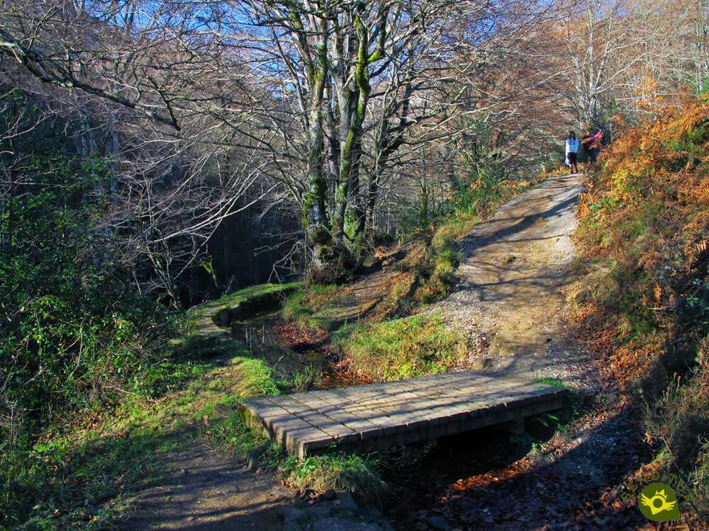
We quickly find ourselves crossing a small stream thanks to the wooden footbridge that crosses it. There will be several small bridges that we will have to cross in this area.

After doing so, we will begin to gain height by tackling the first of the steep ramps that await us.

With every step, the surrounding vegetation gives way, allowing us to contemplate the silhouette of the San Adrián shelter towards which we are heading.

Once again, when we reach this height, the signposting located there allows us to have all kinds of explanations not only of the trails that pass through here, but also of the historical importance that this territory used to have.

We continue ascending, already contemplating in front of us the unmistakable presence of the imposing mountain pass to which we are heading, while we leave on our right the Ermita Sancti Spiritu from which the ancient Roman road arrives towards us, with which we are about to coincide.

Shortly before reaching the tunnel that awaits us further on, we will put ourselves in the shoes of the ancient pilgrims who frequented these lands following this important Roman road.

A roadway that takes us without further ado to the very entrance of the San Adrián Tunnel (0h 25min).
Once in the tunnel, in addition to the small hermitage of San Adrián, which is located inside it, there is a generally slippery pass that will take us to the other side of the mountain that was in our way.

The Roman road continues to guide us on this part of our route which now runs through the Lizarrate countryside.

Another more than populated signpost marks the moment to say goodbye to the SL GI 3003 that continues its journey towards the magnificent viewpoint that invites us to visit.

We do not leave the old Roman road which leads us into a beautiful and colorful beech forest.

Roman road that we will leave a few meters later to resume the ascent. We will see ourselves again making an effort to gain height while enjoying the leafy forest we are going through.

The leaf litter hardly lets us intuit the path that we must continue to force us to be attentive to the marks that indicate it.

A few marks more difficult to see in this sense than when we are returning from the peak we are heading for.

The typical stone milestones and the yellow circles that mark our route confirm the path to follow.

After passing under the power line that crosses these mountains, in a clearing in the forest we will find another post that indicates the route.

We'll still have to be on our toes to follow the right course through the forest.

A forest that reaches its end leaving us already in full ascent to the first of the peaks that precede the Aratz.

A long stretch of hard ascent awaits us, during which we can contemplate the magnificent landscape that surrounds us.

After overcoming a first steep slope we will come across a new sign that warns us of our arrival at the crossroads with the path coming from Araia.

Not much further on we will leave on our left the detour (1h 20min) that, if followed, would also lead us to the top of Mount Aratz, a detour that already at the summit we can see as it is marked by the yellow circles that mark the return.

We continue without deviation, confronting the hard slope before us that will lead us to crown the second of the peaks that precede the Aratz.

After doing so, our objective is already shown before us, allowing us to contemplate the land that separates us from it, much less demanding than the previous stretch.

The trail leads us along the crest that separates us from the summit we are about to conquer without any difficulty.

The Aratz Mount (2h 00min) rewards us for the effort made with unbeatable views. From here, after a well-deserved rest, we return either on our own steps or by following the yellow circles that will lead us along the side of the mountain to the junction with the Araia path, where both options come together again and together we return to the car park from which we set off.
 Distance. 7.8Km
Low parking capacity may force us to park further away from the start of the route, thus extending the final distance.
 Time. 3:00h
This time is counted taking as a starting point the car park closest to the San Adrián Tunnel so it can be seen quite extended if the route cannot be started in that car park.
 Time of year
Covered by the blanket of snow, it is a marvel but the tour is practically reserved for people with the necessary experience and equipment. Fogs are also very common, adding a special touch to the landscape. The spring and especially the autumn increase the landscape value of this itinerary since it has a great part of its running through the interior of a beech forest.
 Required equipment
Given the proximity and reputation of the San Adrián Tunnel, many people are encouraged to visit it as a place of tourist interest, which it undoubtedly is, without taking into account that it is in the middle of the mountain and without realising the generally slippery and cobbled terrain that characterises it. Footwear and hiking clothes, GPS with the route in case we are surprised by the fog, trekking poles to help us in the climbs and give us more stability are just some of the accessories that have to accompany us. Consult our list of material and equipment for hiking. Read more.
 Difficulty. Medium
Physical
The unevenness to overcome, with ramps of certain entity is, in normal conditions, the factor that contributes much of the difficulty of this mountain route. If we add to this the total distance of the route, it forces us to have a good physical condition.
Severity of the environment
We should not be fooled by the apparent security provided by the many routes that run through here. In the area of the tunnel, besides the slips that wet stones can cause us, we are also exposed to possible falls of stones. The mud is another of the usual protagonists of much of the route can get to put us in some trouble. Of course, another area to take into account is the final part of the ascent, since if we do not choose the right route we may be exposed to more than necessary.
Orientation
Well signposted along almost the entire route, it is the multiple routes with which we will coincide that can generate doubts if we have not prepared the route beforehand. The ascent section after leaving the Roman road behind is the one that will cause us the most complications because the trail to follow is not well defined in a large part of the forest, and there are no good signs. Signs that are only clearly visible if we are descending.
 |
 |
 |
 |
 |
| 1-San Adrián Tunnel Car Park | 0:00h | 836m | 0Km | 30T 556822 4753823 |
| 2-Hermitage and Tunnel of San Adrián | 0:25h | 1025m | 1.3Km | 30T 555848 4753840 |
| 3-Detour | 1:20h | 1280m | 3.1Km | 30T 556321 4752874 |
| 4-Aratz | 2:00h | 1445m | 3.9Km | 30T 556731 4752270 |
| 5-Detour | 2:15h | 1280m | 4.7Km | 30T 556321 4752874 |
| 6-Hermitage and Tunnel of San Adrián | 2:45h | 1025m | 6.5Km | 30T 555848 4753840 |
| 7-San Adrián Tunnel Car Park | 3:00h | 836m | 7.8Km | 30T 556822 4753823 |
Coordinates UTM Datum WGS84

 Slope: 1370m
 Slope +: 685m
 Slope -: 685m
 Maximum altitude: 1445m
 Minimum altitude: 830m

This sketch of the route is not made to scale nor does it contain all the information relating to the area, it is merely indicative.

![]()
This schematic with the path is approximate and has been created from the derived cartographic base © Instituto Geográfico Nacional "Cuadrante 113-2, 25.000"
Senditur has manipulated the tracks to correct the aberrant points that may exist, caused by problems with the reception of the GPS signal. In any case the tracks are always approximate. SENDITUR encourages you to use the new technologies within your reach, using them as support and consultation in your activity, not basing the realization and orientation of the same only and exclusively on them, since they may see their functioning altered by very diverse causes, not functioning correctly and their indications may not be precise.


Esta ruta es una de las que más me gustan del parque natural y subir al Aizkorri también merece la pena.

Where the highest peaks of the Basque Country can be found


Between the mountains and the Middle Zone of Navarre

Home of the Patron Saint of Alava, a jewel of Alava's Romanesque style.


Jewel of Romanesque architecture, centre of spirituality

¿Did you know that...
This territory belongs to the Parzonería General de Guipúzcoa y Álava, an entity that has regulated the shared use of the mountains and resources that make it up since the past. It is made up of the municipalities of Idiazábal, Segura, Ceráin and Cegama, in Gipuzkoa, together with the municipalities of San Millán and Aspárrena in the province of Araba.
Don't miss out...
The viewpoint of the San Adrián Tunnel, which you will reach by turning off the route at the crossroads in the Lizarrate area and following the route of the SL GI 3003. From this balcony you can enjoy privileged views of the tunnel and its surroundings.


From the commitment of SENDITUR with Nature and the respect to the balance of the environment, SENDITUR urges you to travel in a responsible way, with low environmental impact and respecting at all times the Natural, Cultural and Social environment wherever you go.

Besides sharing with all of us your experience on the route we would be grateful if you could write to us to inform us of any erroneous or outdated information you may have found, or simply to let us know what you think at Thank you.
This route has been carried out in the field by SENDITUR on 17-11-2019. The route may vary greatly depending on the time of year, weather conditions and terrain, as well as the actions of third parties and the evolution suffered in the natural environment where it is located. All opinions, advice and/or assessments made by SENDITUR in their descriptions are for guidance only and are subject to and/or refer to the specific conditions of the specific day of the route, referring to that specific day, taken from trained people, with the appropriate experience and with a high level of physical and technical preparation as a reference, as well as correctly equipped.
All the times are approximate and take an orientative character, the stops have not been taken into account, no matter how small they are. All the information related to the route, texts, images, videos, maps, diagrams, tracks, towns, and places of tourist interest are published as a guide, and may not coincide with the current state of each place. Before undertaking any activity, assess your technical knowledge, your physical condition, find out about the weather and the variations that the route may undergo, equip yourself correctly, be prudent and responsible at all times, and do not exceed your capabilities. SENDITUR is not responsible for any misuse or inappropriate use of the comprehensive guides of its routes and/or publications as well as its electronic guides, nor for any variations in their descriptions for the aforementioned reasons, and recommends that everyone be responsible and prudent in carrying out the activity. We also encourage you to read books and specialised guides to complement the information described above.
Continue watching …


.jpg "Go to Sanctuary of Our Lady of Arantzazu")
.jpg "Go to Aizkorri-Aratz Natural Park")


