Welcome to SENDITUR.COM · paths · routes · tourism


![]() Difficulty-Remarkable
Difficulty-Remarkable
![]() 5:50 h.
5:50 h.
![]() 17.5 km.
17.5 km.
![]() Difficulty-Remarkable
Difficulty-Remarkable
![]() 5:50 h.
5:50 h.
![]() 17.5 km.
17.5 km.
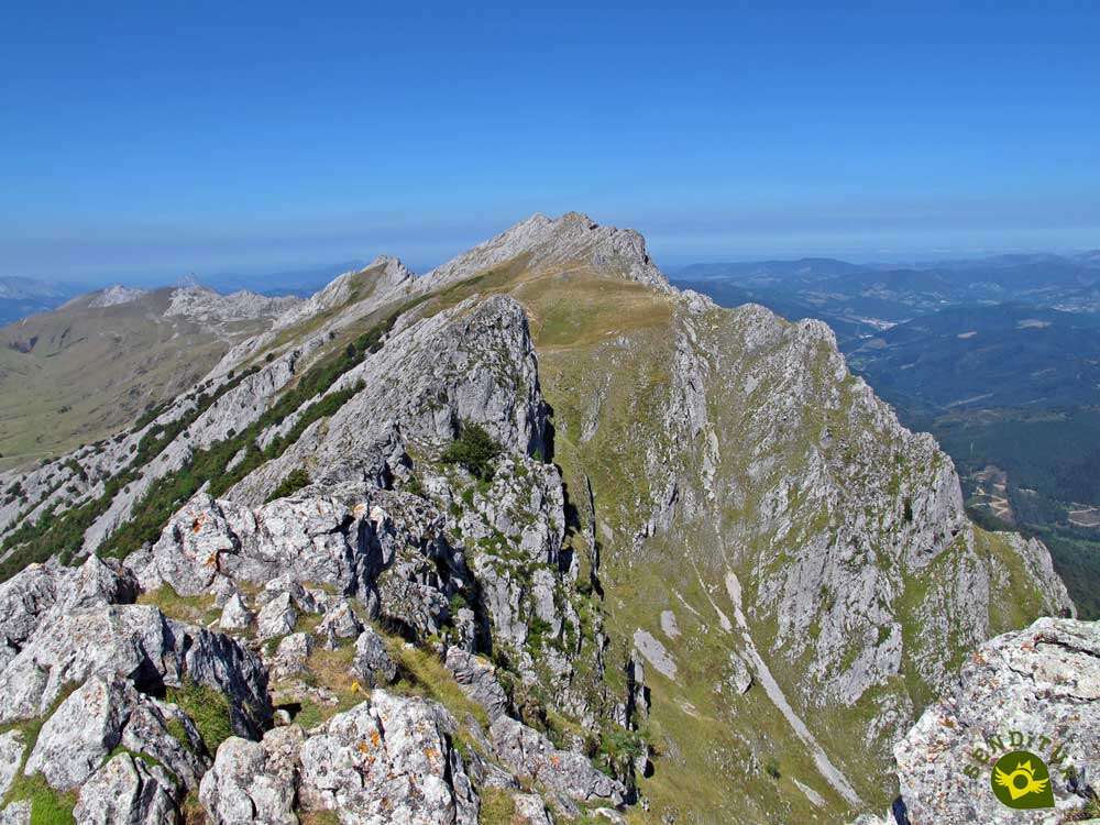
The Aizkorri-Aratz Natural Park is home to curious corners, spectacular natural landscapes and mythical Basque mountains such as the Aitxuri, the roof of Bizkaia. But perhaps one of the most popular ascents is the one that leads to Aizkorri from the Sanctuary of Arantzazu, a route that will not leave us indifferent.

The traditional route extends for about 16 km. In our case, besides including an appetizing detour to crown the Aketegi and Aitxuri, we descend through a less traveled itinerary that returns us to the fields of Urbia, where we will rejoin the traditional route by which we will return to the Sanctuary of Arantzazu, making this way an itinerary of 17,5 km in total. In any case, the route starts from the impressive Arantzazu and climbs steadily up to the green fields of Urbia, passing by the chapel of the same name. From there you can already contemplate the steep silhouette of the mountains we are going to ascend.

Before reaching the hill that precedes the Aizkorri, we took a detour, tempted by the idea of taking advantage of the occasion and crowning the roof of Gipuzkoa, the Aitxuri. A challenging ridge separates us from it, after crowning its summit we set our eyes on the Aizkorri where its well-known axe awaits us and of course, a few meters below, the Santo Cristo hermitage. From here, instead of returning along the same route, we lengthen this route a little more, first descending along the path that goes up from the San Adrián tunnel, to say goodbye to it quickly and enter a leafy forest that will take us to the campa of Olizako and join the GR 121 or Tour of Gipuzkoa, to return together to the campas of Urbia, where we will join the traditional itinerary that will return us to the Sanctuary of Arantzazu.

Legend has it that the goddess Mari has one of her dwellings in a large cave, located at the foot of the mountains that run up the route to the Aitxuri and Aizkorri. And that it is known when she is at home because the valley surrounding these mountains is hit by a great drought, which lasts as long as Mari continues in this cave.
We have to go to Oñati through the GI-2630 road that connects it with Legazpi and the AP-1. From Oñati a winding road arrives until the same Sanctuary of Arantzazu where we will find some spacious parkings. We have to continue by the paved road that borders the sanctuary and to ascend by her leaving it behind. As soon as we finish this road we will find a first parking lot. If we followed the way that continues we will arrive until the last one of the parkings from where we can begin the route. Also there is service of buses that in different schedules unite the Sanctuary of Arantzazu with Oñati.
Look at the picture of 360º
We are in a natural park and we will cross areas where cattle is very common, so it is necessary that we take our dog tied up. The route is quite demanding physically so it is necessary that he is used to follow us in this type of routes.
There are different points where you can drink, although the most demanding section of the ascent does not have water areas. Given the karst area we will cross, it would not be a bad idea to take some boots to protect your legs.
To the autochthonous fauna it is necessary to add the numerous cattle that graze in the fields that we are going to travel and the dogs that usually accompany them.
Our starting point is the first parking lot (0h 00min) that we will find at the end of the road that runs through the sanctuary.

This path that we now have to walk leads to the next parking lot from where, if we are lucky enough to be able to park there, we can also start this beautiful route.

It is from here that the notable slope begins that we will have to overcome, as long as our starting point would not have been the ample parking of the sanctuary.

The marks of the GR 282 or Path of Grazing, the GR 283 or Route of Idiazabal Cheese, the GR 121 or Tour of Guipúzcoa and the PR GI 3006 will accompany us in a good part of the itinerary.

The slope is quite evident and hardly gives us a moment's respite to catch our breath. After a while the path we were following turns into a wide path that will accompany us to the Campas of Urbia.

A path that maintains the upward profile that had been accompanying us. The slope becomes more noticeable as our path begins to draw some curves to save it.

After a while the slope becomes softer, as if it wanted to warn us of our next arrival at the hill before the campas of Urbia. Although we still have a steep slope to enjoy this magnificent natural place.

Once this first ascent of our route is over, we get ready to enjoy the beautiful walk that takes us past the Urbina hermitage (1h 10min).

From there the path descends in search of the refuge a little further on, which we will border on any of its sides.

Once again, a perfect path will be in charge of guiding us in this part of the itinerary. A path that we follow until we meet another that emerges on our left, which we will follow.

This road, which we are walking now, already showed its important slope in front of us, since we crossed the shelter of Urbia.

Without leaving the path at any moment we arrive at some huts that mark the beginning of the path of ascent to the Aizkorri and the Aitxuri among others.

Our route goes through the huts in search of the beginning of this path. A path whose slope makes us strive to gain height with every step.

Soon, when we reach the limit of the grove in front of us, our path enters a karst area where it zigzags following the yellow marks that indicate the route.

After this chaotic stretch we recover the marked path, without losing any of its inclination. In front of us we see a weather vane that makes us think that we are close to the top, nothing is further from reality.

From the weather vane, the slope does seem to lose some of its inclination, but we still have a good stretch to reach the summit of Aizkorri. After a while we arrive at a milestone, just where our path divides into two, which come together again later.

This kneeling stone marks the path that on our left ascends directly to the nearby peaks of Aketegi and Aitxuri, the roof of Gipuzkoa. In our case we cannot resist the temptation to crown these Basque mountains and leave the path that leads to the next collado that separates them from the Aizkorri, to begin the ascent to them.

An ascent that leads us to meet the path that we will use to reach the hill without going back down to the detour. Already on the steep crest of the mountain we crown the Aketegi first.

From there, and with the caution required by this type of terrain, we follow the yellow marks that lead us up to the Aitxuri.

Once we have enjoyed these peaks, we return following our steps until we find the path we have to follow.

Without losing much height, the path we are looking for appears little by little before us, leading us to the collado that awaits us further on. The hill where we will take the official route of ascent to the Aizkorri.

Ahead of us we have a rather steep stretch, where the highly polished stones of the path that we walk indicate how crowded this mountain usually is.

Once again we see ourselves zigzagging its hillside, following the yellow marks with our eyes set on the cross that crowns it.

The path is divided into two, one leads directly to the hermitage of the Santo Cristo. And another one, the one we follow, takes us straight to the summit of the Aizkorri (3h 20min), to then descend to the other one that brings us closer to the hermitage.
The great majority of people who climb the Aizkorri from the Sanctuary of Arantzazu, besides not crowning the Aitxuri, descend following the same route by which they ascended, thus making a route of 16 km in total.

We are going to lengthen the route a little more by going down the route that comes from the San Adrián Tunnel.

Although we quickly say goodbye to the first of the paths that ascend from San Adrián, leaving it to our left to continue descending.

Almost immediately we leave behind another path, which this time brings us closer to the nearby Tontorraun, and where you can also reach the San Adrian Tunnel.

We continue to lose height rapidly under the watchful eye of the mountain we have just climbed.

After a while, the forest makes an appearance, and we say goodbye to the access roads to the San Adrián tunnel, to continue with our route.

This stretch through the forest will force us to be careful not to lose the path we must follow. We'll find some stone landmarks that can help us.

Although almost at all times it takes us along the hillside of the mountain we have just climbed. After a while the forest leaves us at the beginning of the last stretch of descent that we will have to face in this part of the route.

Here we radically change our orientation in search of the campa we see at our feet. Once there, we follow the row of stones that mark the path that passes through here.

Soon we reach a path that we must follow for a few meters. Soon we say goodbye to the path to join the route of the GR 121.

Once again, we must pay attention to the marks that indicate the route so as not to walk more than we should. The path takes us back to the interior of a leafy forest. Once inside the forest, the GR 121 leads us through it in a continuous up and down movement.

At this point in the route this uneven stretch becomes a little more demanding than it really is. But the landscape around us more than compensates for the extra effort this variant entails.

The end of the forest warns us of the proximity of the Urbia campas, although we still have another hill to climb.

Shortly before the end of the ascent, we left the path to shorten the route a little. This small shortcut that makes the GR 121 avoids us go through the curve that draws the path.

A path that descends quickly leading us directly to the campas of Urbia.

Once in them we will find the path by which we ascended the Aizkorri, thus closing the circular route that we have made.

The only thing left to do is to return to the parking lot (5h 50min) from where we left following the route we took to Urbia.
 Distance. 17.5Km
This figure varies depending on where we park our vehicle. Not making the extension to the summits of the Aketegi and Aitxuri is approximately 500 m less.
 Time. 5:50h
As with the distance figure, parking in one or another parking lot influences the time we will need, as the sanctuary parking lot is about 700 m away from the final parking lot. Even more difference we will have of not facing the ascent to the other two peaks, in this case we will save from 30 to 45 minutes.
 Time of year
The landscape and natural environment surrounding this route is a spectacle all year round. The fogs considerably distort the route, while the autumn and spring with their colors give an added value to the route. The hot days can put us in trouble in the final stretch of the ascent, since there is not even an area of shade.
 Required equipment
This is a fairly touristy mountain route, but it should not be underestimated. Carrying enough water, warm clothes and windbreaks even in summer, some hiking poles and footwear suitable for this type of terrain is something that not many people carry in the Aizkorri and we do not say carrying a backpack with the minimum for any route. We always have to carry the necessary material that allows us to follow the correct route in case of doubt, but if our idea is to lengthen the route, as we explain here, the GPS with the track. Consult our list of material and equipment for hiking. Read more.
 Difficulty. Remarkable
Physical
Both the difference in level and the mileage to be achieved require that we be in good physical condition, even if we only follow the usual route of ascent and descent of the Aizkorri. Another good idea is to face the ascent with calm from the first moment of the route. In this type of routes it is not a good idea to spend all our energy in going fast at the beginning of the route.
Severity of the environment
The polish on many of the stones on the trail makes them very slippery even when dry. We should not venture into the ridge section between the Aketegi and the Aitxuri without having the necessary experience for this type of terrain. It is a fairly aerial area that has good grips but does not allow for mistakes. As for the rest, and always taking into account the possible rock falls that can occur in this type of terrain, the traditional route of ascent to the Aizkorri does not involve any major complications, always in good weather conditions and good condition of the terrain. Watch out on the descent, slips are quite common.
Orientation
Well marked and clearly defined the path to follow, we should not have complications in this section, always in good general conditions. If we venture into the different variants that we develop here is where we can have problems in this section because they are not as busy or as well marked as the traditional route.
 |
 |
 |
 |
 |
| 1-Parking | 0:00h | 748m | 0Km | 30T 549257 4758546 |
| 2-Hermitage of Urbia | 1:25h | 1155m | 4,1Km | 30T 552370 4756942 |
| 3-Campas of Urbia | 1:30h | 1123m | 4,6Km | 30T 552772 4756724 |
| 4-Aitxuri | 2:55h | 1551m | 7,4Km | 30T 554653 4756456 |
| 5-Aizkorri | 3:20h | 1523m | 8,5Km | 30T 555044 4755630 |
| 6-Campas of Urbia | 4:40h | 1123m | 12,9Km | 30T 552772 4756724 |
| 7-Hermitage of Urbia | 4:50h | 1155m | 13,4Km | 30T 552370 4756942 |
| 8-Parking | 5:50h | 748m | 17,5Km | 30T 549257 4758546 |
Coordinates UTM Datum WGS84

 Slope: 2084m
 Slope +: 1042m
 Slope -: 1042m
 Maximum altitude: 1551m
 Minimum altitude: 748m

This sketch of the route is not made to scale nor does it contain all the information relating to the area, it is merely indicative

![]()
This schematic with the path is approximate and has been created from the derived cartographic base © Instituto Geográfico Nacional "Cuadrante 113-1 y 113-2, 25.000"
Senditur has manipulated the tracks to correct the aberrant points that may exist, caused by problems with the reception of the GPS signal. In any case the tracks are always approximate. SENDITUR encourages you to use the new technologies within your reach, using them as support and consultation in your activity, not basing the realization and orientation of the same only and exclusively on them, since they may see their functioning altered by very diverse causes, not functioning correctly and their indications may not be precise.


La subida al Aizkorri desde el santuario de Arantzazu es una de las que más me ha gustado de esta zona. Muy recomendable si te gusta la montaña.


Where the highest peaks of the Basque Country can be found


Find out what to see in...
¿Did you know that...
In the hermitage of the Santo Cristo a crucifix is kept to which it owes its name. It is said that this crucifix, no matter how much it was taken to other places, always reappeared in the hermitage of the Aizkorri.
Don't miss out...
The environment of Oñati has numerous tourist and cultural attractions, one of the best known is undoubtedly the sanctuary of Arantzazu, having an unbeatable opportunity to visit it when making this ascent.


From the commitment of SENDITUR with Nature and the respect to the balance of the environment, SENDITUR urges you to travel in a responsible way, with low environmental impact and respecting at all times the Natural, Cultural and Social environment wherever you go.

Besides sharing with all of us your experience on the route we would be grateful if you could write to us to inform us of any erroneous or outdated information you may have found, or simply to let us know what you think at Thank you.
This route has been carried out in the field by SENDITUR on 10-09-2020. The route may vary greatly depending on the time of year, weather conditions and terrain, as well as the actions of third parties and the evolution suffered in the natural environment where it is located. All opinions, advice and/or assessments made by SENDITUR in their descriptions are for guidance only and are subject to and/or refer to the specific conditions of the specific day of the route, referring to that specific day, taken from trained people, with the appropriate experience and with a high level of physical and technical preparation as a reference, as well as correctly equipped.
All the times are approximate and take an orientative character, the stops have not been taken into account, no matter how small they are. All the information related to the route, texts, images, videos, maps, diagrams, tracks, towns, and places of tourist interest are published as a guide, and may not coincide with the current state of each place. Before undertaking any activity, assess your technical knowledge, your physical condition, find out about the weather and the variations that the route may undergo, equip yourself correctly, be prudent and responsible at all times, and do not exceed your capabilities. SENDITUR is not responsible for any misuse or inappropriate use of the comprehensive guides of its routes and/or publications as well as its electronic guides, nor for any variations in their descriptions for the aforementioned reasons, and recommends that everyone be responsible and prudent in carrying out the activity. We also encourage you to read books and specialised guides to complement the information described above.
Continue watching …


.jpg "Go to Sanctuary of Our Lady of Arantzazu")
.jpg "Go to Aizkorri-Aratz Natural Park")


