Welcome to SENDITUR.COM · paths · routes · tourism


![]() Difficulty-Low
Difficulty-Low
![]() 0:20 h.
0:20 h.
![]() 0.8 km.
0.8 km.
![]() Difficulty-Low
Difficulty-Low
![]() 0:20 h.
0:20 h.
![]() 0.8 km.
0.8 km.
The region of Tarazona, in Zaragoza, holds countless treasures created by the tireless work of nature, geological formations that surprise visitors and have accompanied the inhabitants of these lands for centuries, always under the protection of the unmistakable San Miguel Peak, the Moncayo. One of the most curious of these legendary formations is undoubtedly the Well of the Aines, located next to the town of Grisel, a legendary doline that houses a varied habitat.

The route that brings us to it is barely 0.8 km long, a little more if we start from Grisel. It is a pleasant walk among the olive trees that populate these lands, but not before enjoying the magnificent view offered by the privileged viewpoint that is located in the parking lot from which we started the journey. We travel the short distance that separates us from this unique karstic cavity with our eyes set on the monumental Tarazona, but soon we will be surprised by this doline produced by the action of the waters that flow from the Moncayo on the lands we are treading. The Well of the Aines, with its 23 m of depth, besides being a place full of legends has become a place of incalculable natural and geological value, thanks in part to the peculiar microclimate of its interior.

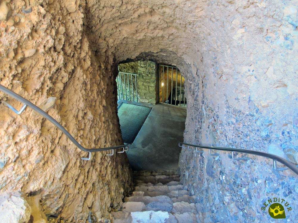
The fact is that it grows ferns like the Deer Tongue or long and resistant vines that, thanks to the humidity and the 10 degrees less average that there are in its interior, do not occur in the typical Mediterranean landscape of the outside. Undoubtedly we are in front of an extraordinary geological formation of which we do not know with certainty its origins although we already have evidence of it in the 16th century. Inside, we can also see carvings on the walls of various dovecotes, which, together with the cave that allows us to descend to the interior viewpoint, testify to the human use of this doline. On our return, surrounded by olive trees, we find even more surprising the unique habitat we have just visited, surrounded by the magical atmosphere of legend that accompanies the Well of the Aines.

Many are the legends that accompany the Well of the Aines, a wealthy Moor who, ignoring the precept of not working on holidays, that cost him his life, as the earth opened up under his feet. Secret passages that served to flee, in case of siege, from the nearby castle. Or the one that refers to a young and beautiful maiden named Agnes who, one spring day, walked up to the chasm and, disregarding the warnings, looked out curiously at the edge of the well and as if an unnatural force were pulling her in, she fell into it and disappeared forever.
To get to Grisel we must set course for Tarazona, as it is in the vicinity of this town where we will find the road that gives access to Grisel. More specifically, this access road to the town is located in the middle of the N-122 shortly after leaving Tarazona in the direction of Zaragoza or shortly before reaching it if we come from Borja. Once in Grisel, just before entering the town we will find the detour that, signposted, leads to the Well of the Aines, making us leave Grisel behind. Shortly before we arrive, we will have a large area set aside as a car park where we can park our vehicle and head for this peculiar chasm.
An excursion without major complications for our dog, but we do not have to let him walk at his own choice, and we must prevent him from exceeding the limits of the railing that surrounds the chasm.
It is not a bad idea, especially if we do the route from Grisel, that we bring him some water, even more if the day is hot.
Except for some more pets we should not find more animals in the area, beyond the fauna that lives there.
 Distance. 0.8Km
This figure increases considerably if we have to reach the well from the locality.
 Time. 0:20h
If we take Grisel as our starting point, we will have to increase this figure by another 20 or 25 minutes approximately.
 Time of year
The special conditions inside the Well of the Aines make it an obligatory stop throughout the year if we visit the area. Of course, depending on the time of year we choose to visit it, it will affect its splendour and liveliness, but even in the middle of summer it is a good option thanks to its special characteristics.
 Required equipment
Approaching the chasm from the parking lot is a short walk that we can do comfortably, a comfortable shoe or sport and the camera is how much initially, in normal conditions, we should need. We must not forget to protect ourselves from the sun and take some water on hot days, especially if we go with the children. Consult our list of material and equipment for hiking. Read more.
 Difficulty. Low
Physical
The short distance that separates it from the parking area and the little unevenness to overcome, should not create complications. If we choose to approach it from Grisel, the demand in this section would not increase significantly either.
Severity of the environment
Common sense advises us, along with the signs we will find, not to go beyond the fence that delimits the doline we are visiting, since doing so would expose us to an almost certain fall into the void given the conditions of the terrain. As long as we limit ourselves to moving through the areas marked out for this purpose, we should not have any problems. Be careful with the stairs that lead to the interior of the well and with the head when accessing the viewpoint.
Orientation
The route is signposted from Grisel itself. It also runs along tracks in good condition and coincides almost to the end with the GR route that runs through this area of the province of Zaragoza. The only doubt may arise in the vicinity of the Well of the Aines, as the GR marks take us along the path on the left that borders the olive grove where the doline is, and if we do not pay attention to the fencing of the chasm that we see on our right, it may go unnoticed. If, on the other hand, we choose the path on the right, it will take us directly through the olive grove to the Well of the Aines.
 |
 |
 |
 |
 |
| 1-Parking | 0:00h | 627m | 0Km | 30T 604989 4636598 |
| 2-Well of the Aines | 0:10h | 611m | 0.4Km | 30T 605038 4636848 |
| 3-Parking | 0:20h | 627m | 0.8Km | 30T 604989 4636598 |
Coordinates UTM Datum WGS84

 Slope: 36m
 Slope +: 18m
 Slope -: 18m
 Maximum altitude: 627m
 Minimum altitude: 611m

This sketch of the route is not made to scale nor does it contain all the information relating to the area, it is merely indicative.

![]()
This schematic with the path is approximate and has been created from the derived cartographic base © Instituto Geográfico Nacional "Cuadrante 320-3, 1:25.000"
Senditur has manipulated the tracks to correct the aberrant points that may exist, caused by problems with the reception of the GPS signal. In any case the tracks are always approximate. SENDITUR encourages you to use the new technologies within your reach, using them as support and consultation in your activity, not basing the realization and orientation of the same only and exclusively on them, since they may see their functioning altered by very diverse causes, not functioning correctly and their indications may not be precise.


Beautiful stone garden, one of the main Cistercian foundations in Spain


First Cistercian monastery to be established in Spain


Place of burial of a holy body, Saint of the River, Saint of the Duero


Find out what to see in...
¿Did you know that...
There are several chasms and caves that we can find throughout this region, all of them full of legends about their formation or superstitions about who inhabited them, even some of them have been the protagonist of well-known literary passages.
Don't miss out...
The town of Grisel, in addition to its restored castle and sixteenth-century church of the Assumption, we can discover the typical Casillas de pico, climb to the Viewpoint of the Diezma or walk through its streets that still retain their character, a mixture of Moorish and Christian culture of the Middle Ages.


From the commitment of SENDITUR with Nature and the respect to the balance of the environment, SENDITUR urges you to travel in a responsible way, with low environmental impact and respecting at all times the Natural, Cultural and Social environment wherever you go.

Besides sharing with all of us your experience on the route we would be grateful if you could write to us to inform us of any erroneous or outdated information you may have found, or simply to let us know what you think at Thank you.
This route has been carried out in the field by SENDITUR on 02-09-2017. The route may vary greatly depending on the time of year, weather conditions and terrain, as well as the actions of third parties and the evolution suffered in the natural environment where it is located. All opinions, advice and/or assessments made by SENDITUR in their descriptions are for guidance only and are subject to and/or refer to the specific conditions of the specific day of the route, referring to that specific day, taken from trained people, with the appropriate experience and with a high level of physical and technical preparation as a reference, as well as correctly equipped.
All the times are approximate and take an orientative character, the stops have not been taken into account, no matter how small they are. All the information related to the route, texts, images, videos, maps, diagrams, tracks, towns, and places of tourist interest are published as a guide, and may not coincide with the current state of each place. Before undertaking any activity, assess your technical knowledge, your physical condition, find out about the weather and the variations that the route may undergo, equip yourself correctly, be prudent and responsible at all times, and do not exceed your capabilities. SENDITUR is not responsible for any misuse or inappropriate use of the comprehensive guides of its routes and/or publications as well as its electronic guides, nor for any variations in their descriptions for the aforementioned reasons, and recommends that everyone be responsible and prudent in carrying out the activity. We also encourage you to read books and specialised guides to complement the information described above.
Continue watching …


.jpg "Go to Royal Monastery of Santa María of Veruela")
.jpg "Go to Aguarales of Valpalmas")


