GR 190 Section 2 Valvanera-Viniegra de Abajo
Touring part of the Seven Villas
Touring part of the Seven Villas
In the region of The Seven Villas, crossing part of the valleys that nourish to the valley of the Najerilla, in the Sierra of La Demanda, we find this stage of the GR-190, the one of The High Valleys Iberian. This spectacular spot that surrounds the river Najerilla before it flows into the wide valley of the Ebro, offers us a mixture of rounded mountains with narrow valleys.

We will be able to enjoy the magnificent panoramic views of the mountain range and its valleys that we will have in great part of the route, in addition to a varied vegetation with old oaks that await us in the meadow. The GR 190 section 2 Valvanera-Viniegra de Abajo with 16,1 Km, begins in the Monastery of Valvanera that together with its Benedictine monks has always been part of the history of this land and of its people, who arrived in pilgrimage, from the near and not so near towns, to it.

The path leads to the top of the valley, where the Pancrudos, from their privileged balcony, contemplate the day-to-day life of the monastery, to skirt them and jump to the other side in search of the Rigüelo ravine, which we will descend from the Pass of Ocijo to meet the river that gives it its name.

Following the course of the river, a tributary of the Najerilla, we will reach it and the Venta de Viniegra, better known as the Venta de Goyo, from where, going up the course of the river Urbión, we will reach Viniegra de Abajo, an old town in La Rioja, in whose town centre a Visigothic stele has been found, among other antiques, which testify to the great history of this town.
Legend has it that the city of Lutia was located in what we know today as Viniegra de Abajo and that its inhabitants tried to help the besieged Numancia and were punished for it in the mountain known as The hill of the Treason (in the Sierra of Urbión).
To get to Anguiano, we will follow the LR-113 that links Nájera with the Burgos town of Salas de los Infantes. This same road in Nájera connects with the A-12, Autovía del Camino and the N-120 between Burgos and Logroño. There is an extensive schedule of intercity buses that connect Anguiano with both Nájera and Logroño. Once there we arrive at the monastery following the LR-113 from Anguiano towards Mansilla, it is in this section and after approximately 9 Km from Anguiano and 20 from Mansilla de la Sierra, where we will find the junction with the road that goes up to the Monastery of Valvanera. Going up this road we will arrive at the monastery, both at the entrance and crossing the arcade to the inn are the parking areas enabled.
Good journey for our partner, by dirt road at the beginning, footpath later and unfortunately road in its last part, with what this means. The trails are largely covered with bushes and the unpleasant thorn bushes.
Livestock area, it is common to meet with the cattle that graze in these places.
We will pass through several places where we will find small streams, we can not leave aside the water supplies, as the irregular flow of these does not ensure their availability. At the beginning of the itinerary, in Valvanera, as well as in Venta de Goyo and Viniegra de Abajo we have water points insured, without counting the passage through the river Rigüelo.
Variant: Link GR 93 GR 190 Anguiano-Valvanera
We start from the Monastery of Valvanera (0h 00min), between the bar and a fountain there are some stairs and we start to climb them.

At one point we come across a metal door that leads to a house, we go through the door and make a right turn where there is a door, which we go through. We continue straight ahead accompanied on the right by a wire fence until we see a detour to the left where we continue and enter a forest of holm oaks.

A little further on we see a building, which is a water tank, we keep going and we reach a fork where on the left there is a path that leads to some beehives and on the right another path that we must follow.

We keep going up until we find the track where we turn right, we won't leave it for a few kilometers.

After a few bends in the road, we reach the beginning of a trail on the right, where we will go up, this trail will cross the track again and going straight on the trail on the other side, we will reach the exit of the Forest.

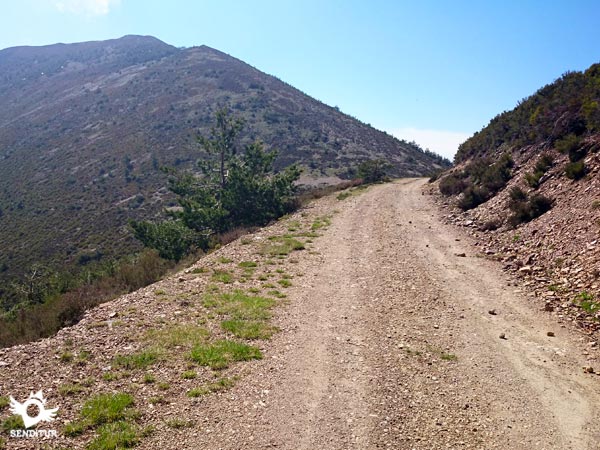
Once at this point, turn left and go along the edge of the forest, gradually separating until you reach a firebreak that leads to an uphill forest track, which you will not leave until you reach a well-marked junction where the Valvanera track and the track from Ezcaray to Viniegra converge. Take the track towards Viniegra, on the left hand side. This track is in good condition and has a considerable width.

On our left the views are unbeatable, we can see the whole valley where the monastery of Valvanera is located, which seems to turn and get closer as we approach the Pass of Ocijo.

The tones of the valley are also remarkable, given the type of trees and vegetation on its slopes.

As we arrive at the pass, the landscape changes and the Sierra of Urbión can be seen on the horizon. In the Pass of Ocijo (2h 05min) several tracks converge, we must continue straight until we pass through the middle of the frames of an old gate, leaving on the right the refuge of Ocijo and all the tracks that go out to that side.

If we came in the opposite direction, we would take the track that is in front, more to the right, and that obviously borders the Valvanera valley.
As for the shelter we must say that when we visited it was clean, with some wood in the fireplace and working the "bar" of LED lights located on the roof has been lit just give the switch. We took our way back to the track and continued our descent.

After a while and when the track changes its inclination, to start climbing, just at that point we must turn on a footpath that goes to the right, we must be careful because it does not look very good. If we have any doubts, if we follow the trail with our eyes we will see that a few meters below there is a door with about three steps and the red and white marks on one of its beams.

The road surface changes completely, it is decomposed, we find stones, vegetation invading the trail and we have to be careful not to slip. We reach the gate and pass it on the left side, the trail getting narrower and narrower.

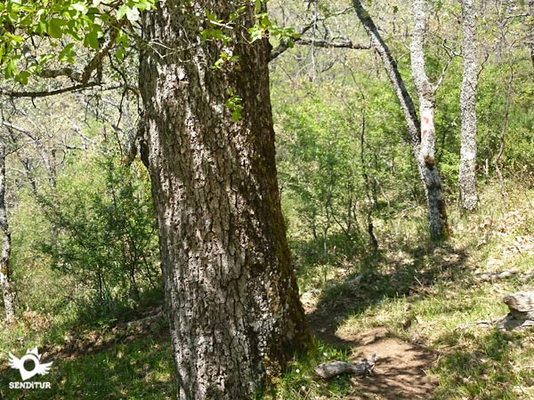
We go into an oak grove and leave on the left side two incipient springs whose drops make a small stream that wets the path, in the last of them you can see in its upper part the stone wall that could belong to a building already demolished.

We followed the descent and soon after we arrived at an esplanade where the trees seem to be in order. If we look to the front, we will notice that there are remains of a building, its walls are made of stone and we must head there from the beginning, although before reaching it we must turn slightly to the right.

We will enter the oak grove again leaving a detour on the left, the path is totally blurred at this point and if it were not for the red and white marks that indicate the GR in the trees would be very difficult to follow the path.

This is an area where you have to pay special attention to the signs. The path zigzags around in tight corners and only at some points do you sense where it is going, as it is practically covered with vegetation.

Once these changes of direction are completed, the descent is softened and we cross another incipient spring. A little further on we can observe how some large oaks dot the road, reminding us of their antiquity.

After several turns to the left and right we arrive at a small sheepfold, the views of the valley are spectacular and the surroundings invite you to take a short break.

We continue our way turning to the right, starting the steepest descent, zigzagging, while we already hear at the bottom of the Rigüelo valley the rumour of the river that gives it its name.

When you reach the bottom of the valley you walk sometimes on the right side of the river and other times on the left side crossing three footbridges of different size, not being a great distance between them.

Leaving the last one and taking the river that has accompanied us in this part of the tour to our left, we arrive at a gate that we must cross.

A little further on we cross again a small cement bridge with a railing that passes us on the left side of the river from where we access the old road, in the middle of a bend between a "quitamiedos" and the side of the mountain.

As we climb up this old road, the path turns sharply to our right to go down it, crossing the river again. Following it, we reach the junction with the new road (3h 15min) between Nájera and Salas de los Infantes, where we turn right and continue along the GR.

Shortly after following this road that goes up the course of the Najerilla River we reach the place known as Venta of Goyo.

The road divides the buildings that form it by crossing it from side to side. As soon as we pass the petrol station on this site we reach the crossroads with the road to Viniegra de Abajo and Ventrosa, at which point the road turns left to continue along it, crossing the bridge over the Najerilla, and continuing on without leaving the road until we reach our destination.

Our new route enters another valley by ascending it with the typical winding pattern of mountain roads, we must not leave its layout.

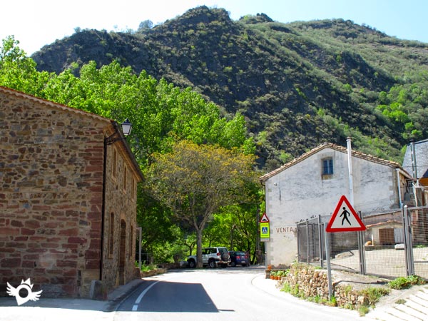
Shortly before reaching the end we will find on the left hand side the crossroad that if we follow it would take us to Ventrosa, leaving this crossroad and following the main road we will reach the entrance of the town.

The path turns, leaving the road for a few metres to cross an old footbridge and meet it again on our right, and then follow it again to Viniegra de Abajo (4h 15min), where this itinerary ends.
Our final destination marks the total distance to be covered.
Total time without stops, it is advisable to take the ascent from Valvanera to the pass calmly since the descent towards the river and the back part by road can be somewhat long.
In winter, the height of the route, makes it usually covered by snow to a large extent, hiding bot:the pat:and many signs. The rest of the year the route offers us a magnificent and colourful landscape, as well as allowing us to enjoy the leafy forests that surround it.
Trekking shoes and clothes according to the time of year and weather conditions, warm and rain clothes, backpack, walking sticks, canteen and food. Long trousers and boots are recommended, as well as a photo camera and binoculars. Consult our list of material and equipment for hiking. Read more.
Physical
It is not an excessively long route, if it is hardened by its first part, whic:is constantly uphill, and by the steep descent ramps throug:the pastures of Viniegra de Abajo to the road. Once on it, althoug:it runs throug:magnificent landscapes, the ascent to Viniegra becomes somewhat heavy.
Severity of the environment
The route runs largely on dirt tracks and roads, wit:no greater problem than the dangerous traffic that we can encounter there. We must pay attention in certain areas of the trails to avoid slipping, as the slope of the terrain and the somewhat roug:state of it make them very likely.
Orientation
Well signposted, it is the exuberant vegetation that covers the pat:at certain points of the journey, when we descend towards the river, whic:makes it extremely difficult for us to walk. We have to pay special attention in this part of the itinerary to the GR marks that we will normally find at half height on the tree trunks.
| 1-Monastery of Valvanera | 0:00h | 1000m | 0Km | 30T 510620 4675373 |
| 2-Pas of Ocijo | 2:05h | 1745m | 7Km | 30T 508253 4673047 |
| 3-Road | 3:15h | 835m | 12.7Km | 30T 509541 4669363 |
| 4-Viniegra de Abajo | 4:15h | 875m | 16.1Km | 30T 509156 4666734 |
Coordinates UTM Datum WGS84

![]() Slope: 1831m
Slope: 1831m
![]() Slope +: 879m
Slope +: 879m
![]() Slope -: 952m
Slope -: 952m
![]() Maximum altitude: 1736m
Maximum altitude: 1736m
![]() Minimum altitude: 844m
Minimum altitude: 844m

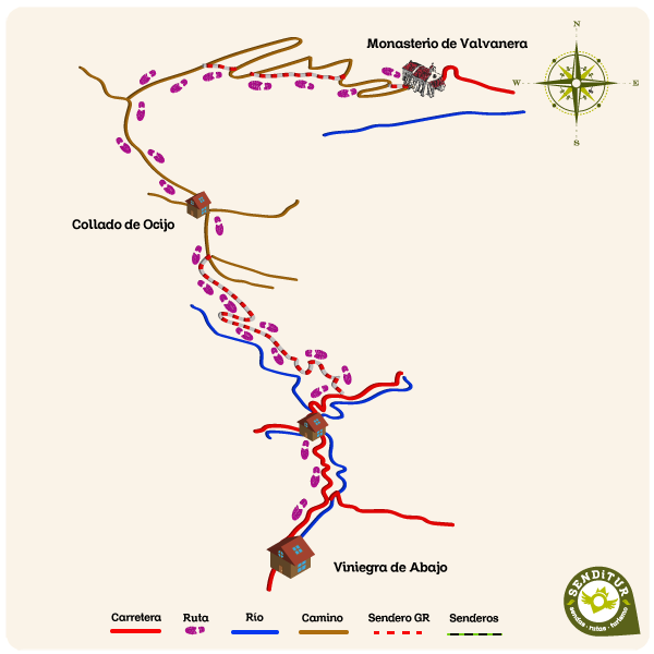
This sketc:of the route is not made to scale nor does it contain all the information relating to the area, it is merely indicative.

This schematic wit:the pat:is approximate and has been created from the derived cartographic base © Instituto Geográfico Nacional "Cuadrante 240-4, 278-2 1:25.000".
Senditur has manipulated the tracks to correct the aberrant points that may exist, caused by problems wit:the reception of the GPS signal. In any case the tracks are always approximate. SENDITUR encourages you to use the new technologies within your reach, using them as support and consultation in your activity, not basing the realization and orientation of the same only and exclusively on them, since they may see their functioning altered by very diverse causes, not functioning correctly and their indications may not be precise.
Find out what to see in...
¿Did you know that...
The Monastery has suffered serious fires, one of them caused in 1809 by Napoleon's troops during the War of Independence. Shortly afterwards, with the confiscation of Mendizábal, the monastery was left in a state of total abandonment.
Don't miss out...
The spectacular landscape from the Pass of Ocijo from the valleys of the two slopes of the Pancrudos, Valvanera and Rigüelo.
From the commitment of SENDITUR with Nature and the respect to the balance of the environment, SENDITUR urges you to travel in a responsible way, with low environmental impact and respecting at all times the Natural, Cultural and Social environment wherever you go.
Besides sharing with all of us your experience on the route we would be grateful if you could write to us to inform us of any erroneous or outdated information you may have found, or simply to let us know what you think at Thank you.
This route has been carried out in the field by SENDITUR on 23-05-2015. The route may vary greatly depending on the time of year, weather conditions and terrain, as well as the actions of third parties and the evolution suffered in the natural environment where it is located. All opinions, advice and/or assessments made by SENDITUR in their descriptions are for guidance only and are subject to and/or refer to the specific conditions of the specific day of the route, referring to that specific day, taken from trained people, with the appropriate experience and with a high level of physical and technical preparation as a reference, as well as correctly equipped.
All the times are approximate and take an orientative character, the stops have not been taken into account, no matter how small they are. All the information related to the route, texts, images, videos, maps, diagrams, tracks, towns, and places of tourist interest are published as a guide, and may not coincide with the current state of each place. Before undertaking any activity, assess your technical knowledge, your physical condition, find out about the weather and the variations that the route may undergo, equip yourself correctly, be prudent and responsible at all times, and do not exceed your capabilities. SENDITUR is not responsible for any misuse or inappropriate use of the comprehensive guides of its routes and/or publications as well as its electronic guides, nor for any variations in their descriptions for the aforementioned reasons, and recommends that everyone be responsible and prudent in carrying out the activity. We also encourage you to read books and specialised guides to complement the information described above.
Continue watching …